You will get Drone Data Integration & Spatial Analysis (Roof Inspections)
Project details
Are you an inspection company, contractor, or surveyor struggling to quantify roof damage from drone images?
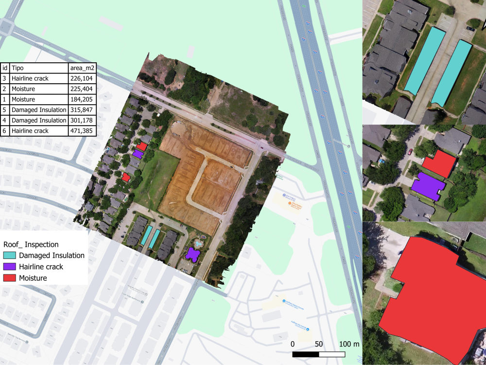
I specialize in transforming raw aerial orthomosaics into precise, actionable GIS data. With a strong background in architectural drafting and spatial analysis, I don't just draw lines I create categorized thematic maps that automatically calculate the exact damage areas (m2 or sq ft) for moisture, cracks, and insulation degradation.
This ready to use data streamlines your reporting process, saving you hours of manual work in presentation software and providing your clients with professional, highly accurate results. Let's elevate your drone data!
I specialize in transforming raw aerial orthomosaics into precise, actionable GIS data. With a strong background in architectural drafting and spatial analysis, I don't just draw lines I create categorized thematic maps that automatically calculate the exact damage areas (m2 or sq ft) for moisture, cracks, and insulation degradation.
This ready to use data streamlines your reporting process, saving you hours of manual work in presentation software and providing your clients with professional, highly accurate results. Let's elevate your drone data!
Project Scale
CityBuilding Type
Commercial, Institutional & Public, ResidentialFile Format
DWG, JPG, OBJ, PDFWhat's included
| Service Tiers |
Starter
$60
|
Standard
$115
|
Advanced
$190
|
|---|---|---|---|
| Delivery Time | 2 days | 3 days | 4 days |
Number of Revisions | 1 | 2 | 3 |
Number of Diagrams | 1 | 3 | 4 |
3D Modeling | - | - | - |
Source Files | - |
Frequently asked questions
4 reviews
(2)
(1)
(0)
(0)
(1)
This project doesn't have any reviews.
DR
Daniel R.
Jul 28, 2026
Shed Design Using AutoCAD
Freelancer did not complete the work as needed
The revisions got progressively worse, somehow
Then just stopped replying all together when I sent partial payment
The revisions got progressively worse, somehow
Then just stopped replying all together when I sent partial payment
SS
Snezana S.
Jun 10, 2026
Revit project
JF
Jan F.
Jun 10, 2026
PDF assembly from scanned images (20 scans = 40 pages) + cleanup
Wonderful experience, great job done, thank you!
BL
Ben L.
May 7, 2026
Style Mapbox Map like the attached image
About Andrea
Architectural Designer & Visualizer | AutoCAD, Revit, QGIS & Mapbox
80%
Job Success
Luque, Paraguay - 10:42 pm local time
I am an Architectural Designer who bridges the gap between rigid technical standards and stunning visual communication. I don't just draw lines; I structure data so it works for you in the real world.
Here is how I can add value to your project:
📐 Bulletproof Drafting & BIM: Whether you need a 1:50 A3 planning application that breezes through city councils or a highly coordinated Steel Framing Revit model, I deliver clean, meticulously layered, and precise files (AutoCAD & Revit). No messy layers, no scale errors.
🎨 Visuals That Sell: I take flat, highly technical CAD layouts and breathe life into them using Photoshop. By adding realistic textures, lighting, and contextual landscaping, I turn engineering documents into beautiful presentation boards that developers and clients instantly understand and love.
🌍 Bespoke Cartography (Mapbox & QGIS): I manipulate territorial data. From editing Style JSONs to precise POI filtering, I build clean, interactive, and highly stylized maps (even matching specific aesthetics like video game environments) for urban analysis or digital projects.
Forget the headache of micromanaging freelancers. I bring proactive communication, an understanding of international drawing standards, and a sharp eye for detail to every single milestone.
Send me a message with your project brief or raw files, and let’s figure out the smartest way to get it done.
Steps for completing your project
After purchasing the project, send requirements so Andrea can start the project.
Delivery time starts when Andrea receives requirements from you.
Andrea works on your project following the steps below.
Revisions may occur after the delivery date.
Data Review & Setup
I will review your high-res orthomosaic and set up the coordinate system in QGIS to ensure accurate real-world measurements
Vectorization & Spatial Analysis
I will precisely digitize the specific roof areas, categorizing damages (moisture, cracks, etc.) and generating an automated attribute table with exact area calculations