You will get Accurate GIS and Remote Sensing Analysis.
Project details
You will get highly Accurate GIS and Remote Sensing Analysis through Python, Google Earth Engine, ArcGIS, QGIS, or any other software. I have 4+ Years of Experience with 20+ projects. My top priority is to provide transparent, consistent updates at every stage of the project, ensuring the final deliverable not only meets but exceeds your expectations.
Machine Learning Tools
ArcGIS, ChatGPT, Microsoft Excel, NumPy, Python, PyTorch, Sonnet, SQL, TensorFlowWhat's included
| Service Tiers |
Starter
$30
|
Standard
$50
|
Advanced
$100
|
|---|---|---|---|
| Delivery Time | 4 days | 8 days | 12 days |
Number of Revisions | 1 | 5 | Unlimited |
Number of Model Variations | 1 | 3 | 6 |
Number of Scenarios | 1 | 2 | 6 |
Number of Graphs/Charts | 3 | 6 | 10 |
Model Validation/Testing | - | - | |
Model Documentation | |||
Data Source Connectivity | - | ||
Source Code | - | - |
1 review
(1)
(0)
(0)
(0)
(0)
This project doesn't have any reviews.
JB
Jonas B.
Apr 7, 2025
Map Creation Specialist for Topography and City Maps
Excellent work!
About Fahad
GIS/Remote Sensing Analyst & Developer
Islamabad, Pakistan - 12:55 am local time
🔑 Core Services:
GIS & Mapping Solutions
Custom web maps, dashboards, and geospatial analytics (ArcGIS Pro, QGIS, Python).
Climate risk analysis, site selection, and georeferencing (e.g., identifying coastal cities with specific demographics or zoning criteria).
Data digitization, geocoding, and CAD/GIS file conversions.
AI & Development
ChatGPT integration, Google Cloud Vision.
Automation via scripting (Python, PostGIS).
Training & Strategy
ArcGIS Pro best practices, data visualization.
🛠️ Tools & Skills:
ArcGIS Pro | QGIS | Python | Adobe Creative Suite | Remote Sensing | Tableau | Multilingual (English, Swedish, Spanish).
Why Hire Me?
Proven Expertise: 5+ years in cartography, GIS, GIS Automation and Remote Sensing.
End-to-End Solutions: From data collection to pixel-perfect visualization.
🚀 Let’s Create Something Impactful Together!
Whether you need a custom climate risk map, or a geospatial AI tool. I’m here to transform your vision into actionable geography.
Steps for completing your project
After purchasing the project, send requirements so Fahad can start the project.
Delivery time starts when Fahad receives requirements from you.
Fahad works on your project following the steps below.
Revisions may occur after the delivery date.
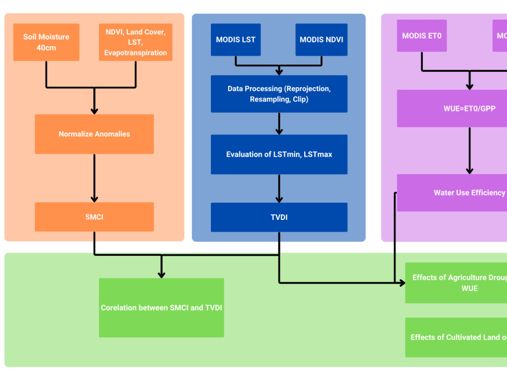
Finalization of Methodology
Methodology, expected outcomes and precautions of the Analysis