You will get GeoAI-Powered 3D City Map with Interactive Chat Assistant
Project details
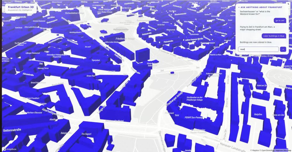
I build interactive 3D city maps that respond to natural language — not just static visualizations.
Using Mapbox GL JS for real building-height 3D rendering and an LLM with structured JSON responses, the map understands commands like "fly to downtown" or "show buildings over 100m" without any hardcoded rules. The AI interprets intent and triggers the right map action dynamically.
This combines GIS, AI and modern web mapping — a rare combination that most developers don't offer. Ideal for real estate showcases, smart city dashboards, tourism platforms, and urban planning presentations.
Using Mapbox GL JS for real building-height 3D rendering and an LLM with structured JSON responses, the map understands commands like "fly to downtown" or "show buildings over 100m" without any hardcoded rules. The AI interprets intent and triggers the right map action dynamically.
This combines GIS, AI and modern web mapping — a rare combination that most developers don't offer. Ideal for real estate showcases, smart city dashboards, tourism platforms, and urban planning presentations.
Programming Languages
HTML & CSS, JavaScript, PythonWhat's included
| Service Tiers |
Starter
$100
|
Standard
$200
|
Advanced
$400
|
|---|---|---|---|
| Delivery Time | 3 days | 5 days | 7 days |
Number of Revisions | 1 | 2 | 3 |
Design Customization | - | - | - |
Content Upload | - | - | - |
Responsive Design | - | - | - |
Source Code | - | - | - |
Optional add-ons
You can add these on the next page.
Content Upload
+$20
Responsive Design
+$20
Source Code
+$20About Tahira
Geospatial Python Developer
Frankfurt am Main, Germany - 7:19 pm local time
In my own projects, I've built road quality analyzers using OpenStreetMap data, solar potential finders, and hydrological maps — all with clean, reproducible Python code using GeoPandas, PostGIS, and Leaflet.
If you have messy geodata and need someone who can clean it, analyze it, and deliver results fast — I'm your person.
Steps for completing your project
After purchasing the project, send requirements so Tahira can start the project.
Delivery time starts when Tahira receives requirements from you.
Tahira works on your project following the steps below.
Revisions may occur after the delivery date.
Requirements Gathering
Confirm geographic area and gather requirements (data, branding, target commands)
3D Map Setup
Set up Mapbox 3D map with real building height data for the requested area