You will get Custom GIS Data Visualization using Leaflet & JavaScript

Project details
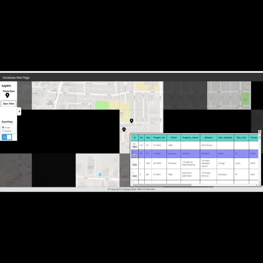
Introducing my WebGIS Project! 🌐
Successfully created a Leaflet map fetching Data from PostreSQL Database/shapefile/GeoJSON. Implemented key features such as Zoom to Layer, Markers, Layer Table creation, Point zoom, and BaseMap toggling.
Ideal for non-GIS managers to visualize data progress directly from the database, explore layers, and extract valuable information. Empower your team by tracking GIS progress seamlessly.
#WebGIS #LeafletMap #GISDevelopment"
Programming Languages
PHP, HTML & CSS, JavaScriptWhat's included $150
These options are included with the project scope.
$150
- Delivery Time 5 days
- Number of Revisions 9
About Abbas
GIS Technician / GIS Analyst / GIS Mapping
Aberdeen, United Kingdom - 11:04 am local time
I manage ESRI products ArcGIS Enterprise (ArcGIS Server) and ArcGIS Online, maintaining core datasets (address gazetteers, land/property, roads), and delivering Experience Builder, Dashboards, Survey123 apps with advanced configuration (form logic, calculations, repeats, and workflow design).
I also bring telecom delivery experience: I designed FTTH networks in QGIS and built Python automation and QGIS plugins to speed up design, reduce errors, and improve data integrity (validation tools, export/import workflows, BOM outputs, PIA JSON imports).
I can help you with:
- ArcGIS Enterprise/Server + ArcGIS Online setup, publishing, troubleshooting, and content structure.
- Experience Builder + Dashboards + Survey123 builds and improvements (advanced configuration), Leaflet
- Geodatabase management, domains/subtypes, topology rules, QA/QC, and data cleanup.
- Bringing your existing systems into GIS: linking databases, spreadsheets, CAD, and operational records to GIS layers.
- Network Analyst workflows (routing, closest facility, service areas, OD cost matrix) and network dataset prep.
- Python + SQL automation, QGIS plugin development.
- Data conversion (DWG/DXF, KML/KMZ, GeoJSON, GeoPackage).
Tools I use regularly: ArcGIS Pro/ArcMap, ArcGIS Enterprise, ArcGIS Online, QGIS, PostGIS, FME, AutoCAD, Python, SQL.
Steps for completing your project
After purchasing the project, send requirements so Abbas can start the project.
Delivery time starts when Abbas receives requirements from you.
Abbas works on your project following the steps below.
Revisions may occur after the delivery date.
Purchase the Project
Please purchase the project and send requirements
Submission of Project
I will develop Web Map as per your requirements for review.