You will get High-Precision GIS Solutions for FTTH & Utility Infrastructure
Project details
Optimize your fiber rollout with engineering-grade FTTH Network Design and Fiber Route Planning, specialize in building scalable, cost-effective infrastructure using advanced GIS spatial analysis. Leveraging experience in US-standard (Austin-based) utility projects, I ensure every cable path is optimized to reduce deployment costs
Services Include:
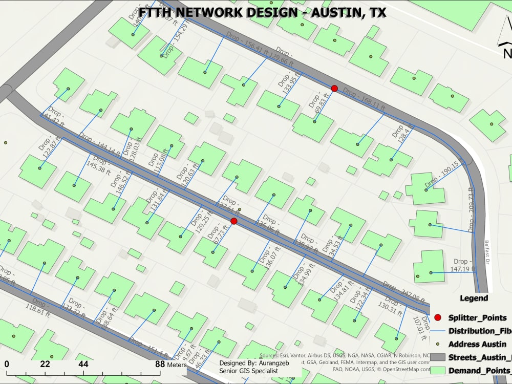
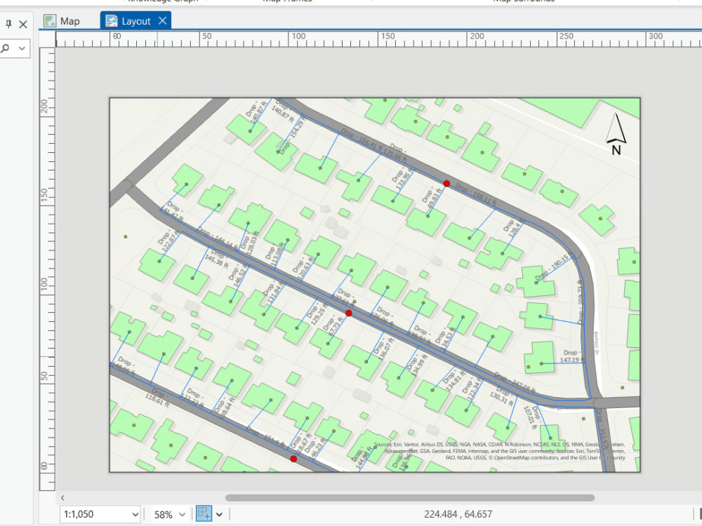
Strategic Route Planning: Optimized feeder & distribution paths for aerial or underground deployment.
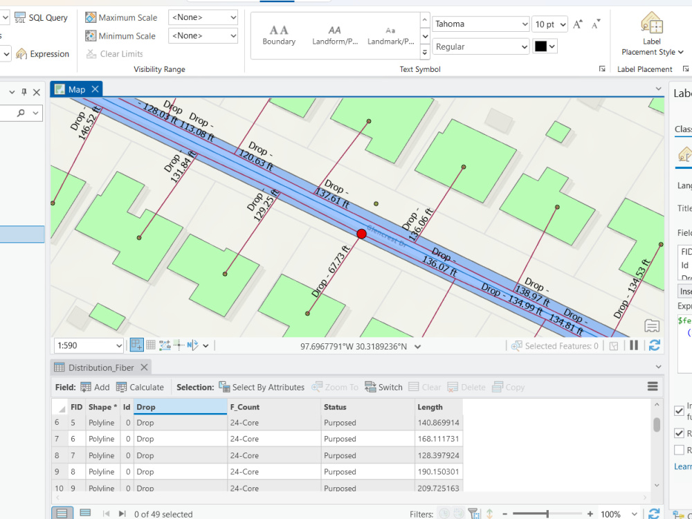
Network Architecture: High-precision mapping of OLT, Splitters, NAP points, and Splice closures.
Topology Accuracy: Clean, error-free data with zero overlaps/gaps for seamless database integration.
Engineering Deliverables: Detailed Bill of Materials (BOM/BOQ), cable length reports, and field-ready KMZ/Shapefiles.
Technical Suite:
I leverage ArcGIS Pro, QGIS, and Python to deliver high-fidelity OSP (Outside Plant) Engineering data. Whether it's a small neighborhood or a city-scale Utility GIS Database.
Ready to start immediately. Let's build a digital twin of your network!
FTTH Design, Fiber Mapping, OSP Engineering, Network Planning, ArcGIS Pro, Fiber Route Optimization, GIS Utility.
Services Include:
Strategic Route Planning: Optimized feeder & distribution paths for aerial or underground deployment.
Network Architecture: High-precision mapping of OLT, Splitters, NAP points, and Splice closures.
Topology Accuracy: Clean, error-free data with zero overlaps/gaps for seamless database integration.
Engineering Deliverables: Detailed Bill of Materials (BOM/BOQ), cable length reports, and field-ready KMZ/Shapefiles.
Technical Suite:
I leverage ArcGIS Pro, QGIS, and Python to deliver high-fidelity OSP (Outside Plant) Engineering data. Whether it's a small neighborhood or a city-scale Utility GIS Database.
Ready to start immediately. Let's build a digital twin of your network!
FTTH Design, Fiber Mapping, OSP Engineering, Network Planning, ArcGIS Pro, Fiber Route Optimization, GIS Utility.
Data Tool
ArcGISWhat's included
| Service Tiers |
Starter
$80
|
Standard
$250
|
Advanced
$600
|
|---|---|---|---|
| Delivery Time | 2 days | 5 days | 10 days |
Number of Revisions | 2 | 3 | Unlimited |
Source Code | - | - |
Optional add-ons
You can add these on the next page.
Fast Delivery
+$40 - $300
Full Topology & Connectivity Audit
(+ 1 Day)
+$50
Detailed BOQ/BOM Generation
(+ 2 Days)
+$100
Field-Ready KMZ for Mobile Apps
+$40Frequently asked questions
2 reviews
(2)
(0)
(0)
(0)
(0)
This project doesn't have any reviews.
VS
Victoria S.
Feb 9, 2026
QGIS Projects Specialist Needed
Aurang was very helpful, super responsive and completed the work I needed on time. I recommend him for any QGIS mapping projects!
DD
Darren D.
May 8, 2023
Quick job for geography (GIS) problems
About Aurang
Spatial Data Scientist | GIS Developer | GEE Dashboards & Python
New Garden Town, Pakistan - 3:24 am local time
Let’s be honest: In today’s market, location data geocoding and reverse geocoding is often the most underutilized asset in a company's toolkit. Whether you’re a Real Estate developer, a Commercial Farmer, or managing Logistics, ignoring spatial intelligence isn't just a missed opportunity. It’s a financial risk.
I don't just "make maps." I build Spatial Intelligence Systems.
With over 5 years of hands-on experience and a 100% Job Success Score, I help clients turn massive, messy datasets into clean, automated, and interactive dashboards that actually make sense for their bottom line. From calculating 21 sq km of glacier recession to building real-time crop phenology monitors for rice production, I’ve seen how the right spatial data can save millions.
✅ How I can help your business grow:
Risk Mitigation (Real Estate & Insurance): I don’t just show you a map; I analyze flood zones, terrain stability, and site suitability. I help you see the "red flags" before you commit capital.
Precision Agriculture (Ag-Tech):
I automate the boring stuff. Using Google Earth Engine (GEE), I build pipelines for NDVI and multispectral analysis so you can monitor crop health and yield without manual checking.
Operational Efficiency (Logistics & Utilities):
I optimize routes and manage assets (like FTTH or Power Plants) with sub-meter precision, cutting down fuel waste and operational lag.
Interactive Insights:
I transform decades of satellite archives into GEE Dashboards that your team can actually use to monitor changes in real-time.
🛡️ My Tech Arsenal (What I use to get results):
Cloud Power: Google Earth Engine (GEE) for large-scale time-series and LULC analysis.
Automation: Python (ArcPy, GeoPandas, Rasterio) My goal is always to turn a week’s worth of manual work into a 10-minute automated script.
Desktop GIS: ArcGIS Pro & QGIS (Expert level).
Specialized Sensing: LiDAR point cloud classification and RADAR (SAR) for flood and terrain monitoring.
Industries I’ve Empowered:
Real Estate | Precision Agriculture | NGOs & Sustainability | Urban Planning | Logistics & Safari Tourism | Mining & Energy.
I’ve delivered $12,000+ worth of complex projects by focusing on one thing: Accuracy. If your data isn't precise, it’s useless.
"If you haven't audited your spatial data yet, you're likely operating in the dark. Let’s have a quick chat and turn your location data into your biggest competitive advantage."
Steps for completing your project
After purchasing the project, send requirements so Aurang can start the project.
Delivery time starts when Aurang receives requirements from you.
Aurang works on your project following the steps below.
Revisions may occur after the delivery date.
1. Data Audit & AOI Initial Review
I begin by reviewing your area of interest (AOI) and project constraints. This includes analyzing provided boundaries, splitter ratios, and mounting requirements
2. Base Map & Infrastructure Digitization
In this phase, I extract or verify building footprints and existing utility infrastructure (poles, manholes, or underground ducts)