You will get Interactive Web Map from Your Spatial Data — Leaflet, QGIS Server, Lizmap
Project details
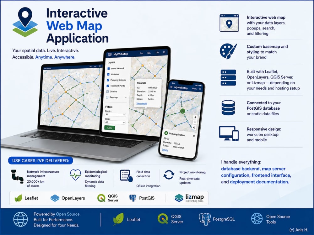
Turn your GIS data into a live, interactive web map that your team can access from any browser — no GIS software needed.
I build production-ready web mapping applications using open-source tools. In my current role, I've deployed web maps used daily by 300+ operators for sanitation network management, including an epidemiological monitoring platform built with the Ministry of Health.
WHAT I BUILD:
→ Interactive web map with your data layers, popups, search, and filtering
→ Custom basemap and styling to match your brand
→ Built with Leaflet, OpenLayers, QGIS Server, or Lizmap — depending on your needs
→ Connected to your PostGIS database or static data files
→ Responsive design: works on desktop and mobile
USE CASES I'VE DELIVERED:
• Network infrastructure management (20,000+ km of assets)
• Epidemiological monitoring with dynamic data filtering
• Field data collection dashboards (QField integration)
• Project monitoring with real-time data updates
I handle everything: database backend, map server configuration, frontend interface, and deployment documentation.
Let's discuss your project and I'll recommend the best approach.
I build production-ready web mapping applications using open-source tools. In my current role, I've deployed web maps used daily by 300+ operators for sanitation network management, including an epidemiological monitoring platform built with the Ministry of Health.
WHAT I BUILD:
→ Interactive web map with your data layers, popups, search, and filtering
→ Custom basemap and styling to match your brand
→ Built with Leaflet, OpenLayers, QGIS Server, or Lizmap — depending on your needs
→ Connected to your PostGIS database or static data files
→ Responsive design: works on desktop and mobile
USE CASES I'VE DELIVERED:
• Network infrastructure management (20,000+ km of assets)
• Epidemiological monitoring with dynamic data filtering
• Field data collection dashboards (QField integration)
• Project monitoring with real-time data updates
I handle everything: database backend, map server configuration, frontend interface, and deployment documentation.
Let's discuss your project and I'll recommend the best approach.
Programming Languages
HTML & CSS, JavaScript, PythonCoding Expertise
Cross Browser & Device Compatibility, Performance Optimization, SecurityWhat's included
| Service Tiers |
Starter
$500
|
Standard
$900
|
Advanced
$1,500
|
|---|---|---|---|
| Delivery Time | 7 days | 12 days | 18 days |
Number of Revisions | 1 | 2 | 3 |
Number of Pages | 1 | 3 | 5 |
Design Customization | - | ||
Content Upload | |||
Responsive Design | |||
Source Code | - |
Optional add-ons
You can add these on the next page.
Fast Delivery
+$100 - $150
Additional Revision
+$50
Additional Page
(+ 3 Days)
+$125
Design Customization
(+ 3 Days)
+$100
Source Code
+$100
Training session (1h video call)
(+ 3 Days)
+$80Frequently asked questions
About Anis
Senior GIS & Hydraulic Engineer | QGIS/ArcGIS PostGIS - Python | 17+ Y
Tunis, Tunisia - 4:33 am local time
As Head of GIS at Tunisia's National Sanitation Office, I designed and deployed a national-scale GIS covering 20,000+ km of sanitation networks, used daily by 300+ operators for planning, maintenance, and investment decisions. This was a €1.3M AFD-funded digital transformation project that I led from scoping through production over 5 years.
What sets me apart: I combine deep GIS/geomatics expertise with hydraulic engineering — a rare profile that lets me understand both the data infrastructure and the physical networks it represents.
WHAT I CAN DO FOR YOU:
→ Spatial Database Design & Management
PostgreSQL/PostGIS architecture, enterprise geodatabases (SDE), data migration, ETL pipelines with FME Desktop. I've designed and managed databases covering 20,000+ km of infrastructure networks.
→ Web GIS Application Development
Full-stack web mapping with Lizmap, QGIS Server, GeoServer, Leaflet, and OpenLayers. I've built production platforms including an epidemiological monitoring system and a national network management application.
→ GIS Automation & Data Processing
Python/PyQGIS scripting that reduced our spatial data processing time by 40%. Custom geoprocessing workflows, batch cartographic production, automated quality control.
→ Mobile Field Data Collection
QField/QFieldSync solutions for field teams. I designed a mobile data collection app that improved field data accuracy by 60% for 50+ field agents.
→ Cartography & Spatial Analysis
Professional thematic mapping, multi-criteria analysis for infrastructure planning, network rehabilitation prioritization. ArcGIS Pro 3.x and QGIS advanced analysis.
→ Hydraulic Modeling Integration
HEC-RAS, MIKE URBAN, EPANET, SewerGEMS — with the ability to integrate modeling results into GIS for visualization and decision support.
CREDENTIALS:
- Master's in Geomatics + Engineering Degree in Civil Engineering/Hydraulics (ENIT, Tunisia)
- 17+ years of progressive experience in GIS and infrastructure management
- 8+ donor-funded projects managed (AFD, EIB) — total budget ~€4.5M
- ISO 19115/19139/INSPIRE metadata standards expertise
- Trilingual: Arabic (Native), French (Fluent), English (Professional)
I'm available for projects worldwide and work comfortably across time zones. Let's discuss how I can help with your geospatial challenge.
Steps for completing your project
After purchasing the project, send requirements so Anis can start the project.
Delivery time starts when Anis receives requirements from you.
Anis works on your project following the steps below.
Revisions may occur after the delivery date.
Requirements and architecture design
I analyze your data and needs, then propose the best stack (Leaflet, Lizmap, or QGIS Server). You receive a wireframe and architecture plan for approval.
Development and data integration
I build the web map: backend setup, data integration, layer styling, popups, search and filter features. You receive progress updates throughout.