You will get Environmental Risk Assessment & Pre-Acquisition Due Diligence
Rising Talent
Rising Talent
Project details
Invest in land with confidence. Hidden environmental liabilities can turn a promising acquisition into a costly legal burden. As an Environmental Engineer, I provide a comprehensive Due Diligence report to safeguard your investment.
My technical approach integrates environmental data with land tenure verification. Beyond mapping, I cross-reference property data with INCRA (SIGEF/CCIR) and Land Registry Offices (Cartórios) to ensure boundaries are accurate and the ownership history is legally secure.
The assessment includes:
Regulatory Check: Active fines and embargoes from IBAMA and State agencies (SEMA).
Land Tenure: Verification through INCRA and Registry Office (Matrícula) records.
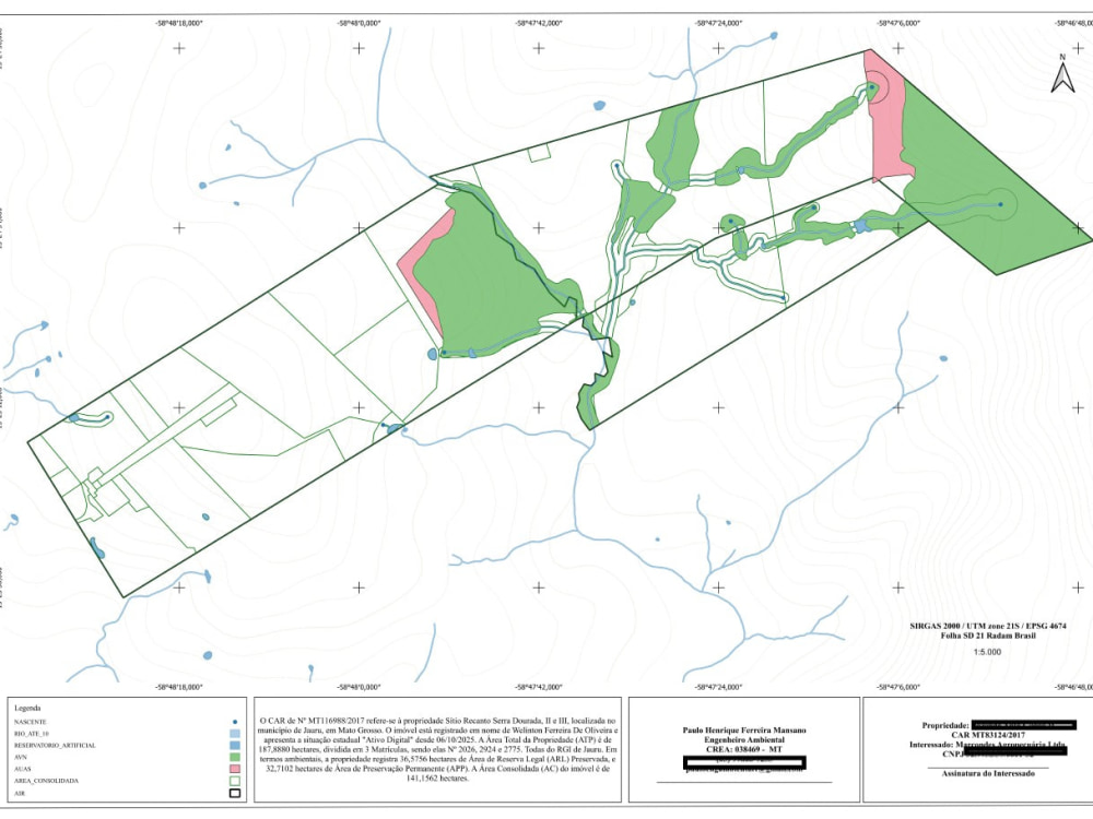
GIS Mapping: Precise delimitation of Preservation Areas (APP) and Legal Reserves.
Historical Analysis: Satellite imagery review of the last 10 years to detect illegal clearing.
Overlap Search: Checking for conflicts with indigenous lands, conservation units, or neighboring properties.
Receive a concise, data-driven technical report to verify your investment's legal and environmental health before committing your capital.
My technical approach integrates environmental data with land tenure verification. Beyond mapping, I cross-reference property data with INCRA (SIGEF/CCIR) and Land Registry Offices (Cartórios) to ensure boundaries are accurate and the ownership history is legally secure.
The assessment includes:
Regulatory Check: Active fines and embargoes from IBAMA and State agencies (SEMA).
Land Tenure: Verification through INCRA and Registry Office (Matrícula) records.
GIS Mapping: Precise delimitation of Preservation Areas (APP) and Legal Reserves.
Historical Analysis: Satellite imagery review of the last 10 years to detect illegal clearing.
Overlap Search: Checking for conflicts with indigenous lands, conservation units, or neighboring properties.
Receive a concise, data-driven technical report to verify your investment's legal and environmental health before committing your capital.
Industry
Engineering, EnvironmentalWhat's included
| Service Tiers |
Starter
$100
|
Standard
$350
|
Advanced
$650
|
|---|---|---|---|
| Delivery Time | 2 days | 4 days | 7 days |
Live Consultation (Minutes) | 0 | 0 | 0 |
Optional add-ons
You can add these on the next page.
Fast Delivery
+$50 - $300About Paulo Henrique
GIS Specialist & Environmental Engineer | Land Use Mapping
Jauru, Brazil - 11:18 am local time
I am an Environmental Engineer specializing in GIS Analysis and Remote Sensing, with a track record of transforming complex spatial data into high-stakes environmental intelligence. Since 2017, I have been at the forefront of land-use mapping and regulatory compliance in the Amazon Biome—one of the most strictly regulated and complex environments on the planet.
Currently, I am advancing my strategic vision as an MBA Candidate in Agribusiness at USP (ESALQ), the leading institution for agricultural excellence in Latin America.
Why Work With Me?
Massive Scale & Field Reality: I manage the Environmental Compliance (CAR) for a portfolio of over 450 rural properties. Unlike many GIS analysts, my work is grounded in direct, daily contact with the producers who drive the industry. I understand the operational challenges of the field, ensuring that technical compliance translates into real-world productivity and legal security.
Amazon Specialist: Deep experience navigating the technicalities of the Brazilian Forest Code, SEMA regulations, and land tenure challenges in the Mato Grosso region.
Forensic Rigor: With a postgraduate degree in Forensic Expertise, I apply a forensic mindset to every project. I treat every map as a legal document, prioritizing data transparency and scientific truth.
Tech-Driven Precision: I don’t just use tools; I build them. I develop custom QGIS plugins and Python scripts to automate complex mapping workflows, ensuring faster delivery and zero-error precision.
Core Services:
Environmental Due Diligence: Identifying liabilities, overlaps, and deforestation risks using multi-temporal satellite analysis for investors and landowners.
Advanced Mapping & Agricultural Intelligence: High-resolution Land Use classification (Sentinel, Planet) and crop monitoring to support strategic decision-making.
Forensic GIS: Detailed elevation reports, watershed analysis, and topographic mapping for infrastructure and irrigation (Center Pivot feasibility).
Compliance & ESG Strategy: Comprehensive, print-ready technical reports that align local production with international sustainability standards.
Technical Toolkit:
GIS: QGIS (Advanced/Plugin Development).
Remote Sensing: Google Earth Engine, Sentinel Hub, LiDAR processing.
Data & Automation: Python, SQL, Geoprocessing Workflows.
Whether you are an international investor seeking environmental security in Brazil or a firm needing high-precision geospatial analysis, I deliver the technical authority and the "boots-on-the-ground" insight your project demands.
Steps for completing your project
After purchasing the project, send requirements so Paulo Henrique can start the project.
Delivery time starts when Paulo Henrique receives requirements from you.
Paulo Henrique works on your project following the steps below.
Revisions may occur after the delivery date.
Data Collection & Preliminary Search
I will gather official data from primary public sources (IBAMA, State Environmental Agencies) to check for any active fines, embargoes, or legal restrictions linked to the area.
GIS Mapping & Geospatial Analysis
Using QGIS and multi-temporal satellite imagery, I will analyze land-use history, identify Permanent Preservation Areas (APP), and check for overlaps with indigenous lands or conservation units.