You will get map design, cartography, digitizing, GIS mapping, geospatial analysis.
Top Rated

Project details
I create beautiful georeferenced vector map for any goal and make geospacial analysis:
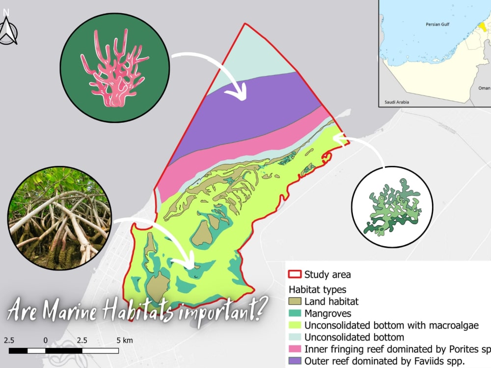
• Marine/Land habitats map
• Urban map
• Real estate map
• Survey map
• Topographical map
• Vegetation map
• Land use map
• Historic map
• Conservation map
• Marine/Land habitats map
• Urban map
• Real estate map
• Survey map
• Topographical map
• Vegetation map
• Land use map
• Historic map
• Conservation map
File Format
AI, EPS, JPG, KEY, PDF, PNG, PPT, PSDInfographic Type
GeographicWhat's included
| Service Tiers |
Starter
$25
|
Standard
$50
|
Advanced
$100
|
|---|---|---|---|
| Delivery Time | 1 day | 1 day | 2 days |
Number of Revisions | 1 | 1 | 1 |
Source Files | - | - | - |
Commercial Use | - | - | - |
Conduct Research | - | - | - |
Post to Infographic Sites | - | - | - |
51 reviews
(49)
(1)
(0)
(0)
(1)
This project doesn't have any reviews.
MJ
Muhammad J.
Jun 14, 2026
Landscape architect
great communication and quality work. worked very well with a tight deadline
CA
Cornerstone A.
Jun 12, 2026
Homebuilding Community Sales Sitemap SVG drawings: Image map / interactive map.
She did the work fast and even after I paid her came back and made a change. The maps she made look amazing!
KS
Kent S.
Jun 10, 2026
Architectural Design and Rendering
I hired this contractor for architectural elevation renderings based on their portfolio and initial responsiveness. Early communication was excellent — they were prompt, professional, and engaged. The first three design submissions showed creative promise and enough direction that I was encouraged. Despite the elevations not matching the provided floor plans or building footprint, I chose to move forward in good faith, provided a bonus for the effort, and commissioned two additional designs rather than request revisions — believing it would be more efficient to build on the momentum.
Unfortunately the engagement deteriorated significantly from that point forward:
1. INCOMPLETE SUBMISSION: The additional milestone called for two new designs. Only one was delivered.
2. NO MEANINGFUL PROGRESS: The single new submission was virtually identical to the three prior designs. None of the requested design elements from the scope were incorporated and no new direction was explored.
3. SCOPE REGRESSION: The topography that had been included in all prior submissions was completely absent from the final delivery — a clear step backward with no explanation.
4. FLOOR PLAN AND FOOTPRINT IGNORED: Throughout the entire engagement, the elevations never corresponded to the provided floor plans or building footprint. This was a fundamental requirement of the scope and was never corrected despite being raised directly.
5. AI DEPENDENCY WITHOUT COMPETENCY: Upon investigation it became clear the designs were generated entirely using AI tools rather than CAD. When confronted, the contractor first denied using AI, then walked that back by saying "the program may use it." More critically, they demonstrated no ability to make corrections, incorporate specific design elements, or align the AI output to the actual floor plans — skills that are fundamental to the scope of this work and implied by their professional representation.
6. MISREPRESENTATION: The contractor represented themselves as an architectural design professional capable of producing elevation renderings from provided floor plans and a detailed design scope. The work delivered demonstrates they lack the CAD proficiency to do so. The initial denial of AI use followed by a retraction is a further misrepresentation of their process and capabilities.
7. UNPROFESSIONAL CONDUCT: When the deficiencies were raised, rather than acknowledging the issues and offering solutions, the contractor became argumentative and dismissive. The conversation ended with them confirming they could not meet the requirements of the scope.
I remained reasonable and patient throughout — paying for all completed work, providing a bonus, and commissioning additional milestones rather than demanding revisions. The funded escrowed milestone represents payment for work that was incomplete, non-compliant with scope, and ultimately undeliverable by this contractor.
MA
Mohsen A.
Feb 25, 2026
Job 1.0: Drone P. Cloud to .rcs file to work in Civil 3D
RD
Remi D.
Feb 12, 2026
Drone Lidar process
Good job, thanks
About Liubov
GIS/CAD Engineer|Lidar data processing |Map design| Ecologist
99%
Job Success
Dubai, United Arab Emirates - 2:55 am local time
I'm offering the following services:
✔LIDAR, drone, point cloud data processing and analysis: • DEM, DSM, DTM, contours • Surface generation • Classification • 3D mesh model • Orthophoto • Volume calculation • Multispectral analysis • Solar panels & power lines inspection
✔Architectural: • 3D modelling • 3D Rendering • Landscape design • BIM modelling
✔Digital mapping 2D and 3D: • Vegetation • NDVI • Topographical • Historical • Urban • Environmental • Marine habitat • Geology • Power lines clear zone (vegetation occurence, height) • Heat (interpolation of parameters) • Agriculture map • Detection of animals
✔CAD: • Topographical plan • Site plan • Floor plan • Elevation plan • Construction plan
✔Laser scanning, terrestrial scanning processing: • Registration • Point cloud analysis • 3D modelling
✔Satellite imagery processing: • NDVI • Vegetation identification and change detection • Machine learning algorithms for analysis• Oil spills detection
✔Out-of-the-box tasks which require problem solving in the field of surveying, ecology and geospatial technologies
Steps for completing your project
After purchasing the project, send requirements so Liubov can start the project.
Delivery time starts when Liubov receives requirements from you.
Liubov works on your project following the steps below.
Revisions may occur after the delivery date.
Creating map
Creating map based on your request