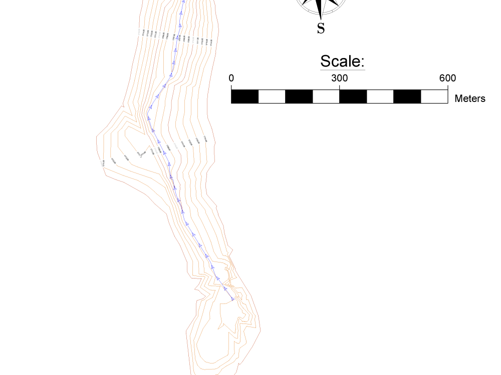
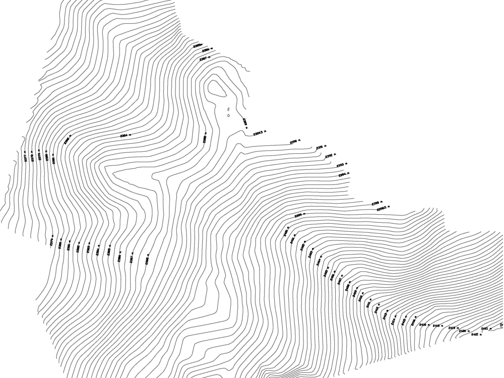
You will get TIN surface contours from your survey data in Civil 3D
Project details
You will get a TIN or Grid surface depending on your preference. My preference is usually a TIN surface developed using AutoCAD Civil 3D.
I have over seven years of experience working with survey data to build contour surfaces that reflect the natural environment. I have experience in cleaning or refining the surface in the event that only sparse point data is available and can edit the surface itself based on your requirements.
I look forward to helping you develop a professional contour surface from your survey data.
I have over seven years of experience working with survey data to build contour surfaces that reflect the natural environment. I have experience in cleaning or refining the surface in the event that only sparse point data is available and can edit the surface itself based on your requirements.
I look forward to helping you develop a professional contour surface from your survey data.
Type
Commercial, Industrial, ResidentialFile Format
DWG, OBJ, TIFF, JPG, PDFSoftware
Autodesk AutoCAD, AutoCAD Civil 3D, Autodesk Civil 3DWhat's included
| Service Tiers |
Starter
$50
|
Standard
$75
|
Advanced
$100
|
|---|---|---|---|
| Delivery Time | 1 day | 3 days | 5 days |
Number of 2D Drawings | 1 | 2 | 3 |
Number of Revisions | 3 | 6 | Unlimited |
High Level of Details | - | ||
Source File | - | ||
Graphic Enhancements | - | ||
Layout Sheets | - | - |
Optional add-ons
You can add these on the next page.
Fast Delivery
+$25 - $40
Additional 2D Drawing
(+ 1 Day)
+$20
Additional Revision
+$20
Additional Sq. Ft.
+$10
High Level of Details
(+ 1 Day)
+$30
Source File
+$10
Graphic Enhancements
+$10
Layout Sheets
(+ 1 Day)
+$15
14 reviews
(13)
(1)
(0)
(0)
(0)
This project doesn't have any reviews.
XC
Xanthos C.
Jun 19, 2026
3D Site Mapping Services for Excavation and Backfill Levels
BA
Brandon A.
Jan 16, 2026
Drone Functional Requirements and Scoping
Joe was very helpful with our project and helping understand the requirements and solutions.
MA
Mansha A.
Jan 20, 2025
Civil 3D topographer to generate DEM maps using Public/Private LIDAR dataset for Hydrologic study
It was my pleasure to have hired and worked Joe. He was always available to provide his services at a short notice, I will continue to go back to Joe for his expertise in LIDAR field.
RW
Rickman W.
Sep 15, 2024
Lidar Data (DJI M350, L1 Sensor) Processing/Conversion for SketchUp - Residential Lot (.5 Acres)
Two thumbs up for Joe. I will work with him again.
LF
Liliana F.
Jun 24, 2024
Create road longitudinal section using 50cm contour lines
Very happy with Joe's work and communication.
About Joe
Civil 3D Engineer -(LiDar-Drone-Survey/Topography/Earthworks)
100%
Job Success
Nanyuki, Kenya - 11:24 am local time
📋I am a Civil Engineer with over 10 years of professional experience spanning countries including; the United Kingdom (UK), United States (US), Australia, Germany, Latvia, Greece, Portugal, Somalia, Kenya, and Tanzania. This includes developing & analysing topography & earthworks from traditional and aerial survey data, as well as designing earth embankment dams in the construction, renewables, and horticulture sectors. My passion lies in solving issues regards Civil 3D surface terrain (contours) modelling & optimization using photogrammetry (aerial drone photos, point clouds, & LiDar) and traditional survey data.
Let me help you develop;
✅Material Volume Maps (Cut/Fill, Elevation Banding, Custom Quantities) using Laser Scan or Drone LiDar/point clouds RTK survey, or Total Station survey data
✅Topographical surface contours & map development and visualizing complex topographical information.
✅Road & Surface Profiles/Cross Sections using Civil 3D/C3D TIN surfaces (Alignment Creation + Multiple Profile Views + Plan View of Alignment)
✅Embankment Dams/Ponds/Pans/Lagoons using Civil3D/C3D (Design grading, reservoir storage estimates (stage storage), earthworks (TIN surface volume)
✅Digitizing & Georeferencing Maps (GeoTiff) including CAD drawings, Land Parcel/Title/Boundary Surveys, Paper copy, As-built, Cadastral, & Scanned Maps using Global Mapper & Civil 3D/C3D
✅Laser scan/LiDar Point Cloud (.RCP/.RCS/.Laz/.Las/.zLas/.cl3/.ply/.koo/.txt/.e57) to CAD (dwg/dxf)
✅LiDar/DTM to Civil 3D TIN surface conversion.
✅Photogrammetry including; Georeferenced Aerial Photo/Image Overlay, Point Cloud Segmentation, Orthomosaic/Orthophotos, and Digital Elevation (DEM)/Terrain(DTM)/Surface (DSM) Models
✅CAD maps (.dwg or .dxf) into Google Earth (.kml or .kmz), and
Key Software packages include:
🧰AutoDesk AutoCAD
🧰AutoDesk Civil 3D
🧰Golden Software Surfer (CAD software)
🧰Blue Marble Global Mapper Pro (GIS)
🧰AutoDesk (ReCap) Reality Capture Pro
🧰Modri Planet 3D Survey (Photogrammetry)
🧰Agisoft Metashapes/Photoscan (Photogrammetry)
🧰Google Earth Pro
Topographical skills include:
🛠3D surfaces
🛠Earthwork analysis (Cut/Fill maps & quantities/surface comparisons)
🛠Stage Storage (water storage estimation)
🛠Survey point; import/ point group optimization
🛠TIN Surface contour development (from survey points/ point clouds/ polylines)
🛠DTM's (Digital Terrain Models) and DSM (Digital Surface Model) production and editing
🛠TIN (Triangulated Irregular Network) surface creation and editing
🛠Civil 3D point group sorting
🛠Surface profiles (single and multiple profiles)
🛠Catchments and flow paths
🛠Raster(image), surface, and shapefile connections
🛠Digitizing scanned maps (Georeferemcing, AutoDesk Rubber Band, pdf to CAD drawings)
🛠CAD (dwg, dxf) to; Google Earth (KML,KMZ),shape file (.shp) conversion, .pdf, and image (JPEG, TIFF, PNG)
Photogrammetry skills include:
📷Bundle adjustment
📷Dense point cloud reconstruction
📷Point clouds (Development, Import, Export, TIN surface development)
📷Orthomosaics production for 500 to 2,000 images
📷Digital surface models
📷DEM's (Digital Elevation Models) and DTM's (Digital Terrain Models)
📷Contour development from DEM's
📷Exporting georeferenced TIFF and JPEG images viewable in Google Earth
📷Exporting contours or DEMS
📷Alignment of photos using ground control points
📷CAD drafting over exported data
I am here to provide solutions. Reach out and let’s discuss it.
Thanks,
Joe
Steps for completing your project
After purchasing the project, send requirements so Joe can start the project.
Delivery time starts when Joe receives requirements from you.
Joe works on your project following the steps below.
Revisions may occur after the delivery date.
Data received from the client, and processing or data clean up commenced.
I will import the survey data ain Civil 3D if it is in a format that can be read by the software. Will develop point groups, and then develop the surface.
Refining surface
I will refine the surface based on experience or feedback from the client.