You will get expert multitemporal change detection: urban growth and land-use evolution
Project details
Unlock historical satellite insights with expert Geospatial Analysis.
Need to quantify urban sprawl, deforestation, or land-use changes over decades? I provide high-precision Multitemporal Change Detection using Google Earth Engine (GEE) to process massive datasets (Landsat/Sentinel) in record time.
What I deliver:
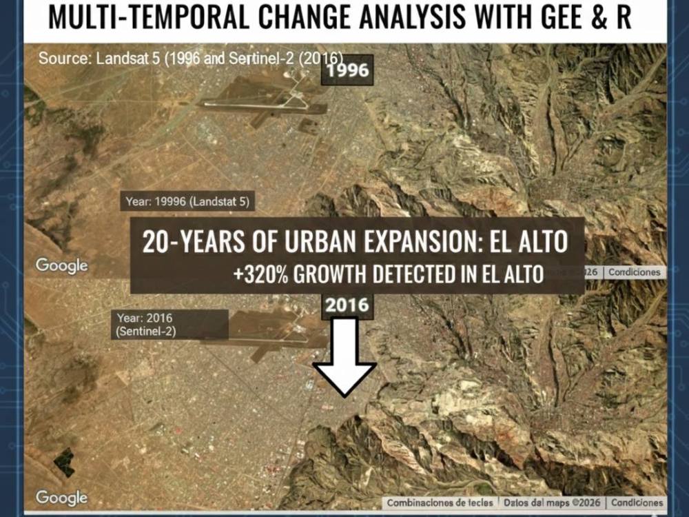
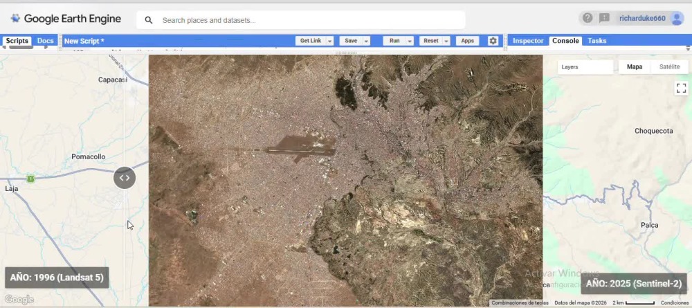
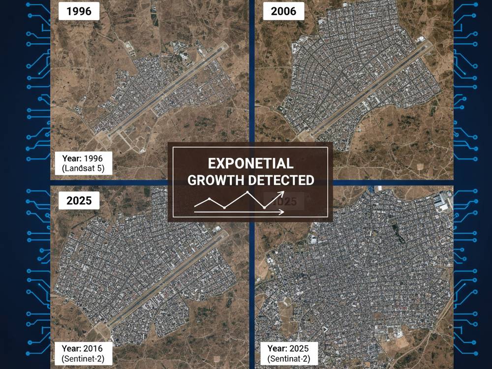
Time-Series Analysis: Detailed evolution of your area from 1984 to 2024.
Precision Mapping: High-res maps identifying exactly where and when transitions occurred.
Statistical Data: Accurate area calculations (ha/km²) and growth rates validated in R.
Sensor Fusion: Integration of Optical and Radar (Sentinel-1/SNAP) data for cloud-prone areas.
Deliverables:
High-Res Maps: (PDF, GeoTIFF, PNG) for professional reports.
Technical Report: Insights on trends and expansion patterns.
GIS Files: Shapefiles/KML ready for QGIS or ArcGIS Pro.
As a Geographic Engineer, I use scientifically backed algorithms (Random Forest, NDVI/NBR) to ensure engineering-grade results.
Let’s transform satellite data into actionable intelligence.
Need to quantify urban sprawl, deforestation, or land-use changes over decades? I provide high-precision Multitemporal Change Detection using Google Earth Engine (GEE) to process massive datasets (Landsat/Sentinel) in record time.
What I deliver:
Time-Series Analysis: Detailed evolution of your area from 1984 to 2024.
Precision Mapping: High-res maps identifying exactly where and when transitions occurred.
Statistical Data: Accurate area calculations (ha/km²) and growth rates validated in R.
Sensor Fusion: Integration of Optical and Radar (Sentinel-1/SNAP) data for cloud-prone areas.
Deliverables:
High-Res Maps: (PDF, GeoTIFF, PNG) for professional reports.
Technical Report: Insights on trends and expansion patterns.
GIS Files: Shapefiles/KML ready for QGIS or ArcGIS Pro.
As a Geographic Engineer, I use scientifically backed algorithms (Random Forest, NDVI/NBR) to ensure engineering-grade results.
Let’s transform satellite data into actionable intelligence.
Database Type
PostgreSQLWhat's included
| Service Tiers |
Starter
$50
|
Standard
$120
|
Advanced
$250
|
|---|---|---|---|
| Delivery Time | 2 days | 4 days | 7 days |
Number of Revisions | 1 | 2 | Unlimited |
Schema Diagram | - | - | - |
Permissions Setup | - | - | - |
Import/Export Data | - | - | |
Admin Panel Setup | - | - |
Optional add-ons
You can add these on the next page.
Import/Export Data
(+ 1 Day)
+$50
GEE Source Code Delivery
+$50Frequently asked questions
About Richard
GIS & Remote Sensing Engineer | Google Earth Engine Expert | Python,R
La Paz, Bolivia - 7:49 am local time
Deje de esperar semanas para el procesamiento de datos satelitales. Me especializo en la automatización de análisis geoespaciales complejos con Google Earth Engine (GEE) , lo que proporciona resultados de alta precisión en tiempo récord.
Como ingeniero geográfico , ayudo a los clientes a transformar imágenes satelitales sin procesar en inteligencia procesable para la agricultura, la planificación urbana y el monitoreo ambiental.
Mi stack técnico incluye:
Inteligencia satelital: experto en datos GEE, SNAP y Sentinel/Landsat.
Software SIG: conocimiento avanzado en QGIS y ArcGIS Pro.
Ciencia de Datos y Bases de Datos: Análisis espacial con R y Python , y gestión de bases de datos con PostgreSQL/PostGIS .
Lo que entrego:
Agricultura: Monitoreo preciso de NDVI/EVI e informes sobre la salud de los cultivos.
Topografía e hidrología: procesamiento DEM de alta resolución (ALOS PALSAR), líneas de contorno y delimitación de cuencas hidrográficas.
Detección de cambios: análisis multitemporal del crecimiento urbano o la deforestación.
Me comprometo con el rigor científico y la comunicación técnica clara. Hablemos sobre cómo puedo aportar valor a tu proyecto.
Steps for completing your project
After purchasing the project, send requirements so Richard can start the project.
Delivery time starts when Richard receives requirements from you.
Richard works on your project following the steps below.
Revisions may occur after the delivery date.
Data Acquisition & Pre-processing.
Filtering Landsat/Sentinel collections in GEE and atmospheric correction
Algorithm Implementation.
Execution of scripts for change detection or index calculation (NDVI/NBR)