You will get a cutting edge GIS apps & web ASP.NET full-stack with LOW PRICE + LIFETIME


Project details
BASIC: GIS Essentials
Start your GIS journey with essential tools and functionality. Includes basic spatial analysis, WebGIS creation, and interactive maps.
Spatial Analysis: Basic analysis using popular GIS tools.
WebGIS: Interactive map creation with standard tools.
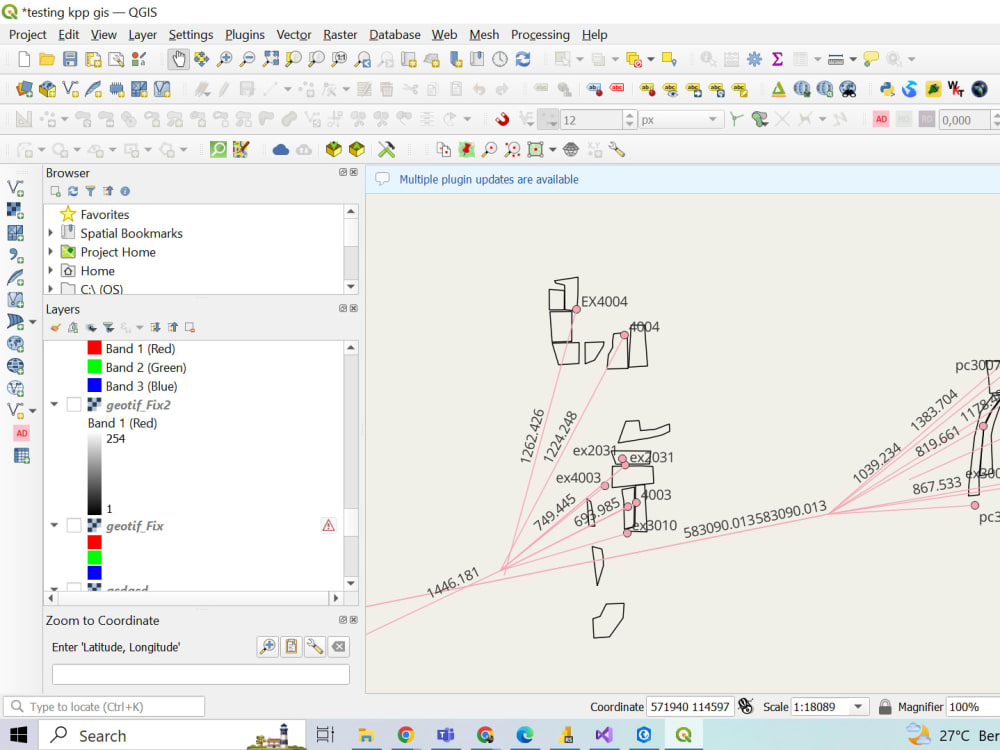
Software Used: QGIS, ArcGIS, HTML, CSS.
Support: 1 Month
STANDARD: GIS Pro
A comprehensive GIS solution with advanced spatial analysis, 3D modeling, and custom dashboard development.
Spatial Analysis & Queries: Advanced spatial analysis with tailored spatial queries.
3D Modeling & Thematic Mapping: Creation of 3D models and thematic maps.
Dashboard Development: Custom dashboard using R or Power BI.
Remote Sensing: Raster Analysis & Visualizations.
Software Used: QGIS, ArcGIS, RStudio, Power BI, Python.
Support: 3 Months
PREMIUM: GIS Elite
The ultimate GIS package with top-tier spatial modeling, real-time WebGIS, cutting-edge remote sensing, and lifetime support.
Spatial Training & Modeling: Utilizing Python for advanced spatial training & modeling.
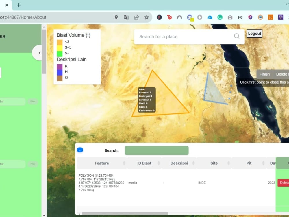
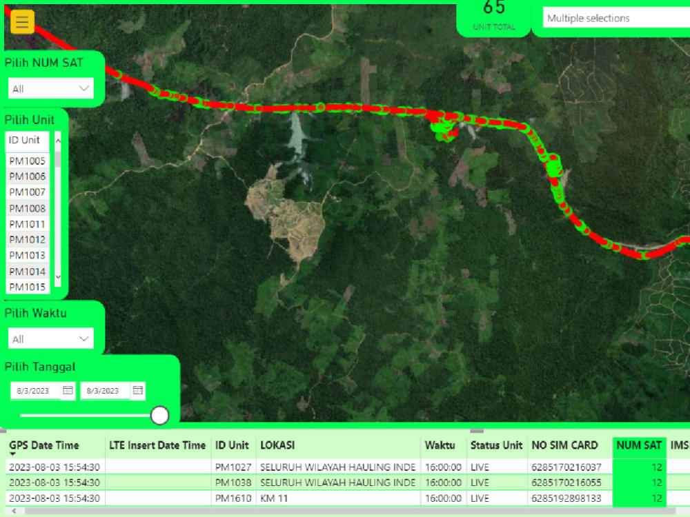
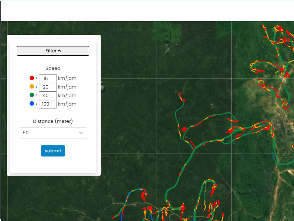
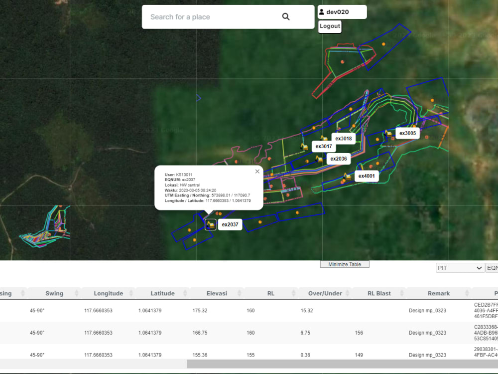
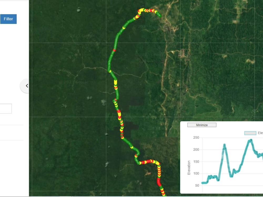
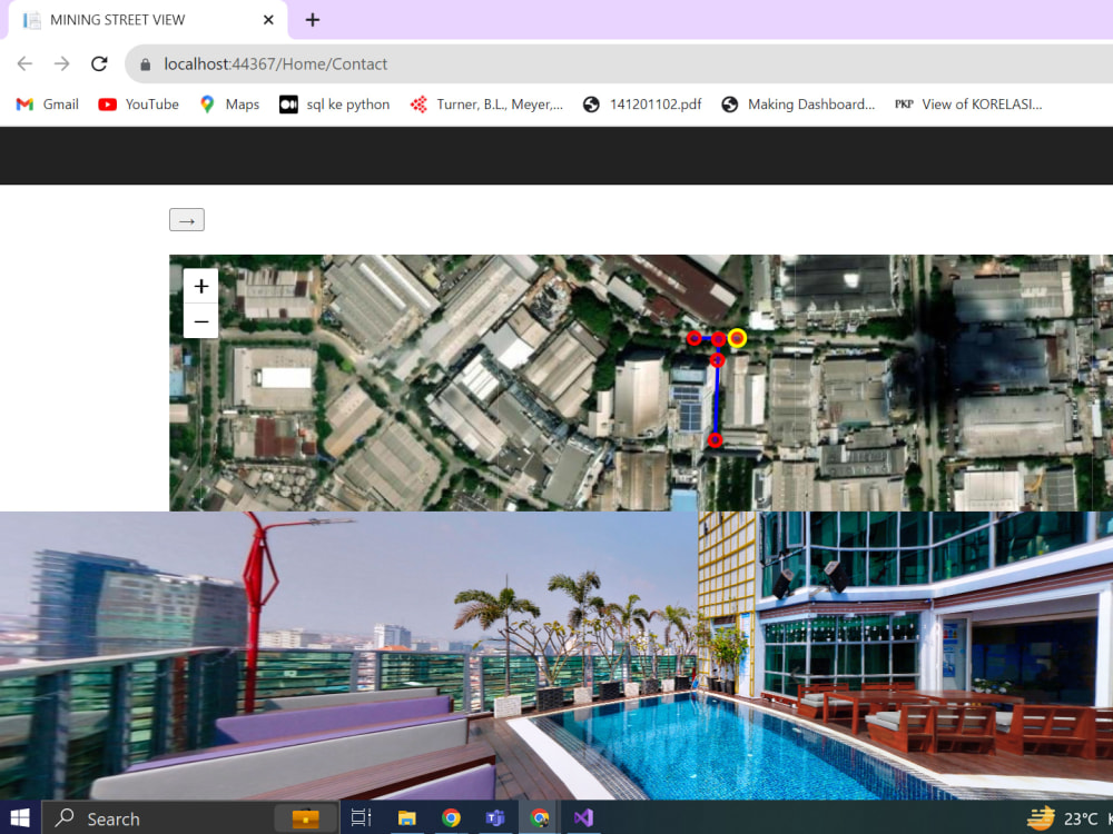
Real-time WebGIS: Creating real-time interactive maps with ASP.NET
Cutting-edge Remote Sensing: Advanced satellite imagery
Software Used: ASP.NET C# Js
Suport: 1 Year
Start your GIS journey with essential tools and functionality. Includes basic spatial analysis, WebGIS creation, and interactive maps.
Spatial Analysis: Basic analysis using popular GIS tools.
WebGIS: Interactive map creation with standard tools.
Software Used: QGIS, ArcGIS, HTML, CSS.
Support: 1 Month
STANDARD: GIS Pro
A comprehensive GIS solution with advanced spatial analysis, 3D modeling, and custom dashboard development.
Spatial Analysis & Queries: Advanced spatial analysis with tailored spatial queries.
3D Modeling & Thematic Mapping: Creation of 3D models and thematic maps.
Dashboard Development: Custom dashboard using R or Power BI.
Remote Sensing: Raster Analysis & Visualizations.
Software Used: QGIS, ArcGIS, RStudio, Power BI, Python.
Support: 3 Months
PREMIUM: GIS Elite
The ultimate GIS package with top-tier spatial modeling, real-time WebGIS, cutting-edge remote sensing, and lifetime support.
Spatial Training & Modeling: Utilizing Python for advanced spatial training & modeling.
Real-time WebGIS: Creating real-time interactive maps with ASP.NET
Cutting-edge Remote Sensing: Advanced satellite imagery
Software Used: ASP.NET C# Js
Suport: 1 Year
Programming Languages
JavaScript, ASP.NET, C#Coding Expertise
Cross Browser & Device Compatibility, Performance Optimization, SecurityWhat's included
| Service Tiers |
Starter
$50
|
Standard
$80
|
Advanced
$100
|
|---|---|---|---|
| Delivery Time | 2 days | 7 days | 14 days |
Number of Revisions | 2 | 5 | 9 |
Number of Pages | 5 | 10 | 17 |
Design Customization | |||
Content Upload | - | - | |
Responsive Design | - | ||
Source Code |
Optional add-ons
You can add these on the next page.
Lifetime Support
(+ 1 Day)
+$10
5 reviews
(4)
(0)
(0)
(0)
(1)
This project doesn't have any reviews.
AK
Andrew K.
Nov 10, 2025
Proposal for Development of Google Earth Engine Applications
Rz
Raef z.
Nov 5, 2025
frontend backend app_cad simulation
ST
Shanti T.
Aug 7, 2024
Travel Recommendation
KT
Kevin T.
Sep 26, 2023
Google Earth Engine Code To Pull Data For Area of Interest
Dipo did a great job completing the task. Very prompt, professional and followed-up to make sure there were not any issues.
TM
Toby M.
Aug 20, 2023
Data analyst/BI to convert simple dataset into bubble map visualisation
Dipo produced a high quality of work and was responsive to all feedback. We collaborated well over different timezones and he completed the work within a short period. Will like hire again.
About Dipo
GIS/RS Developer & Analyst | GeoAI & Spatial Data Science | Engineer
67%
Job Success
Jakarta, Indonesia - 8:44 pm local time
Hello everyone, thank you for visiting my profile, my name is Dipo Rizki Saleh. I'm a graduate of Geography, Faculty of Mathematics and Natural Science Universitas Indonesia that passionate about GIS, Remote Sensing, Spatial Data Science, Data Visualization, R programming, Business Development, and Digital Marketing that have 2 years of college-work experience in small companies and ventures and 1+ years (ongoing present-time) of industry-work experience in big corporate. I have skills in spatial analysis, statistical analysis, satellite imagery, GIS architecture, survey and mapping, and programming using ASP.NET C#, javascript, R, Python, and SQL. I am also familiar with various frameworks, including Tensorflow, Numpy, React.js, and Node.js for data science and modeling needs. With my background in GIS, remote sensing, and spatial data science alongside business development, I can help the company to achieve its goal of expanding into new markets and improvising its development, especially in spatial analytical needs. Whether the company is a plantation/mining/logistic/environment/retail/oil&gas or other related industries.
Technical Competency/Expertise:
- Geographic Information System (GIS) : Spatial Analysis, Thematic Mapping, WebGIS, Google Earth Engine, Dashboard Development (R), Spatial Queries, Spatial Data Management
- Remote Sensing : Raster Analysis & Visualizations, Spatial Training & Modeling (Python), Indices Algorithm, Satellite Imagery, 3D Modeling
- Survey and Mapping : Land/Topographic Survey, Surveying instrument (Theodolite, RTK, and GPS)
- Business: Digital Marketing, Business Development & Improvement, Entrepreneurship, General Geography
* Software/Language Used: QGIS, ArcGIS (All Products), RStudio, Jupyter, AutoCAD, ENVI, GEE, Tableau, Power BI / R, Python, SQL, Javascript, HTML, CSS
Soft skills:
- Leadership, team-working
- Good English proficiency
- Management, growth-mindset
Hobbies:
- Watching movies, playing games
- Going hangout with friends
- Culinary and coffee/drinks enthusiast
MBTI: Commander (ENTJ-A)
Steps for completing your project
After purchasing the project, send requirements so Dipo can start the project.
Delivery time starts when Dipo receives requirements from you.
Dipo works on your project following the steps below.
Revisions may occur after the delivery date.
GIS Full-Stack Development
I will start develop as soon as the clients require