You will get a professional interactive web map, various widgets, ESRI's SDKs
Top Rated

Project details
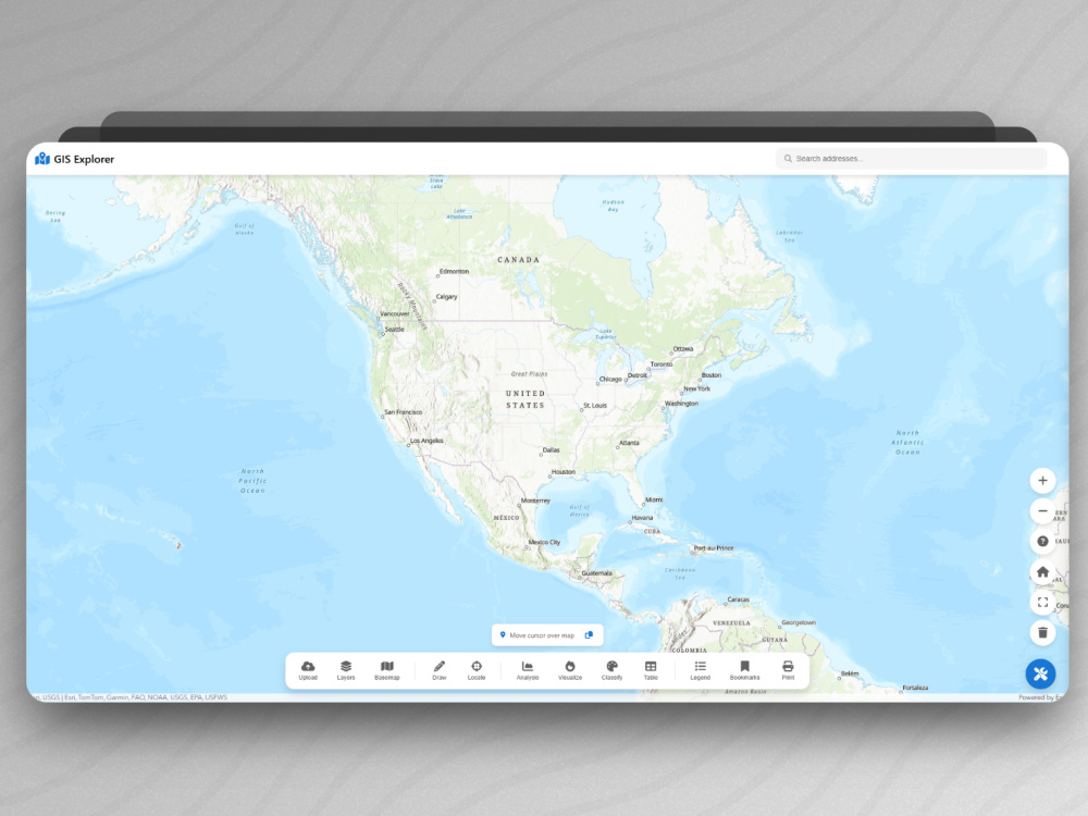
Interactive Maps using ArcGIS API for JavaScript:
What about a map you can click and display features and fillter on what will display on the map, etc. I am expertise in creating interactive maps using ESRI's SDKs JavaScript and will be happy to help.
I created lot of interactive maps using ArcGIS API for JavaScript from different sources data such as feature layers, Excel sheets, shapefiles, geojsons, etc.
Programming Languages
HTML & CSS, JavaScriptCoding Expertise
PSD to HTML, Localization, DesignWhat's included $190
These options are included with the project scope.
$190
- Delivery Time 2 days
- Number of Revisions Unlimited
- Number of Pages 1
- Design Customization
- Content Upload
- Responsive Design
- Source Code
34 reviews
(32)
(1)
(1)
(0)
(0)
This project doesn't have any reviews.
DD
Darren D.
Jun 2, 2026
GIS developer
Ashraf did an outstanding job creating GIS maps for my project. From the beginning, he demonstrated a strong understanding of spatial data, cartographic design, and the technical requirements I needed. He was able to take complex datasets and turn them into clear, visually appealing, and highly functional maps that were exactly aligned with my goals. His attention to detail and accuracy really stood out, especially when working with layered data and ensuring everything was properly georeferenced and formatted.
Beyond the technical quality of the work, Ashraf was very professional and easy to communicate with throughout the entire process. He responded quickly, asked the right clarifying questions, and made revisions promptly whenever needed. The final deliverables were high-quality and ready to use without any issues. I would highly recommend Ashraf to anyone looking for reliable and skilled GIS work, and I would absolutely work with him again on future projects.
Beyond the technical quality of the work, Ashraf was very professional and easy to communicate with throughout the entire process. He responded quickly, asked the right clarifying questions, and made revisions promptly whenever needed. The final deliverables were high-quality and ready to use without any issues. I would highly recommend Ashraf to anyone looking for reliable and skilled GIS work, and I would absolutely work with him again on future projects.
NH
Ngala H.
May 8, 2026
I need someone to create a new layer that has distance between two layers in qgis
NA
Nissie A.
May 7, 2026
GIS Analyst (Healthcare Access / Drive-Time Analysis – ArcGIS Network Analyst Required)
If you’re reading through similar profiles in the GIS space like I was, trying to find the right person to work with, you can choose this profile. Ashraf was EXCEPTIONAL in his service. He went out of his way repeatedly to ensure we get the best results. He was easily reachable, and would always follow up on my feedback and our conversations. He was patient when I made a fault with the data. Went ahead and re-did that analysis with the new data!!! I would give Ashraf 10 stars if I could. He was the ultimate combination of skills + great attitude. I will definitely be working with him again.
So like I said, if you’re looking for a great, skillful person to hire, Ashraf is your guy. Look no further!
So like I said, if you’re looking for a great, skillful person to hire, Ashraf is your guy. Look no further!
MW
Max W.
Nov 13, 2025
Map Creation for Scientific Paper
Ashraf is a very helpful and competent person. Highly recommend hiring him!
OL
O L.
Oct 9, 2025
data collection
Responsive, competent, great to work with.
About Ashraf
GIS Solutions Engineer | ESRI's GeoAI
100%
Job Success
Cairo, Egypt - 5:30 am local time
Thank you for visiting my profile. With over three years of dedicated experience in Geographic Information Systems (GIS), I specialize in solving spatial challenges through precise and innovative GIS solutions. My expertise spans GIS Development, Spatial Analysis, and Data Visualization, ensuring that I can deliver exceptional results for your project goals.
I help businesses and researchers turn geospatial data into clear, accurate, and actionable insights. I specialize in ArcGIS Pro, GeoAI deep learning, remote sensing, spatial analysis, and building interactive GIS web apps.
Skills:
• ArcGIS Enterprise (Online, Portal, Server)
• Desktop GIS (ESRI Suite - ArcGIS Pro. QGIS)
• ArcGIS API for JavaScript.
• Python (ArcPy)
• GIS Development
• Geocoding
• ESRI's GeoAI (Detect Objects Using Deep Learning)
• Geolocation & Data Collection
• Georeferencing & Vectorization
• Spatial Querying & Mapping
• Spatial Data Analysis
• Spatial Data Science
• ESRI ModelBuilder
• Data Visualization
• Spatial Problem Solving
• Cartography
• Leaflet.js
• LiDAR and Point Clouds Processing
• Google Earth Pro
• ERDAS Imagine
• Remote Sensing
Key Services:
• Interactive Maps Development
• Creating Shapefiles
• Georeferencing Scanned Maps
• Network Analysis
• Coordinates Extraction
• Heat Map Creation
• Satellite Image Processing
• Geocode Addresses
My focus is not just on completing tasks, it's about fostering growth and building lasting partnerships with my clients. As a fast learner who thrives on problem-solving, I remain dedicated to helping you achieve your goals. I view every project as an opportunity to build a collaborative partnership rather than merely completing a task. Understanding your unique needs and objectives is foundational to delivering tailored solutions that exceed expectations.
Let's connect!
Steps for completing your project
After purchasing the project, send requirements so Ashraf can start the project.
Delivery time starts when Ashraf receives requirements from you.
Ashraf works on your project following the steps below.
Revisions may occur after the delivery date.
Data collection if not found and cleaning it.
through this step, I will listen to the goal and the requirements and then collect the necessary data and processing it to start implement it in the project.
Starting writing the code.
in this step, I will starting writing the code and I will use the ArcGIS API for JavaScript at this project.