You will get AI-driven Crop Monitoring and Crop Productivity analysis (Satellite based)
Top Rated
Project details
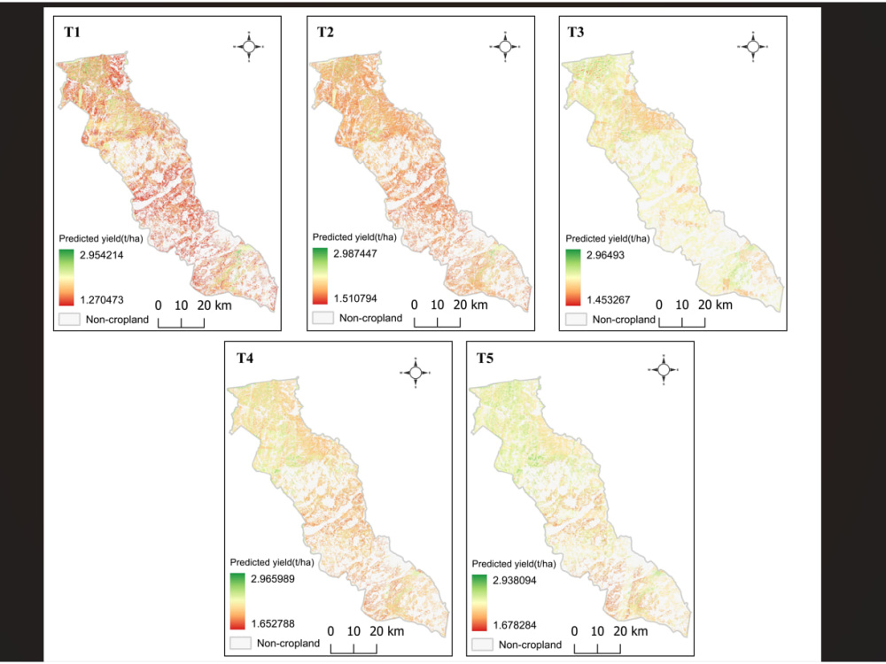
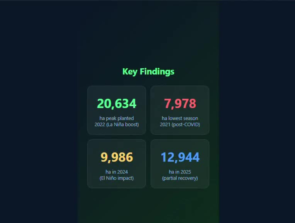
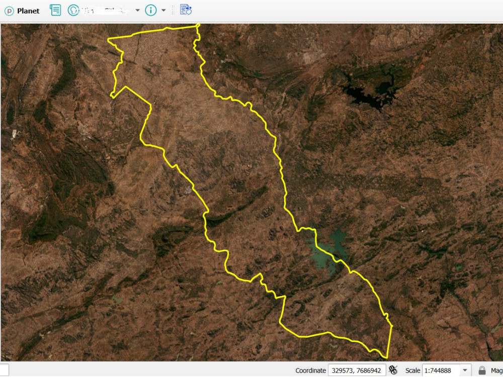
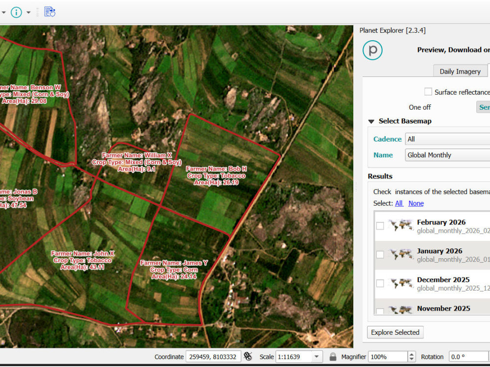
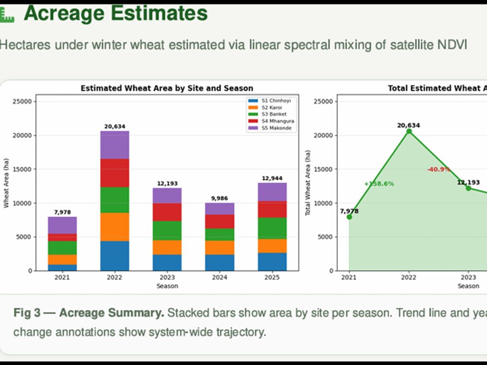
you will a transformation of raw remote sensing/ satellite imagery data into actionable agricultural intelligence, providing high-accuracy field boundary mapping and machine learning-driven crop yield predictions to support food security initiatives and data-driven farming decisions. I fuse high-precision micro-level mapping (sub-meter field boundaries) with macro-level AI predictive modeling. Rather than just delivering raw data or generic maps, I engineer scalable pipelines in GEE and Python that translate complex satellite data into stakeholder-ready insights. My approach ensures that the geospatial intelligence directly answers the client's core operational questions—whether for humanitarian food security (like WFP standards) or commercial yield forecasting. Key steps in my project is:
1. Selection of Satellite data, definition of Area of Interest,
2. Analysis Environment set up and Data Acquisition - Satellite and in-situ ancilliary crop data
3. Image processing and analysis
4. Agricultural statistics and products generation (maps, tables, graphs)
5. Report writing
1. Selection of Satellite data, definition of Area of Interest,
2. Analysis Environment set up and Data Acquisition - Satellite and in-situ ancilliary crop data
3. Image processing and analysis
4. Agricultural statistics and products generation (maps, tables, graphs)
5. Report writing
AI Development Type
Deep Learning, Knowledge Representation, Model Tuning, Recommendation SystemAI Tools
Keras, MATLAB, NVIDIA AI Platform, PyTorch, TensorFlowAI Development Language
PythonWhat's included
| Service Tiers |
Starter
$350
|
Standard
$750
|
Advanced
$1,500
|
|---|---|---|---|
| Delivery Time | 3 days | 5 days | 8 days |
Number of Revisions | 2 | 2 | 3 |
AI Model Integration | |||
Detailed Code Comments | - | ||
Knowledge Graph | - | - | - |
Model Documentation | - | ||
Ontology | - | - | - |
Source Code | - | ||
Taxonomy | - | - | - |
4 reviews
(4)
(0)
(0)
(0)
(0)
This project doesn't have any reviews.
MW
Muhammad W.
Mar 17, 2026
To perform a structural and topographic analysis for a 5km x 5km area of interest
Isaxon is an expert in handling complicated tasks, I interacted with him on a project of geological "structures mapping from SAR imagery" and he was above my expectations. Excellent, recommended to everyone
MW
Muhammad W.
Mar 12, 2026
Thermal Anomaly Mapping and Raw LST Data Extraction (Landsat 8/9)
Very experienced and knowledgeable, skills are up to the mark, performed job on time
LS
Liron S.
Sep 25, 2025
Georef and digitze pdfs
Isaxon demonstrated strong proficiency and a clear commitment to the tasks assigned. I recommend him and would be happy to hire him again for future projects.
CT
Carlene T.
Aug 13, 2025
Greenfield land mapping
The project was completed on time and successfully.
About Isaxon
GIS & Remote Sensing Specialist | ArcGIS Pro | QGIS | GeoAI
100%
Job Success
Harare, Zimbabwe - 7:34 am local time
I am an experienced GIS & Remote Sensing specialist with 8 years+ experience in GIS, GNSS end-to-end, Digitization, vectorization, Georeferencing, Spatial Data Entry & Spatial data cleaning, Cartography, Photogrammetry, LiDAR point clouds, Geospatial data processing (vector and raster) using plaforms/softwares such as ArcGIS Pro, Google Earth Engine, QGIS, ENVI, Pix4D, Global Mapper and PostGIS for Geodatabase management.
I excel as a consultant because I am a very Clear Communicator who is always Detail Oriented thus I am Accountable for every outcome always. Be part of the first 10 clients that get exceptional work at my current rate that is at a 50% discounted rate!
Expert literacy in the following Tools:
- ArcGIS
- QGIS
- PostgreSQL
- Pix4D
- DJI Terra
-Global Mapper
- WebODM
- AutoCAD
- TensorFlow
- Python Programming for GIS data processing and analysis.
Educational background is BSc GIS and Remote Sensing; MSc by Research (GIS and Remote Sensing) and focused courses that include spatial data science, cartography, imagery analysis and aerial topographic mapping.
Key Services include:
- Cartography
- buffering, merging, data entry and attribute editing
- Georeferencing of scanned historical maps/ plans (PDFs, JPEGs, TIFFs or any image raster files)
- Digitization of Powerlines, gas pipelines, utility lines, water pipelines, roads, Telecommunication lines and related infrastructure. formats include GeoJSON, Shapefile, CSV, Geopackage
- Geological mapping (digitization of geological structures, site maps/plans, and hydrothermal alteration mapping)
- Spatial Data Cleaning and Spatial analysis
- Drone (UAV) image processing (photogrammetry) using Pix4D/ Agisoft Metashape
- Image analysis and Feature Extraction
- LiDAR point cloud processing and producing associated files (Contours, DWG, CAD e.t.c)
- Geodatabase creation and Administration
- Research and development of tailored training course material
- Remote Sensing image analysis (Planet, Sentinel, Landsat, MODIS) for Agricultural monitoring
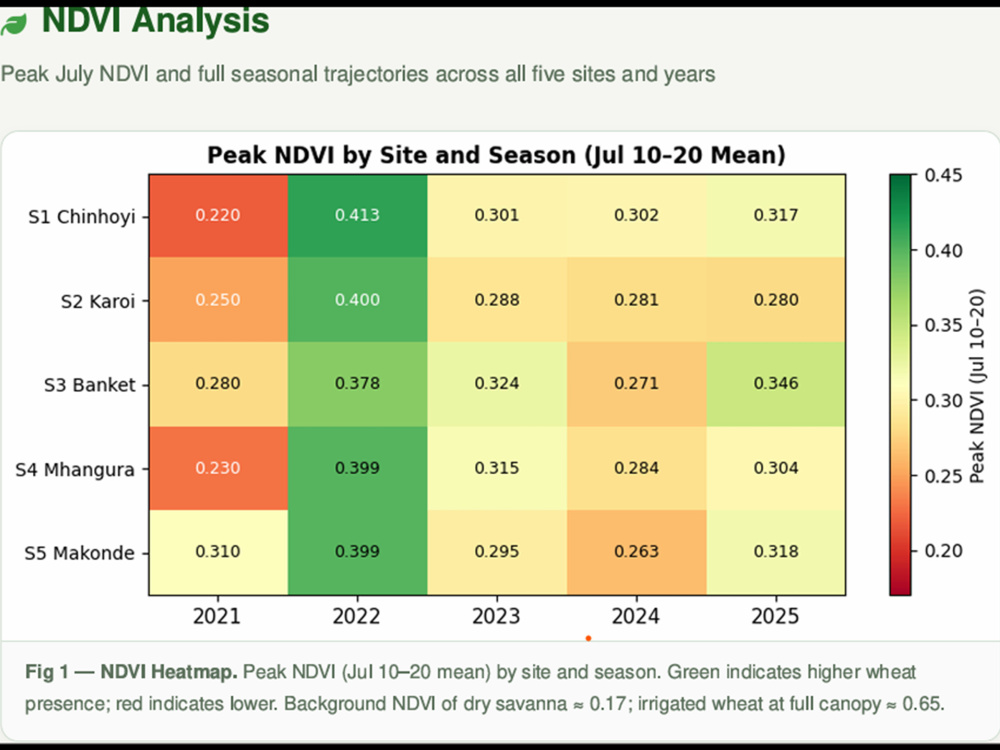
- Vegetation health monitoring using NDVI, LAI and EVI.
- Designing Location Intelligence strategies and integration for companies.
My interests is to work with companies/ clients that want to be management "compatible" and up-to date with emerging technologies in this information era, introduce them to the Geospatial analysis world. Land suitability/ site suitability analysis, Big data mining, analysis and management, Location Intelligence and GIS.
REMEMBER: Be part of the first 10 clients that get exceptional work at my current rate that is at a 50% discounted rate!
Steps for completing your project
After purchasing the project, send requirements so Isaxon can start the project.
Delivery time starts when Isaxon receives requirements from you.
Isaxon works on your project following the steps below.
Revisions may occur after the delivery date.
Discussion Meeting
Conduct a meeting to ensure all the client needs are taken into consideration. This is where I give suggestions on the best way to execute the project to attain the expected client needs and goals