You will get an amazing WebGIS Portal which can fulfill spatial needs
Top Rated

Project details
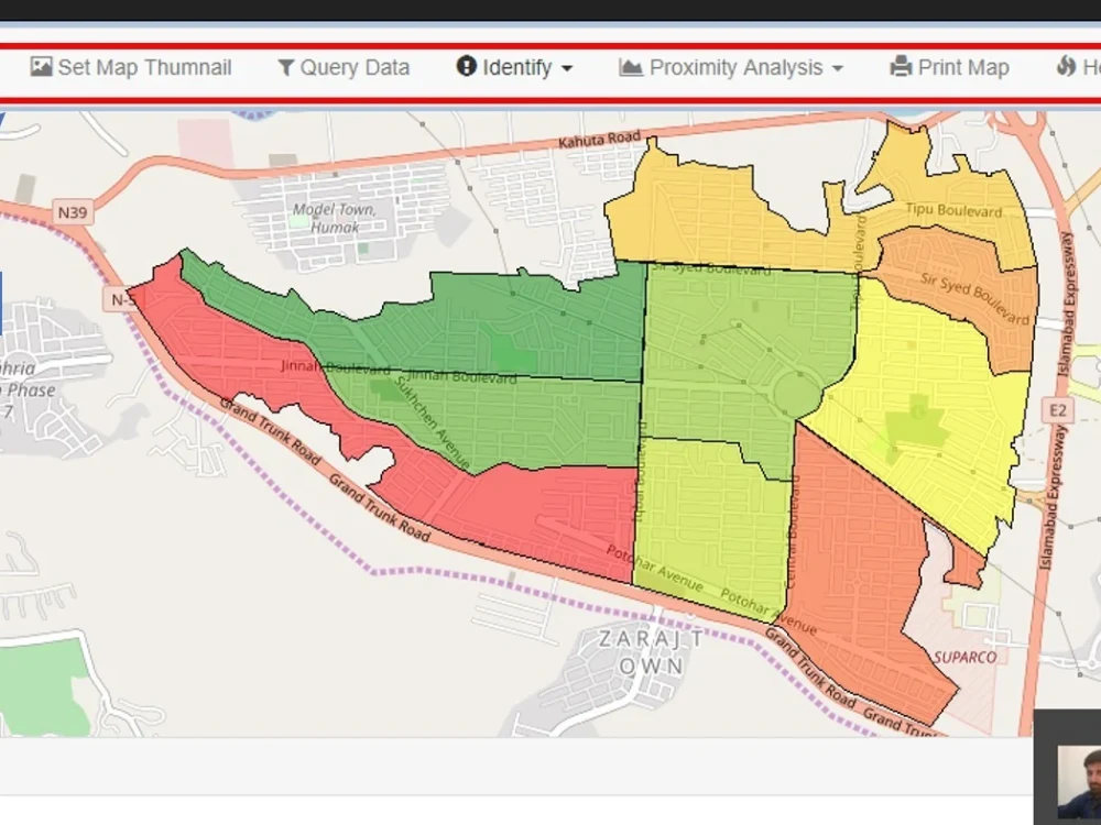
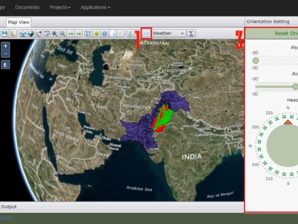
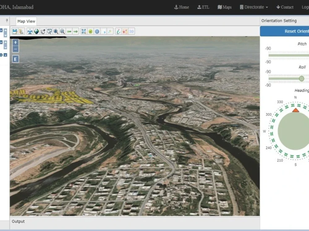
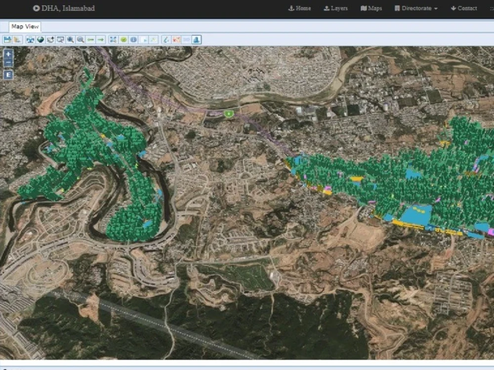
Web GIS provides many more opportunities to provide broader access to your authoritative GIS data, enabling you to move your system of record to a system of engagement that facilitates everything from self-service mapping to making better decisions. It makes GIS more accessible, more affordable, and more pervasive. It amplifies the value of GIS, and the role of GIS professionals.
Programming Languages
JavaScript, Python, C#What's included
| Service Tiers |
Starter
$300
|
Standard
$600
|
Advanced
$10,000
|
|---|---|---|---|
| Delivery Time | 20 days | 30 days | 70 days |
Number of Revisions | 1 | 2 | 5 |
Number of Pages | 2 | 3 | 5 |
Design Customization | - | - | |
Content Upload | |||
Responsive Design | |||
Source Code |
Frequently asked questions
27 reviews
(24)
(1)
(1)
(0)
(1)
This project doesn't have any reviews.
JZ
Jase Z.
Mar 13, 2026
Python Spatial Processing Engine
He seemed knowledgeable and was communicative.
FA
Feyijimi A.
Sep 19, 2025
Full Stack Developer with React and Geospatial Visualization Expertise
SY
Sagaf Y.
Jul 22, 2025
GIS Application Development with Python & Google Drive API
Working with Abdul on the GIS Application Development project was a great experience. He was highly professional, patient, and always receptive to feedback. His strong technical skills and collaborative attitude made a real difference in the success of the project. I truly appreciated his ability to find practical solutions and ensure smooth integration with the Google Drive API
JW
Jerel W.
Jun 2, 2025
Google Maps Developer for Real Estate Lead Visualization
Abdul was excellent to work with and very knowledgeable.
KR
Klaus R.
Jun 2, 2025
GeoSpatial Data Extraction and Transformation Auto
Excellent work on a complex geospatial data task. The freelancer demonstrated strong expertise in GIS and spatial data processing, delivering high-quality results on time. Communication was clear and proactive throughout. Would definitely recommend for any GIS-related projects and I will definitely come back for future projects.
About Abdul
Senior GIS Developer | WebGIS, PostGIS & Python
93%
Job Success
Lahore, Pakistan - 6:14 pm local time
I help businesses turn complex spatial data into reliable systems that are easier to manage, analyze, visualize, automate, and share with both technical and non-technical users.
I don’t just build maps or write GIS scripts. I focus on solving real business problems with geospatial technology — reducing manual GIS work, improving spatial data quality, speeding up spatial analysis, and turning scattered GIS files into structured tools, dashboards, APIs, and decision-ready applications.
🚀 Track record:
• 10+ years in GIS development and spatial software engineering
• $60K+ earned on Upwork
• 37 completed jobs
• 1,700+ Upwork hours
• Experience across WebGIS, cadastral systems, land records, mining, real estate, routing, dashboards, and GIS automation
✅ Selected outcomes:
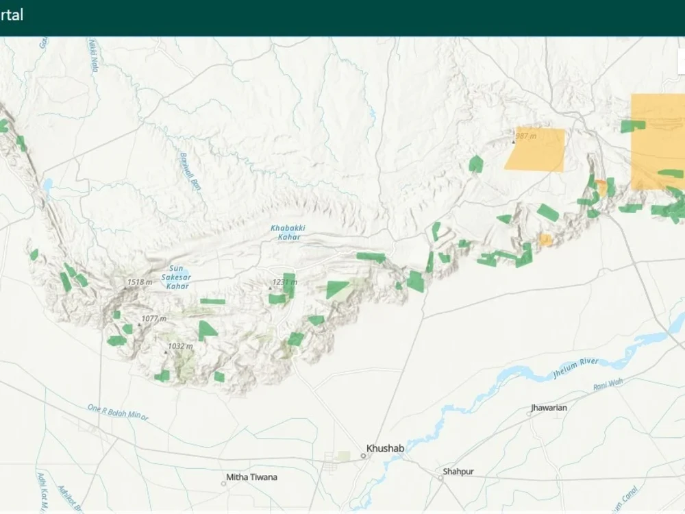
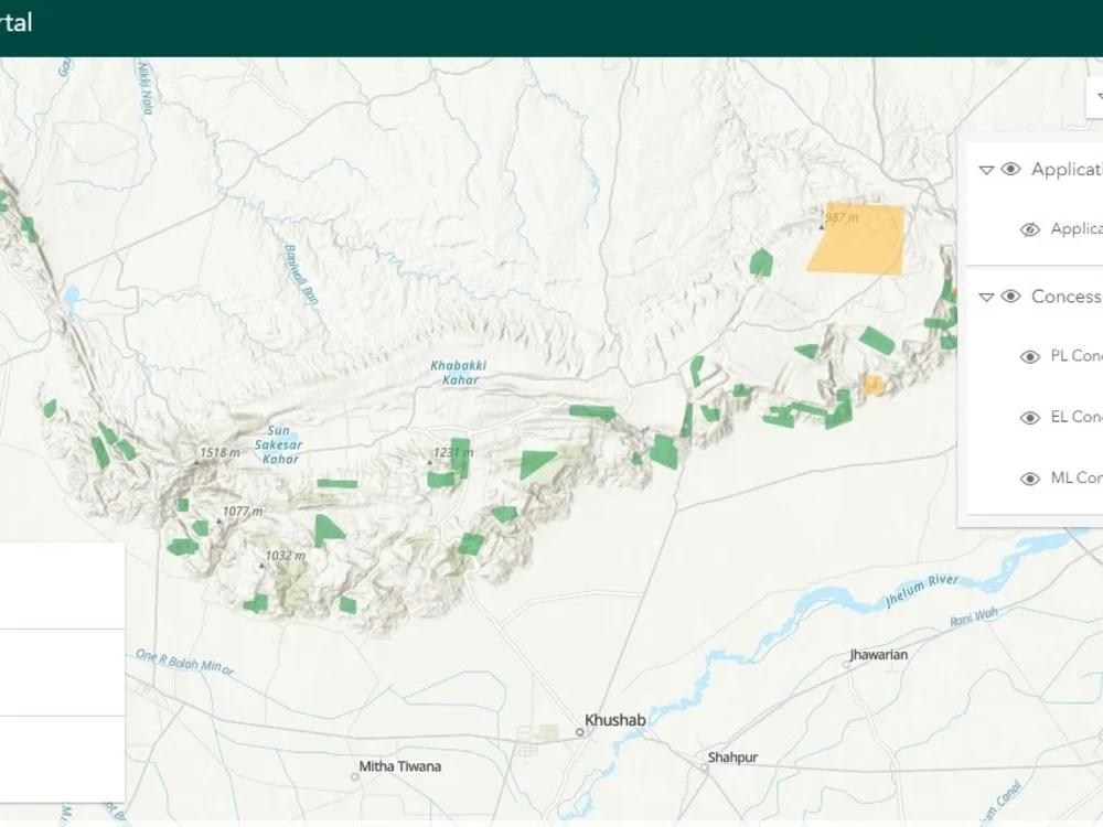
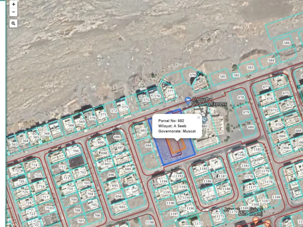
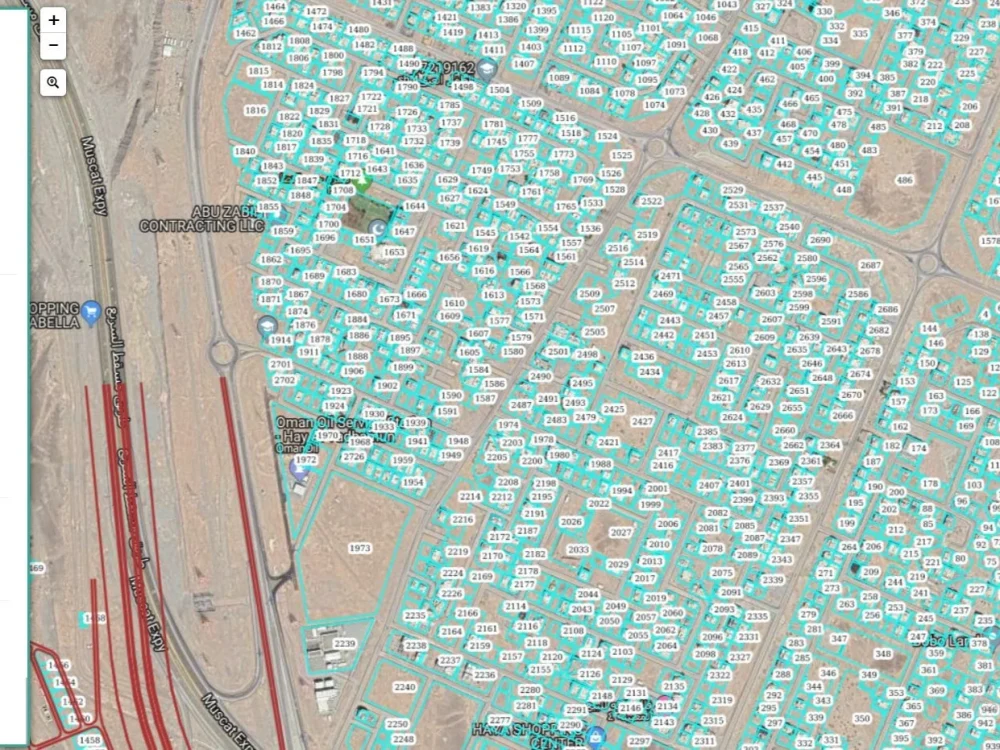
• Built a mining cadastral WebGIS portal used for concession management and spatial record workflows.
• Developed WebGIS dashboards that helped teams visualize land, parcel, and mining data in one system.
• Automated GIS processing workflows that reduced manual spatial data preparation and reporting effort.
• Built Mapryx, a browser-native GIS platform supporting 7+ spatial data formats, offline workflows, local/private processing, spatial SQL, and AI-assisted GIS analysis.
🗺️ What I can help you build:
• WebGIS platforms and interactive mapping applications
• Spatial REST APIs using GeoDjango, Django REST Framework, and PostGIS
• Map dashboards for monitoring, reporting, and decision-making
• PostGIS database design, spatial queries, and performance optimization
• QGIS plugins, ArcGIS Pro add-ins, ArcPy scripts, and PyQGIS automation
• Spatial data cleaning, conversion, validation, and processing pipelines
• Leaflet, Mapbox, MapLibre, OpenLayers, and ArcGIS JavaScript map interfaces
• Browser-based GIS tools using DuckDB-WASM, deck.gl, WebAssembly, and modern web mapping libraries
• Deployment on Linux, Docker, Nginx, Gunicorn, Azure, Google Cloud, and Cloudflare
🌐 Industries and workflows I understand:
• Land, parcel, cadastral, zoning, and property systems
• Mining cadastral portals and concession management
• Real estate and land visualization tools
• Routing, distance analysis, and location-based reporting
• Field data collection, inspection dashboards, and operational GIS
• Spatial data automation and large geodata processing
• Browser-native and offline GIS workflows
Most of my projects involve taking GIS work that is manual, scattered, slow, or difficult to use and turning it into a structured system with clean data, reliable APIs, interactive maps, automation, and practical tools for daily operations.
I also use modern AI-assisted development tools such as Codex, Claude Code, and AI agents to speed up development, improve code review, support documentation, and reduce repetitive work. The final solution is always reviewed, tested, and built around your project requirements.
My core stack includes Python, Django, GeoDjango, Django REST Framework, PostGIS, PostgreSQL, GeoServer, GDAL, ArcPy, PyQGIS, QGIS, ArcGIS Pro, Leaflet, Mapbox, MapLibre, OpenLayers, DuckDB-WASM, deck.gl, WebAssembly, Docker, Linux, Azure, Google Cloud, and Cloudflare.
My usual process is simple: understand your GIS problem, review your data and workflow, design the right architecture, build the solution step by step, test it with real use cases, and deliver a system your team can use confidently.
If you need a GIS developer who can understand the spatial problem, design the database, build the backend, create the map interface, automate workflows, and deploy the final system, I can help.
Steps for completing your project
After purchasing the project, send requirements so Abdul can start the project.
Delivery time starts when Abdul receives requirements from you.
Abdul works on your project following the steps below.
Revisions may occur after the delivery date.
Gather Requirements
Requirement Analysis for GIS work
Design
Web GIS layout and design