You will get ArcGIS Online Dashboards and Interactive StoryMaps
Project details
Transform Your Spatial Data into Actionable Business Intelligence!
Are you tired of looking at static maps and complex spreadsheets? I specialize in the Esri Ecosystem, helping businesses and organizations turn raw geospatial data into high-performance ArcGIS Online Dashboards and Interactive StoryMaps. Whether you are tracking assets, monitoring field operations, or presenting a project narrative to stakeholders, I build solutions that drive decisions.
What I offer in this Project:
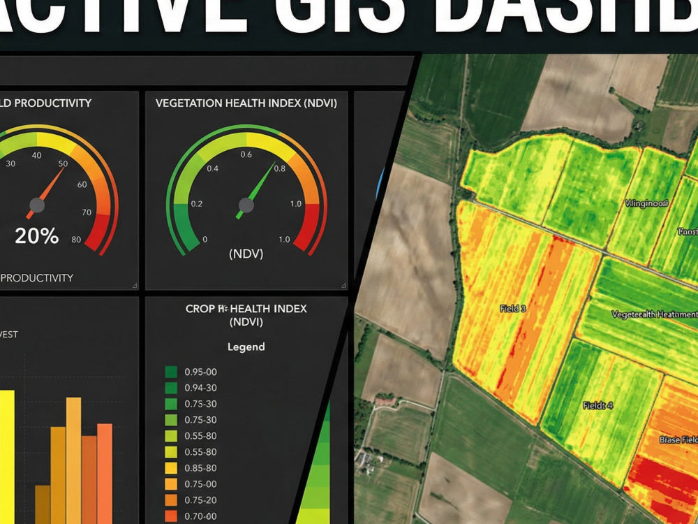
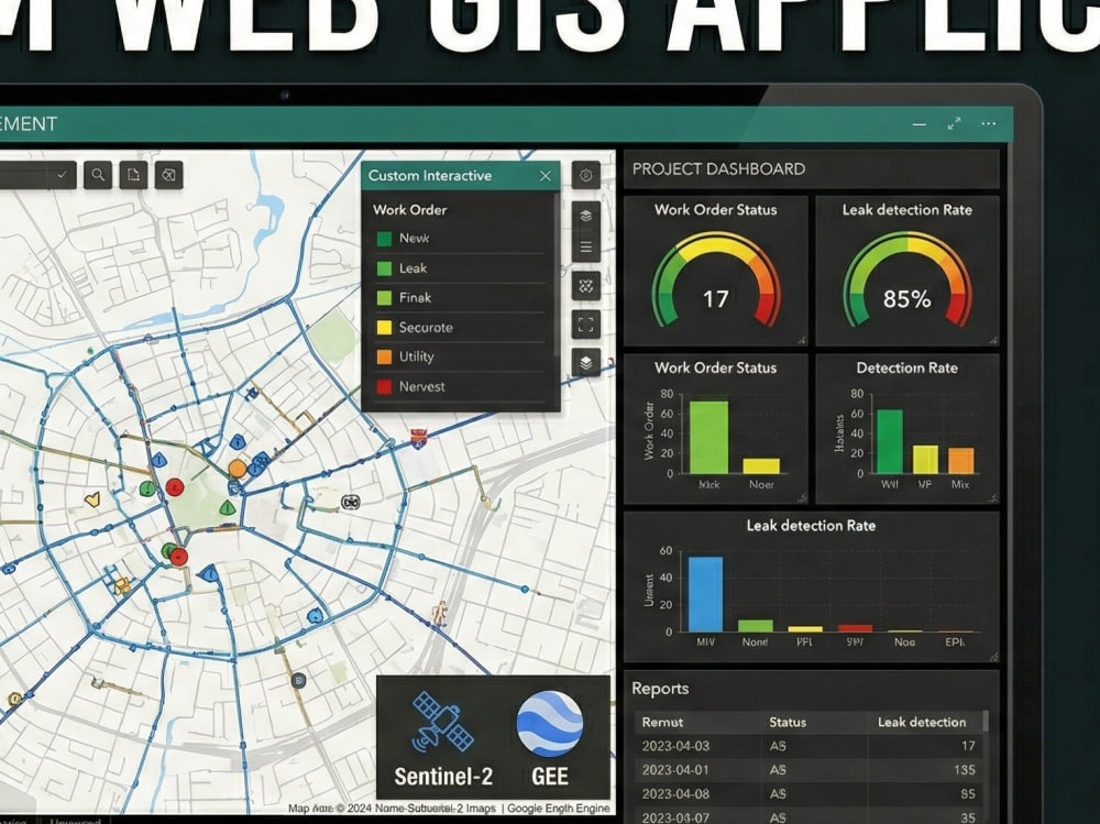
Interactive ArcGIS Dashboards: I design executive-level dashboards with real-time KPI dials, gauges, serial charts, and interactive spatial filters. Perfect for a "Single Source of Truth."
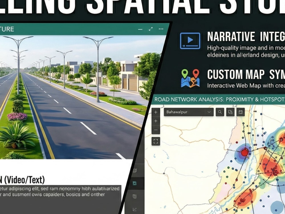
Compelling StoryMaps: I craft professional spatial narratives by integrating your maps with multimedia (images/videos) and scrolling text to tell a powerful story.
Data Integration & Automation: I can seamlessly connect your Google Sheets, Excel, or CSV files with ArcGIS Online layers for automated updates.
Custom Cartography: Beyond just points on a map, I ensure your data is styled professionally with custom symbology and branding.
Let’s put your data on the map. Order now or message me for a custom consultation
Are you tired of looking at static maps and complex spreadsheets? I specialize in the Esri Ecosystem, helping businesses and organizations turn raw geospatial data into high-performance ArcGIS Online Dashboards and Interactive StoryMaps. Whether you are tracking assets, monitoring field operations, or presenting a project narrative to stakeholders, I build solutions that drive decisions.
What I offer in this Project:
Interactive ArcGIS Dashboards: I design executive-level dashboards with real-time KPI dials, gauges, serial charts, and interactive spatial filters. Perfect for a "Single Source of Truth."
Compelling StoryMaps: I craft professional spatial narratives by integrating your maps with multimedia (images/videos) and scrolling text to tell a powerful story.
Data Integration & Automation: I can seamlessly connect your Google Sheets, Excel, or CSV files with ArcGIS Online layers for automated updates.
Custom Cartography: Beyond just points on a map, I ensure your data is styled professionally with custom symbology and branding.
Let’s put your data on the map. Order now or message me for a custom consultation
Data Tool
ArcGISWhat's included
| Service Tiers |
Starter
$50
|
Standard
$150
|
Advanced
$350
|
|---|---|---|---|
| Delivery Time | 3 days | 5 days | 7 days |
Number of Revisions | 1 | 2 | 3 |
Number of Graphs/Charts | 0 | 0 | 5 |
Number of Variations | 1 | 1 | 1 |
Data Source Connectivity | |||
Web Embedding | |||
Interactive/Animated Visuals |
2 reviews
(2)
(0)
(0)
(0)
(0)
This project doesn't have any reviews.
VS
Victoria S.
Feb 9, 2026
QGIS Projects Specialist Needed
Aurang was very helpful, super responsive and completed the work I needed on time. I recommend him for any QGIS mapping projects!
DD
Darren D.
May 8, 2023
Quick job for geography (GIS) problems
About Aurang
Spatial Data Scientist | GIS Developer | GEE Dashboards & Python
New Garden Town, Pakistan - 11:34 pm local time
Let’s be honest: In today’s market, location data geocoding and reverse geocoding is often the most underutilized asset in a company's toolkit. Whether you’re a Real Estate developer, a Commercial Farmer, or managing Logistics, ignoring spatial intelligence isn't just a missed opportunity. It’s a financial risk.
I don't just "make maps." I build Spatial Intelligence Systems.
With over 5 years of hands-on experience and a 100% Job Success Score, I help clients turn massive, messy datasets into clean, automated, and interactive dashboards that actually make sense for their bottom line. From calculating 21 sq km of glacier recession to building real-time crop phenology monitors for rice production, I’ve seen how the right spatial data can save millions.
✅ How I can help your business grow:
Risk Mitigation (Real Estate & Insurance): I don’t just show you a map; I analyze flood zones, terrain stability, and site suitability. I help you see the "red flags" before you commit capital.
Precision Agriculture (Ag-Tech):
I automate the boring stuff. Using Google Earth Engine (GEE), I build pipelines for NDVI and multispectral analysis so you can monitor crop health and yield without manual checking.
Operational Efficiency (Logistics & Utilities):
I optimize routes and manage assets (like FTTH or Power Plants) with sub-meter precision, cutting down fuel waste and operational lag.
Interactive Insights:
I transform decades of satellite archives into GEE Dashboards that your team can actually use to monitor changes in real-time.
🛡️ My Tech Arsenal (What I use to get results):
Cloud Power: Google Earth Engine (GEE) for large-scale time-series and LULC analysis.
Automation: Python (ArcPy, GeoPandas, Rasterio) My goal is always to turn a week’s worth of manual work into a 10-minute automated script.
Desktop GIS: ArcGIS Pro & QGIS (Expert level).
Specialized Sensing: LiDAR point cloud classification and RADAR (SAR) for flood and terrain monitoring.
Industries I’ve Empowered:
Real Estate | Precision Agriculture | NGOs & Sustainability | Urban Planning | Logistics & Safari Tourism | Mining & Energy.
I’ve delivered $12,000+ worth of complex projects by focusing on one thing: Accuracy. If your data isn't precise, it’s useless.
"If you haven't audited your spatial data yet, you're likely operating in the dark. Let’s have a quick chat and turn your location data into your biggest competitive advantage."
Steps for completing your project
After purchasing the project, send requirements so Aurang can start the project.
Delivery time starts when Aurang receives requirements from you.
Aurang works on your project following the steps below.
Revisions may occur after the delivery date.
Data Assessment & Setup
I will review your provided datasets (Excel, Shapefiles, etc.) and ensure your ArcGIS Online organizational account is ready for hosting the project
Core Map & Analysis Design
Creating the central web map with custom symbology, pop-ups, and spatial layers. I will perform any necessary spatial analysis required for the final output