Hasem isn't taking new orders for this project right now. Here are some similar projects to explore.
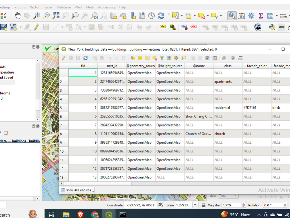
You will get building footprint data collection and analysis with postgresql database.
Project details
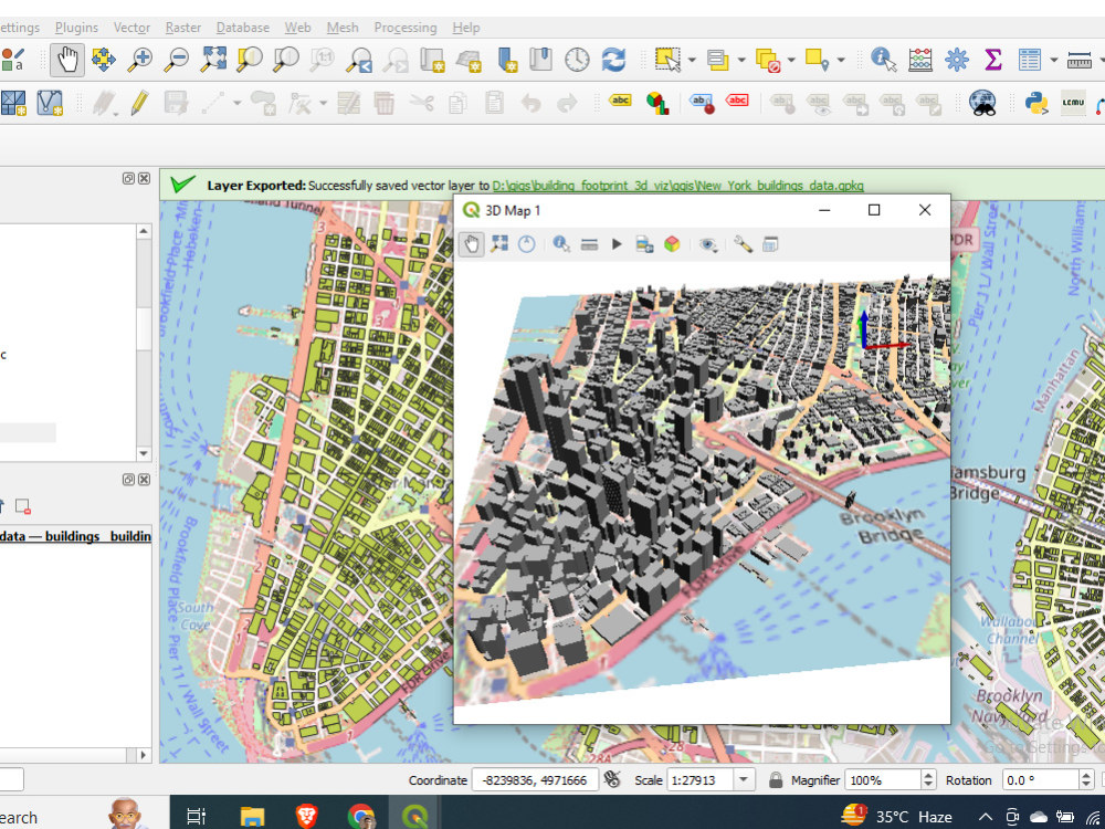
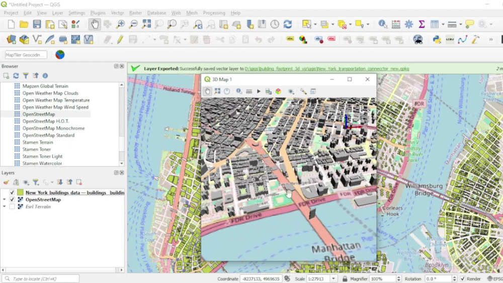
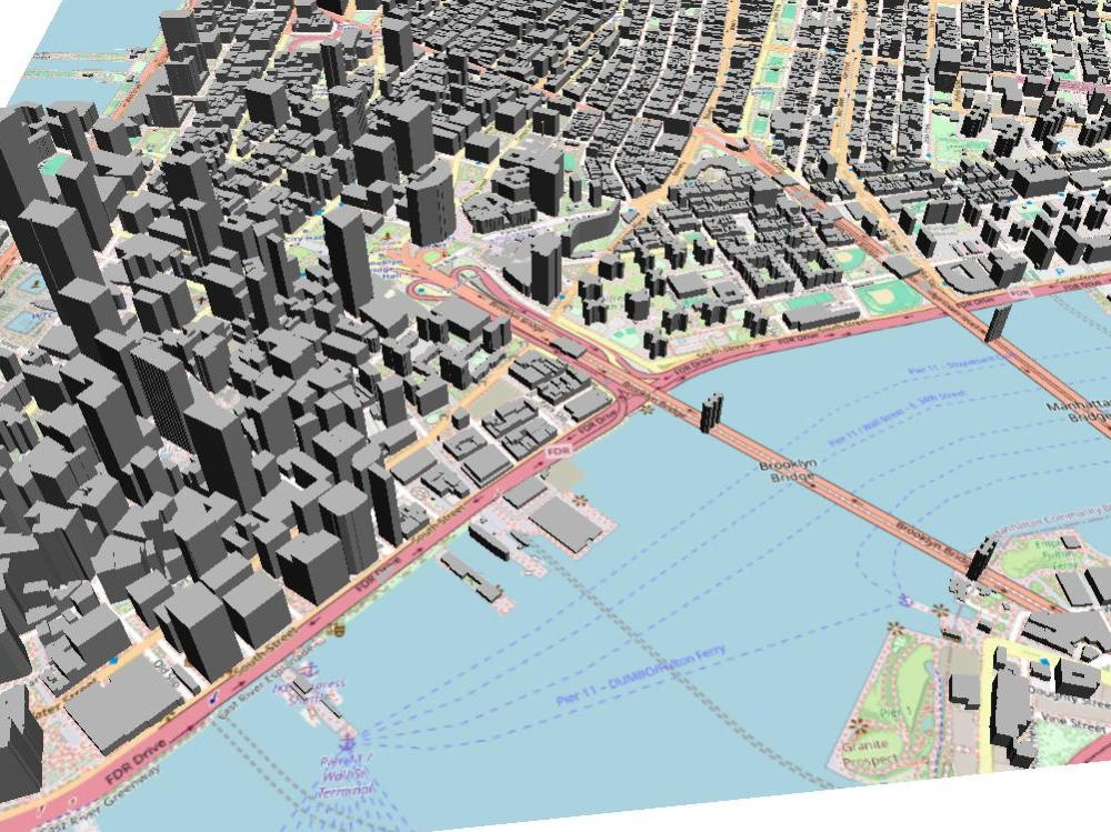
My project specializes in providing precise building footprint extraction and stunning 3D visualizations using the power of QGIS and Python. Leveraging cutting-edge geospatial technology, I ensure highly accurate spatial data analysis, whether for urban planning, architecture, or real estate development.
What sets my service apart is the combination of automated Python scripting and the advanced visualization capabilities of QGIS, enabling efficient workflows and detailed, interactive 3D models. With a deep understanding of geospatial analysis and experience in handling diverse datasets, I offer tailored solutions that transform raw data into visually compelling, easy-to-understand 3D models.
Whether you need footprints extracted from satellite imagery, LIDAR data, or other sources, my approach ensures a smooth integration into your projects while enhancing the spatial understanding of the landscape.
Database Type
PostgreSQLWhat's included
| Service Tiers |
Starter
$75
|
Standard
$125
|
Advanced
$200
|
|---|---|---|---|
| Delivery Time | 1 day | 2 days | 3 days |
Number of Revisions | 1 | 2 | 4 |
Number of Queries | 5 | 10 | 15 |
Query Debugging | |||
Query Optimization | |||
Query Scheduling | - | - | - |
Query Analysis | - | ||
Source Code | - | - |
Optional add-ons
You can add these on the next page.
Additional Revision
+$25
Additional Query
+$15
Source Code
+$75About Hasem
Geospatial Data Scientist || Full Stack GIS Developer
Kolkata, India - 12:55 am local time
With over 6 years of hands-on experience, I specialize in delivering innovative GIS solutions for complex projects. My expertise spans across GIS analysis, WebGIS development, and Geospatial Data Science, consistently driving results and exceeding expectations.
I have a strong foundation in Python, JavaScript, and SQL, using these technologies to create efficient, scalable geospatial solutions. For front-end development, I use JavaScript and Vue.js or React.js to create seamless, user-friendly interfaces. My database expertise includes PostgreSQL/PostGIS for spatial data management, and I'm also proficient with DuckDB for additional data processing needs.
If you're looking for cutting-edge GIS solutions tailored to your project’s unique needs, I’m here to help you achieve success.
**Services**
1. GIS Analysis
-- Georeferencing and Digitization
-- Geoprocessing & Spatial Modelling
-- Cartography & Map production
-- Data Cleaning, Visualization & Interactive Mapping
-- Custom GIS Application Development
-- GIS Data Conversion
2. Remote Sensing
-- Automatic Satellite Image Collection
-- MOSIC, CLIP, False Color Composite, True Color Composite, etc..
-- Band Rationing (NDVI, NDWI, EVI, etc..) or Indices Calculation & Automation
-- Microwave Remote Sensing Services (ex - preprocessing, flood inundation mapping etc.).
-- DEM, Terrain Analysis & Hydrology Analysis.
-- Lidar Data Analysis Services
3. GeoAI
-- Machine Learning Models for Geospatial Analysis
-- Image Classification & Object Detection using ML and AI
-- Feature Extraction from Satellite Images
-- Supervised Classification
-- Unsupervised Classification
4. Spatial Database Management
-- Spatial Database Design & Implementation
-- Data Modelling & Schema Development
-- Spatial Quarry & Non-Spatial Quarry
-- Performance Optimization & Spatial Indexing
5. .WebGIS
-- Web-based GIS applications using JavaScript and JS Framework.
-- Custom Web-GIS application based on objectives.
-- Map services integration (WMS, WTS etc..)
I look forward to connecting with you on your GIS projects. Feel free to reach out to me anytime!
Steps for completing your project
After purchasing the project, send requirements so Hasem can start the project.
Delivery time starts when Hasem receives requirements from you.
Hasem works on your project following the steps below.
Revisions may occur after the delivery date.
Project overview, objectives and data collection
Data processing and analysis