You will get Drone Mapping & Photogrammetry for Accurate Land Surveys (Agisoft, Pix4D)
Project details
Do you need high-precision drone mapping and 3D photogrammetry for land surveys, construction, agriculture, or environmental monitoring?
I offer professional drone data processing services using industry-standard tools like Agisoft Metashape and Pix4D to deliver accurate orthomosaics, DSM/DTMs, contour maps, and 3D models—tailored to your needs.
With 6+ years of experience in GIS & Remote Sensing, I ensure your spatial data is processed, visualized, and delivered with top-tier accuracy and efficiency.
What This Gig Offers:
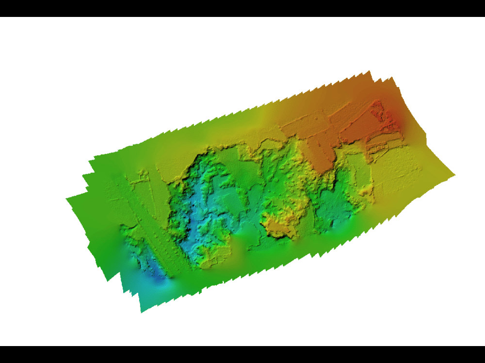
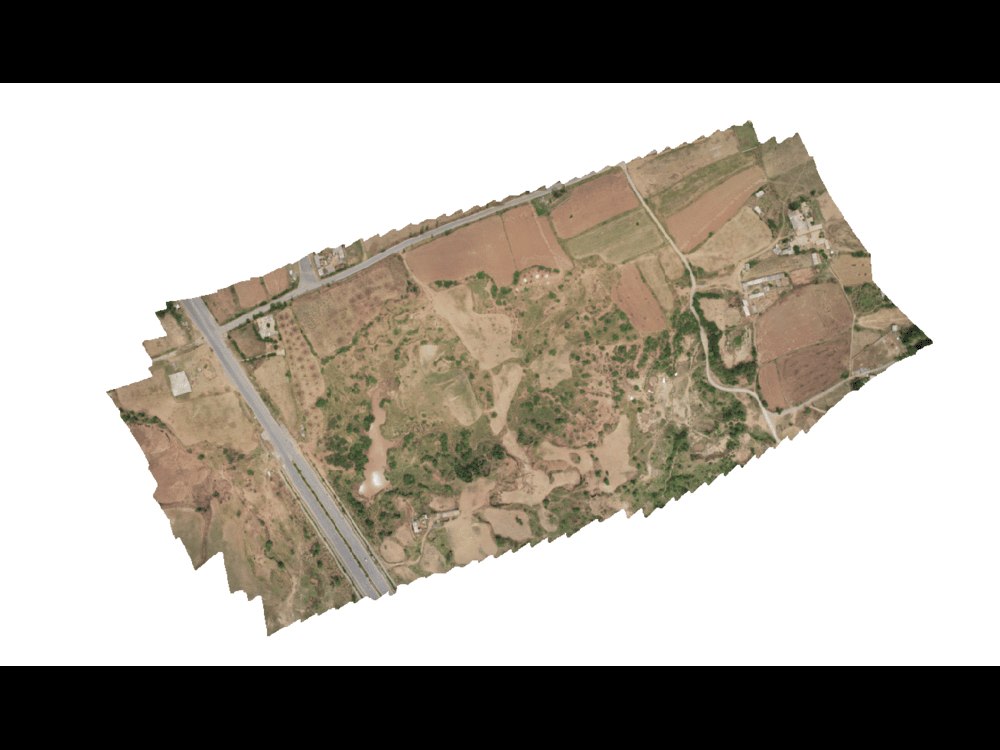
✅ Orthomosaic Map Generation (GeoTIFF, high-resolution, georeferenced)
✅ Digital Surface Models (DSM) & Digital Terrain Models (DTM)
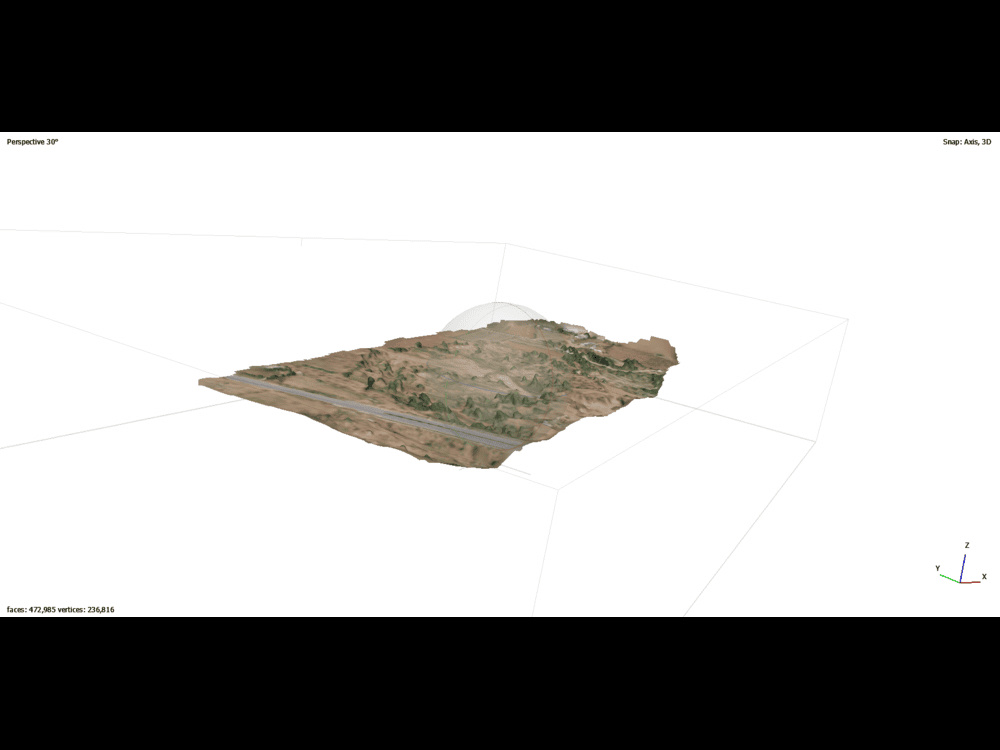
✅ 3D Point Clouds & Mesh Models
✅ Contour Mapping for Elevation Analysis
✅ Volume Calculations (stockpiles, excavation, earthworks)
✅ Georeferencing & Coordinate System Alignment
✅ File Outputs in SHP, KML, GeoTIFF, LAS, DXF, etc.
✅ Ready-to-use data for ArcGIS, AutoCAD, QGIS, and more
📦 Deliverables:
High-resolution orthomosaic imagery
DSM/DTM raster layers
3D point cloud files (.las/.laz)
Contour shapefiles (custom interval)
Project report (optional)
File formats compatible with ArcGIS, QGIS, AutoCAD, Civil 3D
I offer professional drone data processing services using industry-standard tools like Agisoft Metashape and Pix4D to deliver accurate orthomosaics, DSM/DTMs, contour maps, and 3D models—tailored to your needs.
With 6+ years of experience in GIS & Remote Sensing, I ensure your spatial data is processed, visualized, and delivered with top-tier accuracy and efficiency.
What This Gig Offers:
✅ Orthomosaic Map Generation (GeoTIFF, high-resolution, georeferenced)
✅ Digital Surface Models (DSM) & Digital Terrain Models (DTM)
✅ 3D Point Clouds & Mesh Models
✅ Contour Mapping for Elevation Analysis
✅ Volume Calculations (stockpiles, excavation, earthworks)
✅ Georeferencing & Coordinate System Alignment
✅ File Outputs in SHP, KML, GeoTIFF, LAS, DXF, etc.
✅ Ready-to-use data for ArcGIS, AutoCAD, QGIS, and more
📦 Deliverables:
High-resolution orthomosaic imagery
DSM/DTM raster layers
3D point cloud files (.las/.laz)
Contour shapefiles (custom interval)
Project report (optional)
File formats compatible with ArcGIS, QGIS, AutoCAD, Civil 3D
What's included
| Service Tiers |
Starter
$20
|
Standard
$40
|
Advanced
$60
|
|---|---|---|---|
| Delivery Time | 2 days | 3 days | 6 days |
Number of Revisions | 2 | 2 | 2 |
Number of Pages Mined/Scraped | 2 | 4 | 10 |
Number of Sources Mined/Scraped | 3 | 5 | 5 |
2 reviews
(2)
(0)
(0)
(0)
(0)
This project doesn't have any reviews.
FM
Faiz M.
Sep 18, 2025
ArcGIS Pro Specialist Needed for Mapping and Data Analysis
RM
Ruapu M.
May 27, 2024
GIS Analyst/Researcher
Adbul absolutely overdelivered with his work. The task I set was quite long and the structure I required was vague, but Abdul took it upon himself to structure it in a concise output that I can share with my staff. I recommend his services.
About Abdul
GIS | Remote Sensing | WebGIS | Cartography| MHVRA | HEC-RAS | PowerBI
50%
Job Success
Chitral, Pakistan - 1:42 am local time
I help businesses, researchers, planners, and government organizations extract actionable insights from spatial data using the latest GIS and remote sensing tools like ArcGIS, QGIS, ENVI, ERDAS Imagine, SNAP, and drone mapping software.
With over 4 years of experience, I specialize in:
Georeferencing and Digitization
Land use/land cover classification
Disaster risk assessment (GLOFs, floods, landslides)
Urban planning & infrastructure mapping
Drone imagery analysis & photogrammetry
Hydrological and environmental modeling
Remote sensing for agriculture & forestry
Geospatial data processing using ArcGIS, QGIS, ENVI, ERDAS Imagine, SNAP
Data Visualization using GIS and transferring it into Power BI for Insights
🛰️ Whether you need satellite data processing, drone image analysis, or custom GIS dashboards, I deliver high-quality maps and reports to support urban planning, environmental conservation, climate research, and more.
🏆 Why Choose Me?
✅ 100% accurate and detailed GIS deliverables
✅ Clear communication and timely delivery
✅ Custom solutions tailored to your project needs
✅ High-resolution outputs ready for reports, publications, or decision-making
Steps for completing your project
After purchasing the project, send requirements so Abdul can start the project.
Delivery time starts when Abdul receives requirements from you.
Abdul works on your project following the steps below.
Revisions may occur after the delivery date.
step.1
Discuss your project details. after that let everything on me
step 2
data will collect as per your requirement.