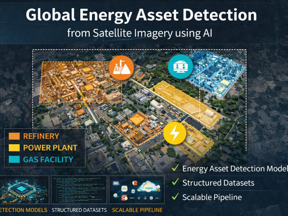
You will get energy asset detection from satellite imagery using AI
Top Rated
Project details
🚀 I build AI systems that detect and structure energy infrastructure from satellite imagery at scale.
If you have satellite data and need to identify assets like refineries, power plants, or gas facilities, I can help you turn raw imagery into structured, analysis-ready intelligence.
💡 What this gig covers
I will build a system that:
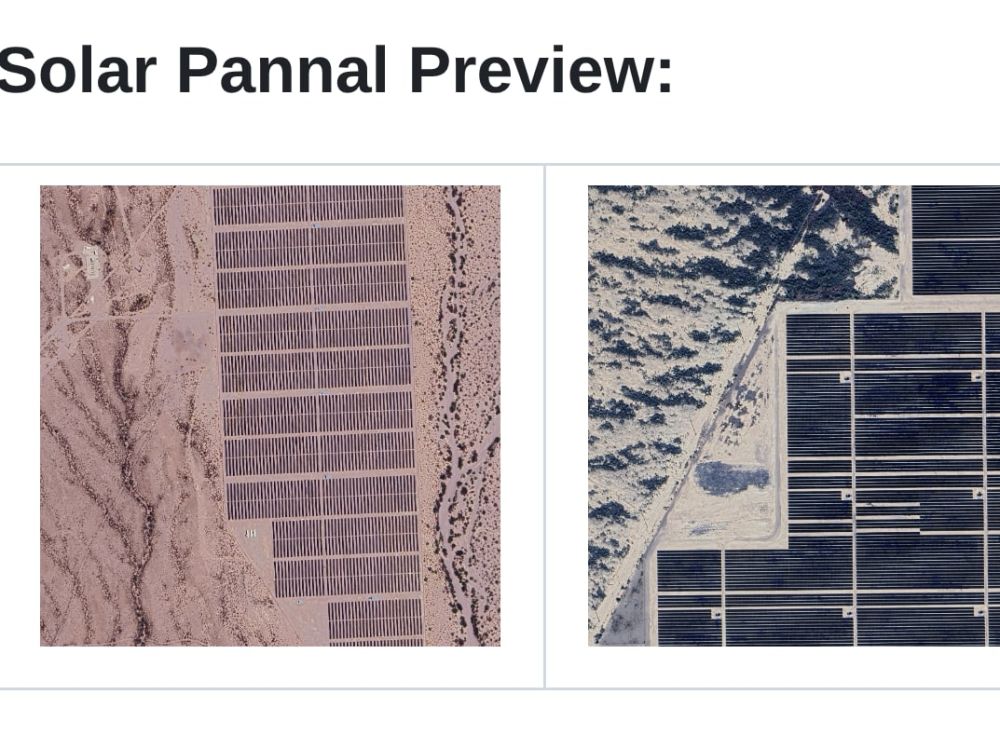
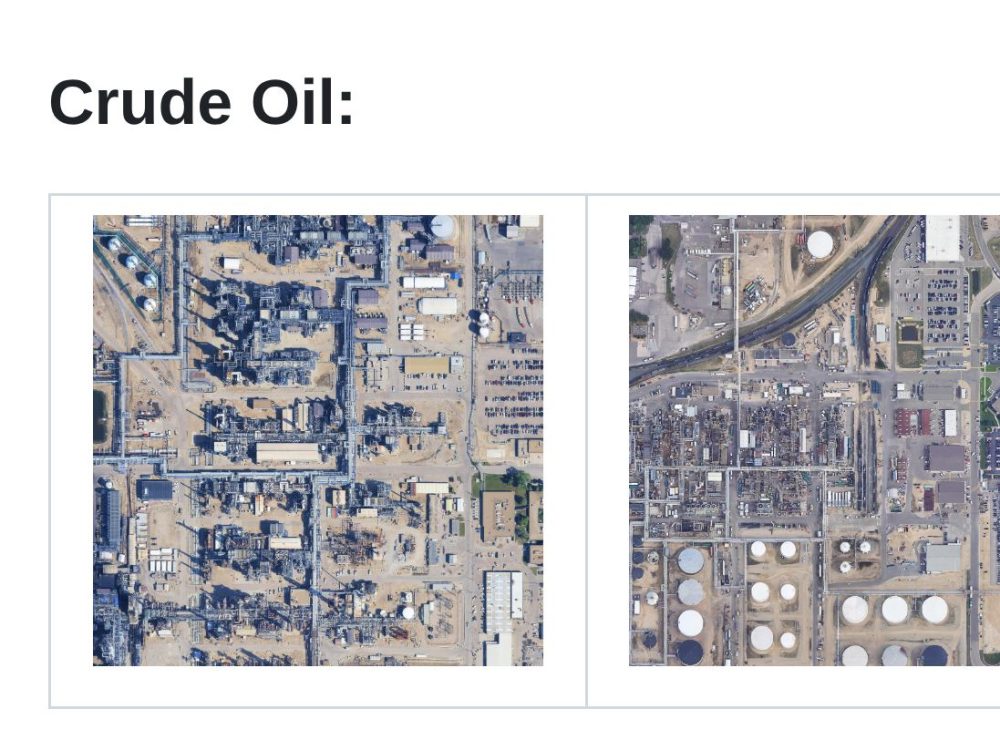
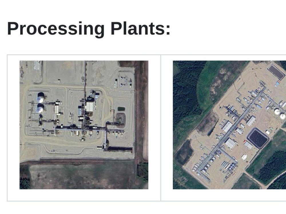
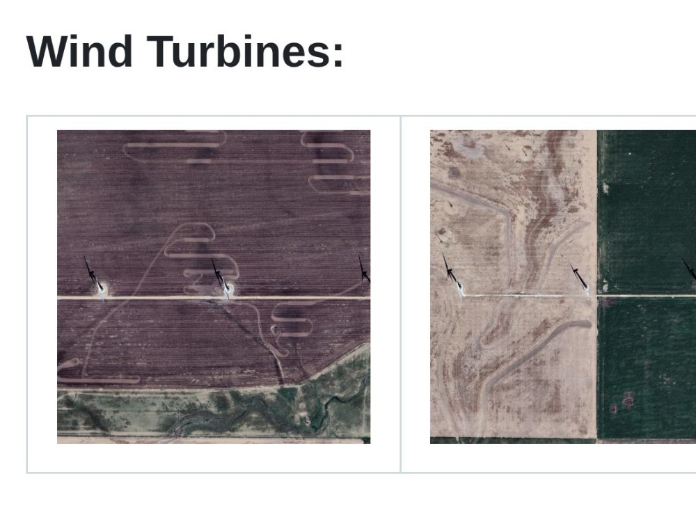
✔ Detects energy assets (refineries, power plants, gas facilities, rigs)
✔ Processes large satellite datasets (Sentinel, Landsat, Planet, Maxar)
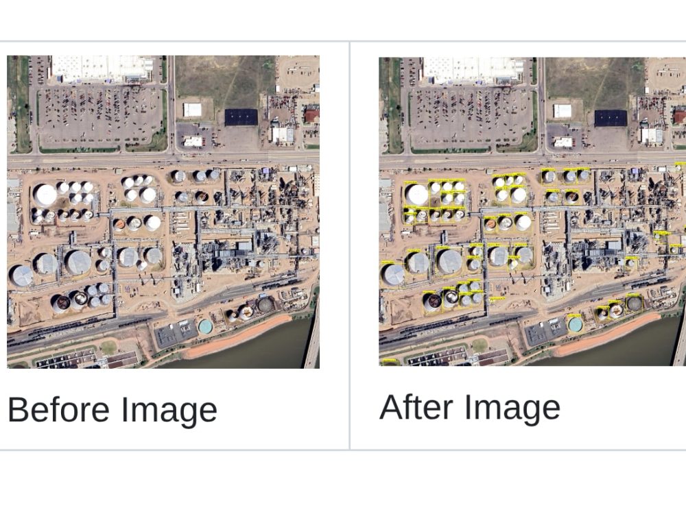
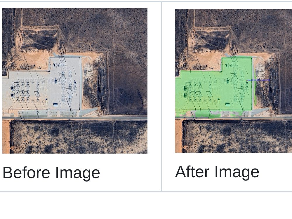
✔ Converts imagery into structured datasets for analytics
✔ Eliminates manual analysis workflows
This is ideal for:
⚡ Energy analytics platforms
🏦 Financial / investment firms
📊 Data companies building intelligence products
🌍 Market and infrastructure monitoring
🧱 What you get
✔ Multi-class detection models for energy infrastructure
✔ End-to-end processing pipeline (ingestion → inference → output)
✔ Structured datasets (GeoJSON, shapefiles, etc.)
✔ Scalable system ready for large datasets
⚙️ Tech & approach
✔ Computer Vision (object detection, segmentation)
✔ Satellite imagery processing
✔ Geospatial pipelines (GDAL, Rasterio)
✔ Scalable data processing workflows
If you have satellite data and need to identify assets like refineries, power plants, or gas facilities, I can help you turn raw imagery into structured, analysis-ready intelligence.
💡 What this gig covers
I will build a system that:
✔ Detects energy assets (refineries, power plants, gas facilities, rigs)
✔ Processes large satellite datasets (Sentinel, Landsat, Planet, Maxar)
✔ Converts imagery into structured datasets for analytics
✔ Eliminates manual analysis workflows
This is ideal for:
⚡ Energy analytics platforms
🏦 Financial / investment firms
📊 Data companies building intelligence products
🌍 Market and infrastructure monitoring
🧱 What you get
✔ Multi-class detection models for energy infrastructure
✔ End-to-end processing pipeline (ingestion → inference → output)
✔ Structured datasets (GeoJSON, shapefiles, etc.)
✔ Scalable system ready for large datasets
⚙️ Tech & approach
✔ Computer Vision (object detection, segmentation)
✔ Satellite imagery processing
✔ Geospatial pipelines (GDAL, Rasterio)
✔ Scalable data processing workflows
Machine Learning Tools
BigDL, ChatGPT, MLflow, pandas, PyTorch, SciPy, SQLWhat's included
| Service Tiers |
Starter
$1,800
|
Standard
$4,500
|
Advanced
$8,000
|
|---|---|---|---|
| Delivery Time | 15 days | 25 days | 35 days |
Number of Revisions | Unlimited | Unlimited | Unlimited |
Number of Model Variations | 1 | 3 | 7 |
Number of Scenarios | 5 | 5 | 5 |
Model Validation/Testing | - | - | - |
Model Documentation | - | - | - |
Data Source Connectivity | - | - | - |
Source Code | - | - | - |
10 reviews
(8)
(2)
(0)
(0)
(0)
This project doesn't have any reviews.
KM
Kyle M.
Oct 30, 2025
Custom call recording service
SA
Suhaib A.
Sep 3, 2025
OX-04 Robotic Manipulation Software Design & Implementation
Slah is a one of a kind robotics software coding professional who has all what it takes to deliver a robust functioning product Highly recommended for any high-end robotics programming job.
EG
Evan G.
Mar 10, 2025
AI Object Detection Specialist for Satellite Imagery (YOLO)
Pleasure to work with!
JW
Jonathan W.
Jan 14, 2025
Onshape Step file to URDF
SLAH Is really notes his way around and URDF files. What I thought was a simple project turned out to be very complex and he was able to create a custom of URDF file for me. He is a pleasure to work with- And he always gives 110%
MB
Manu B.
Jun 15, 2024
Onnx Conversation to Tflite model
Slahuddin was a great asset to our project. His expertise in converting models from ONNX to TFLite was impressive, and he delivered high-quality work consistently.
About SLAH
AI Engineer for Visual & Geospatial Intelligence | CV, LLMs, Edge AI
100%
Job Success
Lahore, Pakistan - 1:08 am local time
💵 $40-60/hr
🚀 I build AI systems that turn visual & complex data into real intelligence, not demos.
If you have satellite imagery, video, sensor data, or large datasets but struggle to extract insights, automate workflows, or build production-ready AI…
👉 I help you turn that into a scalable, usable system.
---
🎯 What I do
I help companies transform raw data into:
✔ Detectable objects (assets, infrastructure, events)
✔ Structured, usable datasets
✔ Queryable intelligence (APIs, dashboards, AI agents)
Most of my work sits at the intersection of:
🛰️ Satellite & geospatial data
📹 Video / camera / drone imagery
🤖 AI agents & intelligent query systems
---
💡 Common problems I solve
✔ “We have image/satellite data but no usable insights”
✔ “We need to detect and track objects at scale”
✔ “Our analysts are doing manual work that should be automated”
✔ “We want to query our data using AI”
✔ “We need real-time or edge AI (cameras, drones, devices)”
---
🧱 What I build (systems, not scripts)
★ Object detection pipelines (satellite, CCTV, drone)
★ Change detection & monitoring systems
★ Data pipelines (ingestion → processing → structured output)
★ AI query layers (chatbots, APIs, agent workflows)
★ Edge + cloud deployments
👉 Same core system, adapted to your use case
---
🛰️ Experience
Geospatial & infrastructure intelligence
✔ Roads, pipelines, power plants, industrial assets
✔ Satellite imagery (Sentinel, Landsat, Planet, Maxar)
✔ Large-scale mapping & change detection
Visual intelligence (camera / drone / CCTV)
✔ Object detection, tracking, segmentation
✔ Real-time monitoring systems
✔ Industrial, security & operational use cases
AI agents & data interaction
✔ Natural language interfaces over complex datasets
✔ RAG systems + tool-using agents
✔ Workflow automation (filtering, querying, analysis)
---
📈 Results I’ve delivered
⚡ Reduced manual analysis by 80–90%
🛰️ Built satellite detection systems used in commercial products
🛩️ Real-time vision systems under 100ms latency
🤖 AI agents replacing analyst workflows
💸 Reduced AI compute costs by 50%+
---
🔧 How I work
✔ Define success metrics (latency, accuracy, cost)
✔ Design clear system architecture
✔ Build fast, iterate early — no black boxes
✔ Deliver production-ready systems with monitoring
---
🎯 Best fit clients
✔ Companies with large datasets (images, satellite, video, sensor, text)
✔ Teams building data or analytics products
✔ Startups turning data into a commercial offering
✔ Businesses that need production-ready AI
❌ Not a fit for small scripts or generic chatbot work
---
📩 Ready to start?
Send me:
✔ What data you have
✔ What you want to detect / analyze
✔ Where this system will run (cloud / edge / etc.)
I’ll respond with a clear plan and next steps.
---
🔎 Core tech
Computer Vision • Satellite AI • Geospatial ML • YOLO • SAM • PyTorch
RAG • LangGraph • AI Agents • vLLM
Edge AI • TensorRT
AWS • GCP • Docker • Ray • MLflow
Steps for completing your project
After purchasing the project, send requirements so SLAH can start the project.
Delivery time starts when SLAH receives requirements from you.
SLAH works on your project following the steps below.
Revisions may occur after the delivery date.
Requirement Review & Data Assessment
Understand dataset, asset types, and project scope.
Solution Design & Setup
Design detection models and data pipeline.