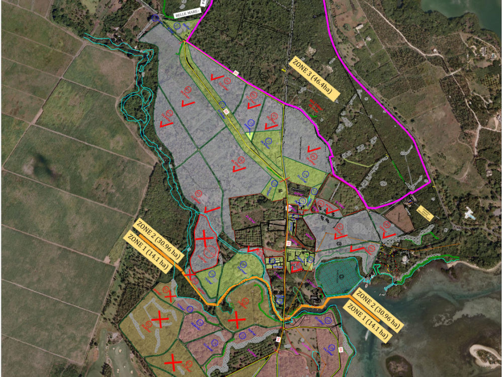
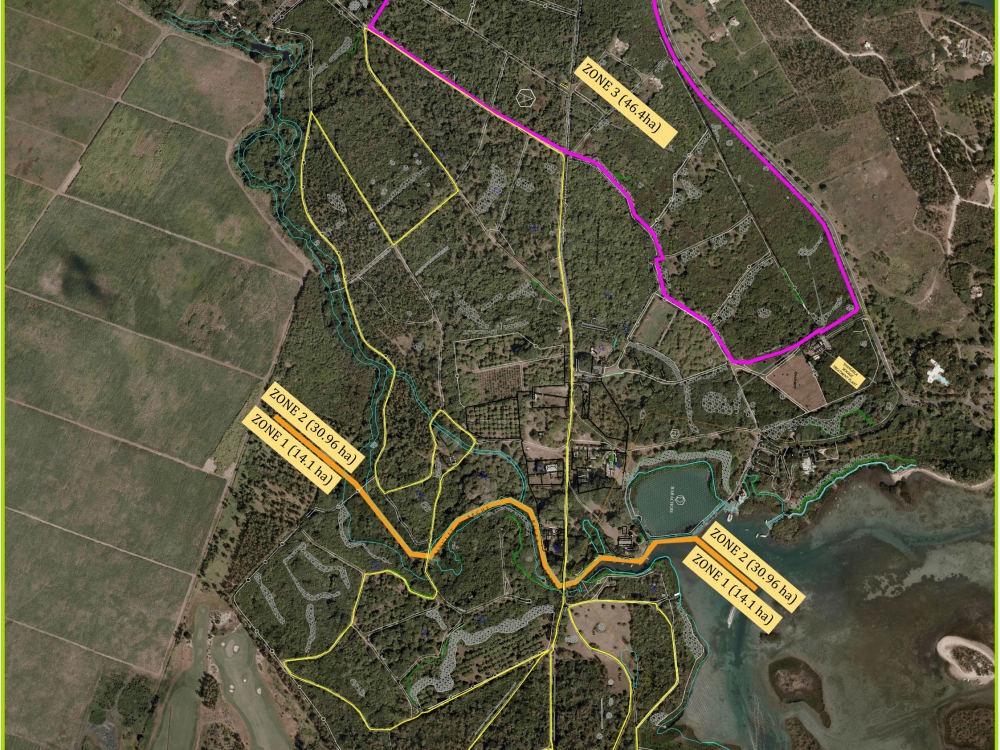
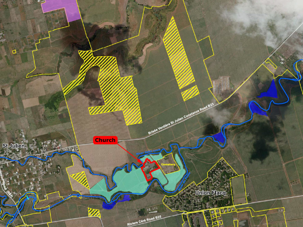
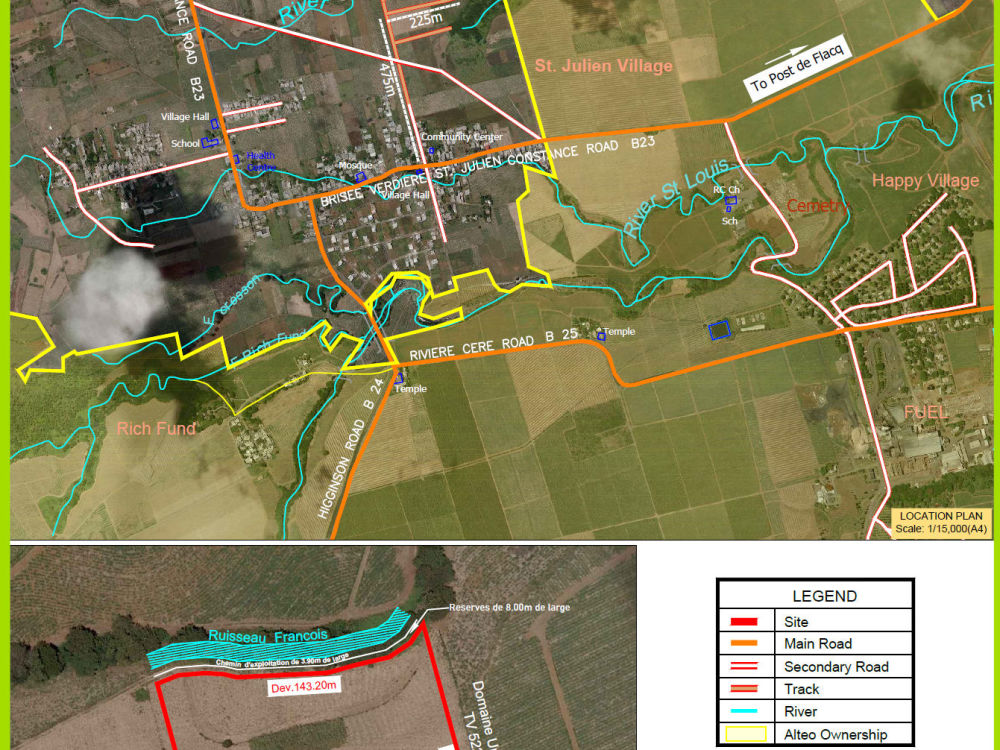
You will get get a professional site plan map created in ArcGIS/QGIS
Top Rated
Top Rated
Project details
What sets my work apart is the combination of technical GIS accuracy, cartographic skill, and design versatility I bring to every site plan. With more than a decade of experience in geospatial analysis, environmental mapping, and development-focused cartography, I create site maps that are not only precise and properly georeferenced, but also visually clear, presentation-ready, and tailored to each client’s goals.
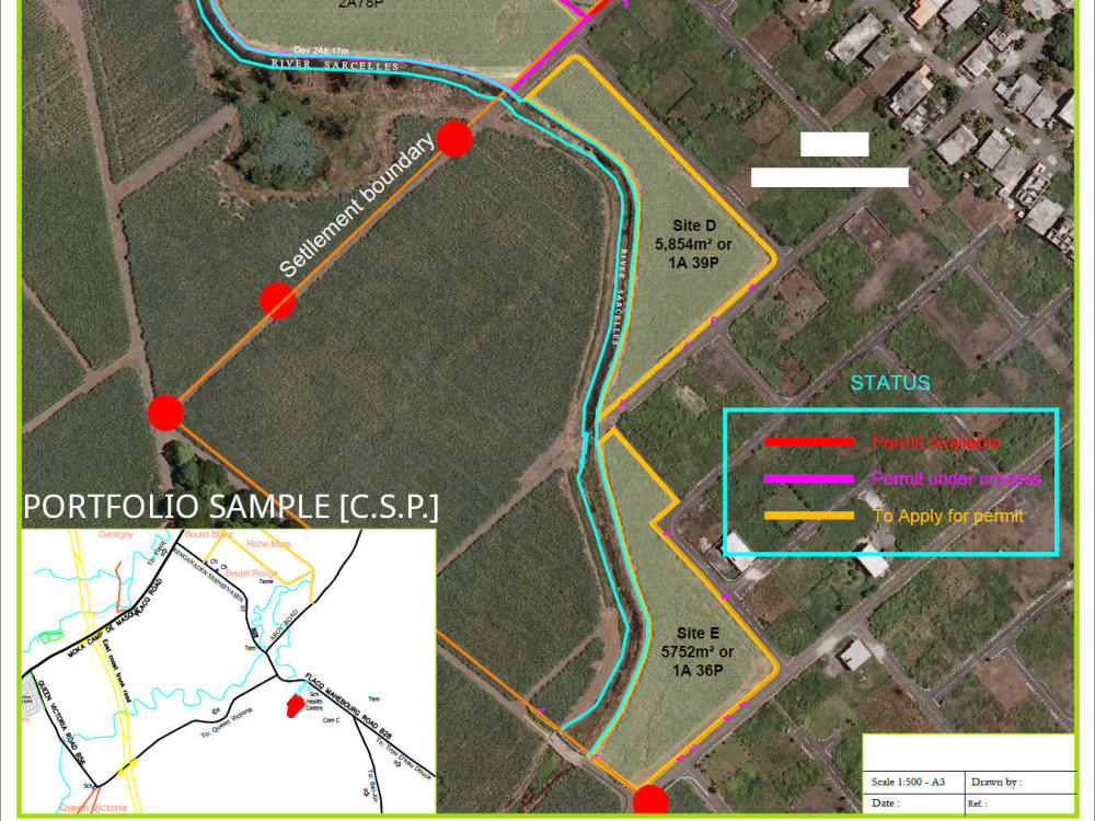
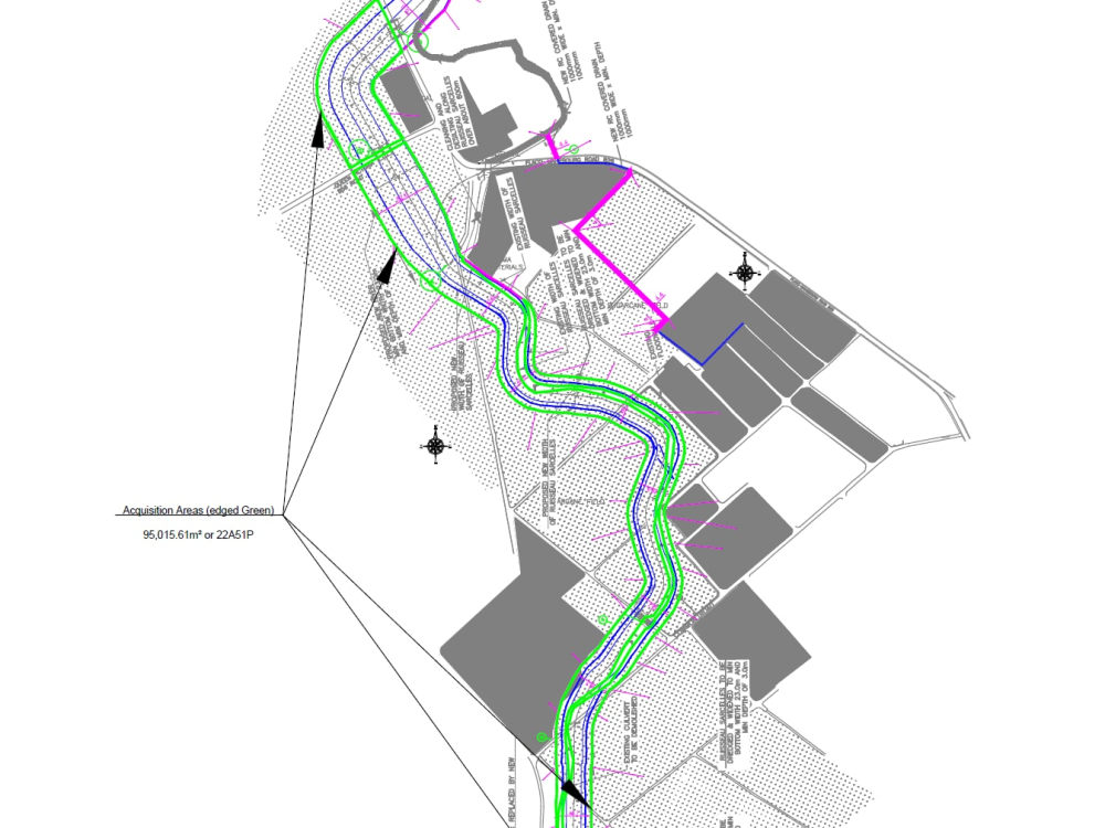
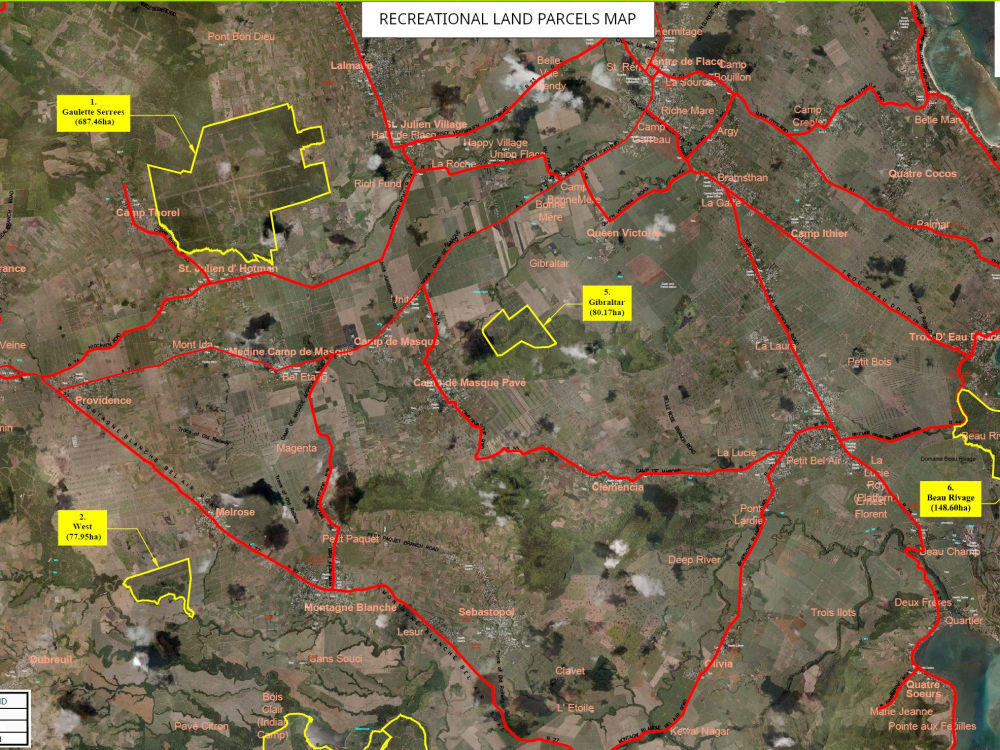
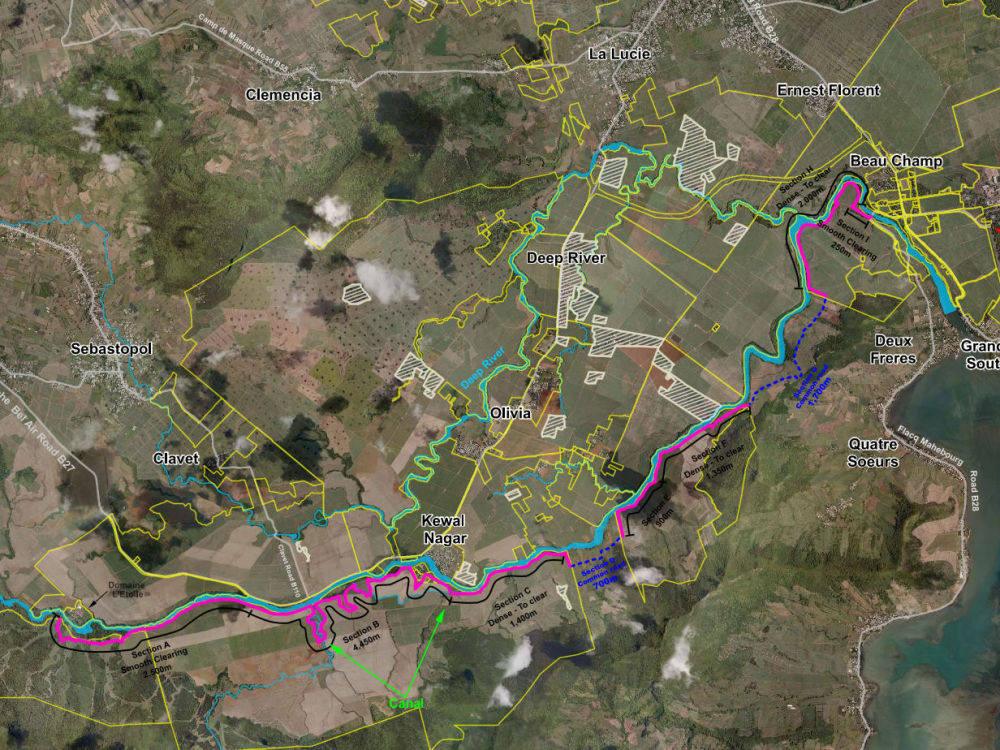
Whether the project involves a Site Analysis & Boundary Map, a Site Constraints Plan, a Proposed Utility Corridor Layout, or detailed Trails, Contours, Topography, and Land Use around a site, I adapt the style to match the intended use - from clean engineering linework to modern, polished layouts suited for planning reports and feasibility studies.
My workflow integrates QGIS, ArcGIS, CAD, and Illustrator, allowing me to pair spatial accuracy with refined design output. Clients can expect structured communication, reliable turnaround, and maps that support confident decision-making while maintaining strong visual hierarchy and clarity.
Data Tool
ArcGISWhat's included
| Service Tiers |
Starter
$50
|
Standard
$80
|
Advanced
$150
|
|---|---|---|---|
| Delivery Time | 5 days | 7 days | 12 days |
Number of Revisions | 2 | 2 | 3 |
Number of Variations | 2 | 2 | 2 |
Data Source Connectivity | |||
Web Embedding | - | - | - |
Interactive/Animated Visuals | - | - | - |
Optional add-ons
You can add these on the next page.
Fast Delivery
+$15 - $45
Additional Revision
+$20
Additional Graph/Chart
(+ 1 Day)
+$20
Additional Variation
(+ 1 Day)
+$20
Site Report
(+ 5 Days)
+$50
GIS & CAD Source Files
(+ 3 Days)
+$30
CAD Conversion Package
(+ 2 Days)
+$30Frequently asked questions
3 reviews
(3)
(0)
(0)
(0)
(0)
This project doesn't have any reviews.
RH
Ray H.
Jan 16, 2026
Land Surveyor Needed
Great job, Chitrasen was very helpful, responsive and resourceful
EM
Emily M.
Apr 15, 2025
Cartographer needed to help clean up a map file in Illustrator
Chitrasen really impressed me with his clear, concise communication and willingness to ask for and take direction!
SW
Steve W.
Apr 9, 2025
San Antonio point of Interest Map
About Chitrasen
Cartography and Mapping | ArcGIS | QGIS | Illustrator | AutoCAD
100%
Job Success
Coromandel, Mauritius - 4:24 am local time
My background includes a BSc in Geosciences (GIS emphasis), a Postgraduate Diploma in GIS, and professional GIS certification from the Geosciences Department at Minnesota State University Moorhead.
My GIS work has also been recognized through a scholarship awarded by the Minnesota GIS/LIS Consortium.
I work across the full geospatial workflow, from raw data processing and georeferencing through spatial analysis, modeling, visualization, map design, and final publication. My approach emphasizes accuracy, methodological transparency, and clean, well-designed outputs suitable for reports, presentations, planning documents, research publications, and digital platforms.
Core Competencies
• GIS mapping and spatial analysis
• Environmental, ecological, hydrological, and agricultural mapping
• DEM/DSM processing, LiDAR, elevation models, and contour generation
• CAD-to-GIS and GIS-to-CAD workflows
• Cartographic design for print and digital use
• Land cover, land use, and time-series analysis
• Flood risk and climate vulnerability mapping
• Satellite, aerial, and drone imagery processing
• OSM-based mapping and geocoding
• Database creation and management (PostGIS/PostgreSQL)
• Report-ready maps, layouts, and technical visualizations
I work primarily in ArcGIS, QGIS, AutoCAD, Adobe Illustrator, Inkscape, and Global Mapper, and can incorporate Python, R, SQL, Javascript and related tools where required.
Technical Experience
Over the past 13 years, I have completed projects involving vegetation and habitat mapping, prairie restoration, agricultural inventories, farmland asset mapping, climate risk assessment, shoreline change analysis, mining impact mapping, watershed and morphometric analysis, urban planning, infrastructure mapping, and population vulnerability studies. I have also worked extensively on land ownership and cadastral datasets, parcel digitization, land dispute mapping, and valuations.
My work includes preparing high-resolution land cover datasets, integrating geodetic control points with satellite imagery, processing LiDAR-derived elevation data, and conducting geostatistical analysis for ecological, agricultural, and development-related studies.
I have developed mobile GIS applications for field teams, delivered Web GIS solutions using Overpass, JavaScript, and Python, and created time-series layers for environmental and agricultural monitoring. Many projects required advanced ArcGIS extensions including Spatial Analyst, 3D Analyst, and Network Analyst.
Publications and Recognitions
My maps and analyses have appeared in official reports by the Minnesota Department of Natural Resources and the LCCMR on prairie and grasslands restoration. I also contributed maps and co-authored a chapter on flood vulnerability and social protection in the book Migration Vulnerability: Access to Social Protection for Select Migrant Categories published by African Sun Media.
Tools and Data Experience
I am comfortable working with raster, vector, LiDAR, DEMs, topographic datasets, GPS data, CAD drawings, geodatabases, Python scripts, SQL queries, large governmental datasets, and custom client data. I handle georeferencing, geocoding, imagery correction, and multi-scale analysis with precision and attention to detail.
How I Work
I am client-focused, organized, and committed to delivering accurate results within agreed timelines. My communication is clear, and I consistently provide progress updates to ensure alignment at all stages. I am flexible with tools and workflows and adapt to the needs of each project. Revisions, corrections, and collaborative refinement are always welcome.
Whether your project requires detailed spatial analysis, custom mapping, technical visualizations, environmental insights, or clean cartographic products, I am committed to providing reliable, high-quality deliverables that meet professional and publication standards.
If you have a specific budget or project scope in mind, my standard rate of $18/hr can be adapted for well-defined or long-term projects to ensure a good fit.
Steps for completing your project
After purchasing the project, send requirements so Chitrasen can start the project.
Delivery time starts when Chitrasen receives requirements from you.
Chitrasen works on your project following the steps below.
Revisions may occur after the delivery date.
Data Preparation
Import site boundary and client-provided datasets into QGIS/ArcGIS. Clean, validate and align all layers to a consistent CRS. Acquire relevant surrounding layers (roads, settlements, contours, land use, utilities, OSM basemaps).
Spatial Analysis
site constraints identification zoning classification 1km–5km buffer analysis trail/road connectivity analysis topographic gradient or contour generation distance to key infrastructure or utilities