You will get Geospatial Machine Learning Mapping Analysis for your needs (scikit-learn)
Project details
A solution for your spatial problem with a map analyzed based on machine learning used Python. I'm certified machine learning analyst with experience doing machine learning more than +5 years. My career journey in Geospatial is amazing from A Speaker, Research Assistant in Reputable University, Practicum Assistant, and Corporate Employment.
submit your data, and i will handle it.
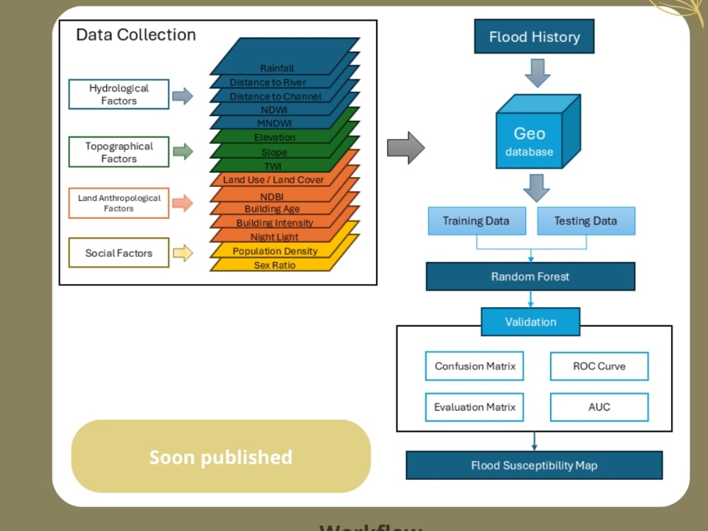
I am familiar with big dataset and handle many remote sensing data, from Sentinel-2 to SAR data, including SRTM, climate, soils, hydrology, land cover, and many more.
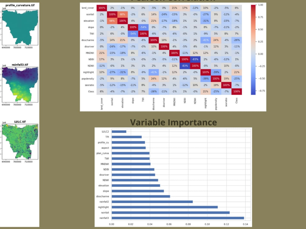
I solved raster, vector data, and extract them with geopandas, rasterio, pyspatialml.
I handle data engineering to create a more suitable data from your big dataset (handling outlier, bias, null, no data, not suitable row , delete or add custom column, add new column). Numpy, pandas, matplotlib.
I visualize them to graph, chart, map, heatmap with Matplotlib and Seaborn
Run machine learning models based from your needs:
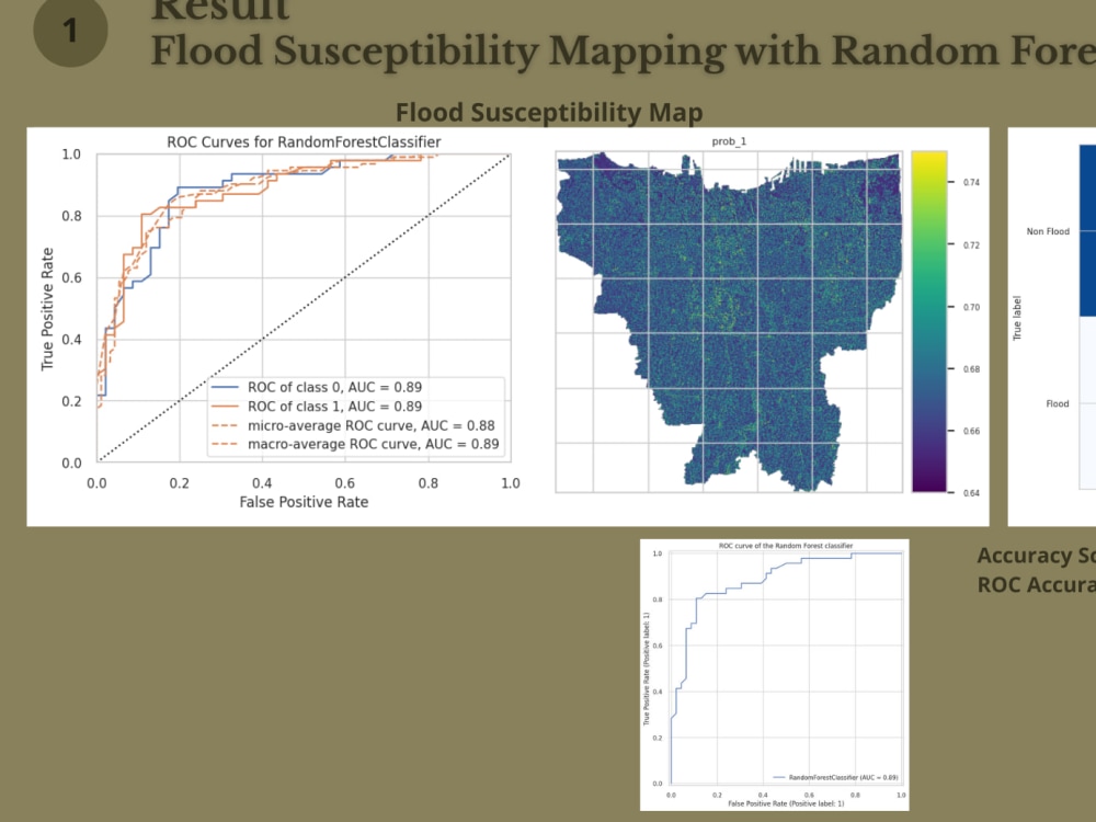
1. Random Forest
2. Logistic Regression
3. Decision Tree
4. Support Vector Machine
5. XGBoost
6. Maximum Entrophy
7. Spectral Linear Unmixing.
All services included source codes.
submit your data, and I will handle it
submit your data, and i will handle it.
I am familiar with big dataset and handle many remote sensing data, from Sentinel-2 to SAR data, including SRTM, climate, soils, hydrology, land cover, and many more.
I solved raster, vector data, and extract them with geopandas, rasterio, pyspatialml.
I handle data engineering to create a more suitable data from your big dataset (handling outlier, bias, null, no data, not suitable row , delete or add custom column, add new column). Numpy, pandas, matplotlib.
I visualize them to graph, chart, map, heatmap with Matplotlib and Seaborn
Run machine learning models based from your needs:
1. Random Forest
2. Logistic Regression
3. Decision Tree
4. Support Vector Machine
5. XGBoost
6. Maximum Entrophy
7. Spectral Linear Unmixing.
All services included source codes.
submit your data, and I will handle it
Machine Learning Tools
ArcGIS, NumPy, pandas, Python, Python Scikit-Learn, scikit-learn, XGBoostWhat's included
| Service Tiers |
Starter
$15
|
Standard
$35
|
Advanced
$40
|
|---|---|---|---|
| Delivery Time | 7 days | 3 days | 1 day |
Number of Revisions | 3 | Unlimited | Unlimited |
Model Validation/Testing | |||
Model Documentation | |||
Data Source Connectivity | - | ||
Source Code |
Optional add-ons
You can add these on the next page.
Additional Revision
+$1
Additional Model Variation
(+ 1 Day)
+$1
Additional Graph/Chart
(+ 1 Day)
+$1
Data Source Connectivity
(+ 1 Day)
+$1About Nur
Geospatial Analysis, GIS, and Remote Sensing
Kediri, Indonesia - 11:39 am local time
Steps for completing your project
After purchasing the project, send requirements so Nur can start the project.
Delivery time starts when Nur receives requirements from you.
Nur works on your project following the steps below.
Revisions may occur after the delivery date.
Client can review and can complain if anything dismissed
Check your goods to secure that It's done for your instructions.