You will get interactive map using mapbox leaflet d3.js geojson openstreetmap svg


Project details
Web mapping is my passion. I have around 10 years of experience in making fully customizable web and GIS maps with Leaflet, Mapbox, OpenLayers, D3.js ArcGIS API for Javascript, Geosrever, ArcGIS server, PostGIS, QGIS, ArcMap as well as Google Earth Engine in remote sensing.
This project includes:
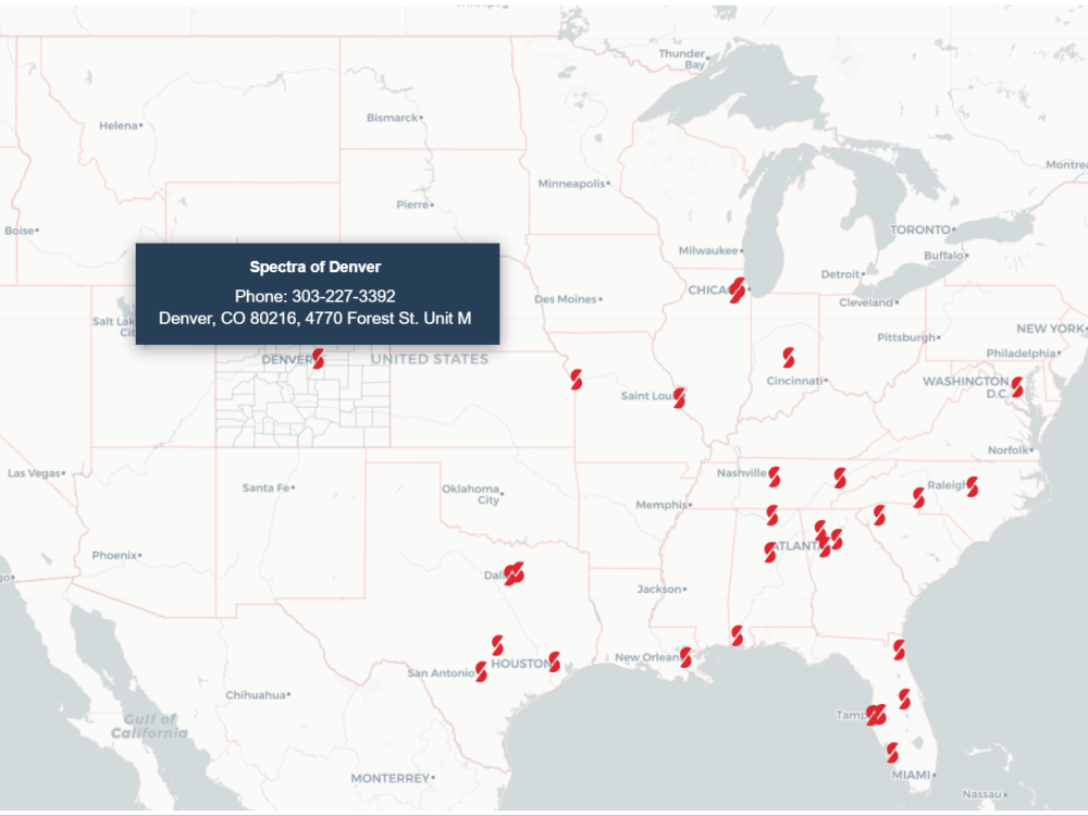
• Interactive map with Leaflet, D3.js, Mapbox, geojson, OpenStreetMap
• Different base map styles
• Address searching (geocoding and reverse geocoding)
• Custom legend, icons, fonts, popups
• Load spatial data from Mapbox Studio, geoserver, wms, wfs, wmts, geojson
• Connection with Google Sheets and csv
• Responsive design
• Layer attributes searching
• Custom filtering
• Embed the map to website
• The area of customization is subject to extra time and budget
This project includes:
• Interactive map with Leaflet, D3.js, Mapbox, geojson, OpenStreetMap
• Different base map styles
• Address searching (geocoding and reverse geocoding)
• Custom legend, icons, fonts, popups
• Load spatial data from Mapbox Studio, geoserver, wms, wfs, wmts, geojson
• Connection with Google Sheets and csv
• Responsive design
• Layer attributes searching
• Custom filtering
• Embed the map to website
• The area of customization is subject to extra time and budget
What's included
| Service Tiers |
Starter
$80
|
Standard
$150
|
Advanced
$200
|
|---|---|---|---|
| Delivery Time | 3 days | 5 days | 7 days |
Number of Revisions | 3 | 4 | 5 |
Number of Graphs/Charts | 1 | 1 | 1 |
Number of Variations | 1 | 1 | 1 |
Data Source Connectivity | - | - | |
Web Embedding | - | - | |
Interactive/Animated Visuals |
About Sakil
GIS MIS Programming Expert - sakilcoder
Petaling Jaya, Malaysia - 5:14 pm local time
- Web Map and Apps on Esri technology (ArcGIS Online, ArcGIS API for JavaScript and Python, ArcGIS Dashboard, Web AppBuilder, Experience Builder, Sruvey123, Field Maps App, ArcGIS Enterprise), Leaflet js, GeoServer, OpenLayers, Geojson, Mapbox
- Web Mapping
- Integrate Basemap like OpenStreetMap, Google Map, Esri Basemap, Carto etc
- Geocoding, Reverse Geocoding
- Spatial Data Analysis
- Remote Sensing Solutions in Google Earth Engine (gee)
- DSS, MIS and ERP Solutions
- API integration
- Website building in Wordpress, WIX
- Web Scrapping
- Enterprise Geodatabase design.
Steps for completing your project
After purchasing the project, send requirements so Sakil can start the project.
Delivery time starts when Sakil receives requirements from you.
Sakil works on your project following the steps below.
Revisions may occur after the delivery date.
Prepare and Analyze Data
1. Collect data from different sources or readily available 2. Prepare data as required to design the map
Design Map
Develop and design an interactive map, add layers, customize popup, add mapping libraries like geocoding, routing, locate etc. Add API from different sources.