You will get cutomized & interactive web maps with Mapbox, Leaflet, google maps api
Top Rated

Project details
This project includes (depending on the service tier):
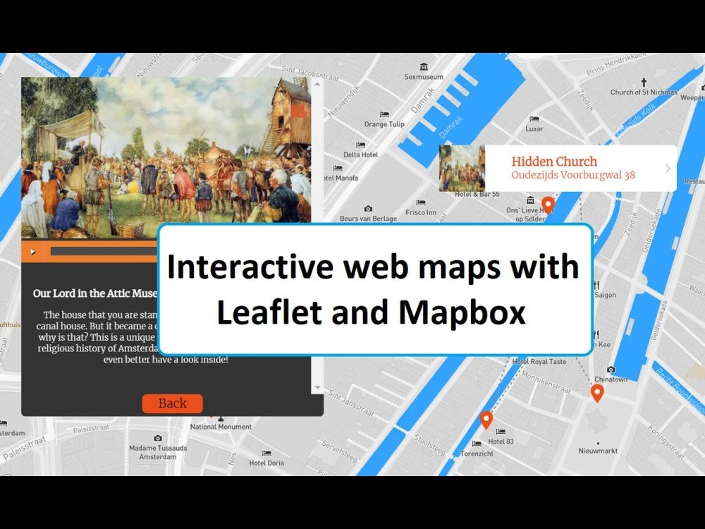
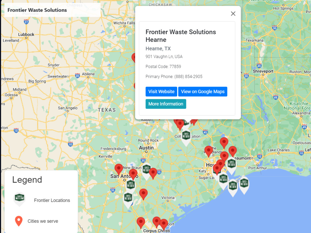
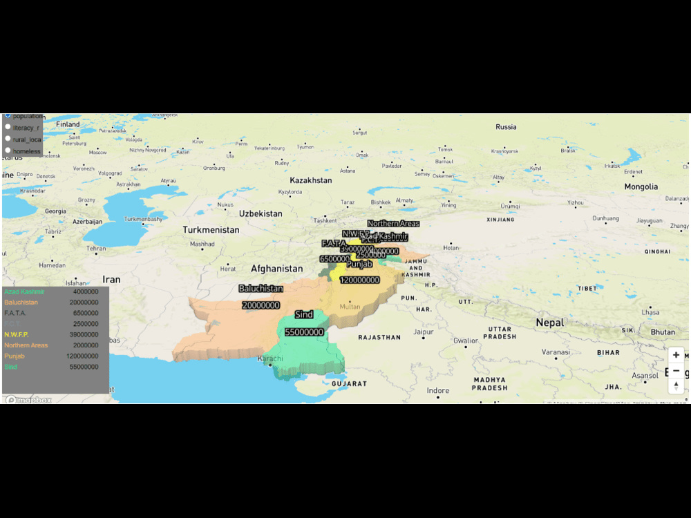
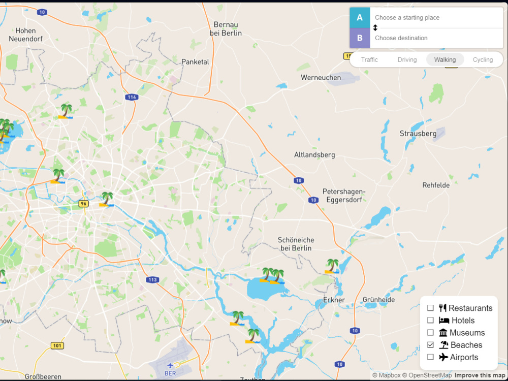
• A beautiful interactive and animated map with Leaflet JS or Mapbox GL JS
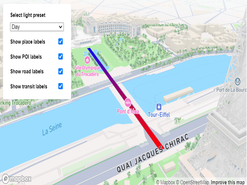
• Different base map styles
• Layers list, which allows the objects view to be toggled
• Custom icons
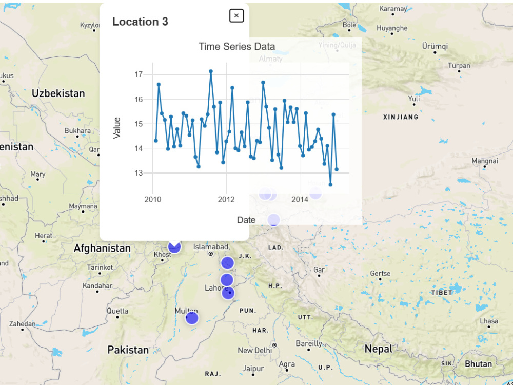
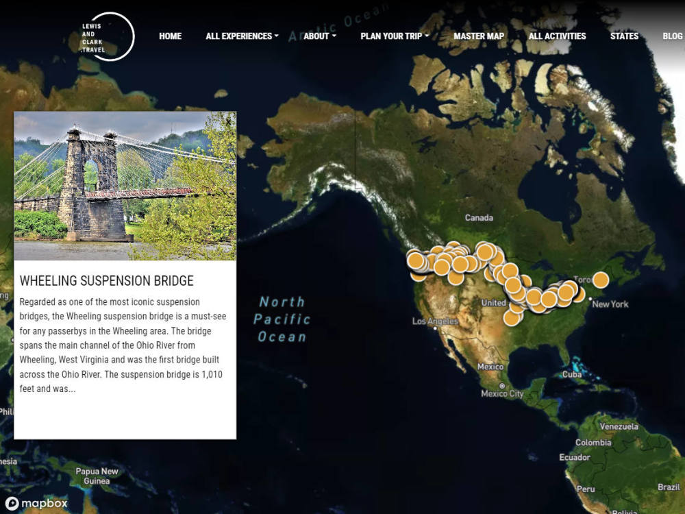
• Custom popups feature to display attributes on click or hover.
• Custom sidebar
• Custom legend
• Custom fonts
• Custom filtering
• Address searching
• Map objects searching
• Displaying all types of objects: points, lines and polygons
• Connection with Google Sheets table, allowing the user to update the map in real time
• Responsive design
• Publish the map to your WordPress/Squarespace/Weebly/Wix/Webflow website
• Extra fast delivery
Please, I would ask you to discuss your requrements before making the order.
• A beautiful interactive and animated map with Leaflet JS or Mapbox GL JS
• Different base map styles
• Layers list, which allows the objects view to be toggled
• Custom icons
• Custom popups feature to display attributes on click or hover.
• Custom sidebar
• Custom legend
• Custom fonts
• Custom filtering
• Address searching
• Map objects searching
• Displaying all types of objects: points, lines and polygons
• Connection with Google Sheets table, allowing the user to update the map in real time
• Responsive design
• Publish the map to your WordPress/Squarespace/Weebly/Wix/Webflow website
• Extra fast delivery
Please, I would ask you to discuss your requrements before making the order.
Programming Languages
HTML & CSS, JavaScript, TypeScriptCoding Expertise
Cross Browser & Device Compatibility, W3C Markup Validation Service, DesignWhat's included
| Service Tiers |
Starter
$50
|
Standard
$100
|
Advanced
$250
|
|---|---|---|---|
| Delivery Time | 1 day | 3 days | 7 days |
Number of Revisions | Unlimited | Unlimited | Unlimited |
Number of Pages | 2 | 3 | 5 |
Design Customization | |||
Content Upload | - | - | |
Responsive Design | - | ||
Source Code |
Optional add-ons
You can add these on the next page.
Fast Delivery
+$10 - $100
Additional Page
(+ 1 Day)
+$20
Content Upload
(+ 1 Day)
+$20
Responsive Design
(+ 1 Day)
+$10Frequently asked questions
22 reviews
(21)
(1)
(0)
(0)
(0)
This project doesn't have any reviews.
CM
Caleb M.
Jun 3, 2026
Web Developer Needed for Map-Based Data Visualization Dashboard (MVP)
Kashif was excellent to work with. He helped build the foundation for my map-based CSV visualization dashboard and delivered exactly what I needed to get the project moving. He was responsive, easy to communicate with, and handled changes and feedback throughout the process. The final product gave me a strong starting point that I was able to continue improving and expanding. I would definitely recommend him for web app and dashboard development projects.
GV
Ginny V.
May 19, 2026
Graphic Designer Needed to Create 3D Festival Map (ICOgram Preferred)
MF
Mark F.
Apr 22, 2026
GLP WordPress - Mapbox integration (phase 1)
A really good experience working with Kashif on our Mapbox projects. We delivered a solution that the client was delighted with. Kashif was super helpful throughout the project, giving advice that demonstrated his knowledge of the software. We will definitely use him again once our project goes into its next phase.
BT
Ben T.
Mar 14, 2026
GIS data scrub
Highly recommend!
DC
Dimitri C.
Nov 21, 2025
Map App
Hire him, He has a smooth process.
About Kashif
GIS Developer|Web Gis Specialist|GoogleMaps api |Mapbox expert
100%
Job Success
Islamabad, Pakistan - 1:01 am local time
✅ 6+ years of experience
✅ 50+ projects delivered with 5 star rating
✅ Available to collaborate seamlessly in US time zones
Hi, I'm a seasoned GIS specialist and full-stack developer, on a mission to deliver excellence in interactive web mapping. Leveraging industry-leading technologies such as Mapbox, Leaflet, and OpenLayers, I create high-quality, tailored solutions that meet your project’s unique needs. With a robust foundation in HTML, CSS, JavaScript, Python, ReactJS, and React Native, along with expertise in geospatial analysis, data management, and web mapping technologies like PowerBI and ArcGIS, I'm committed to driving impactful solutions
My ability to effectively communicate and collaborate with cross-functional teams, along with my strong problem-solving and analytical skills, ensures that your interactive web maps are not only functional but also visually compelling. My passion for Mapbox and Leaflet allows me to push the boundaries of what’s possible in web mapping, making me a valuable asset to your team.
⭐ My strengths and skills:
✅ Full-Stack Development: Proficient in both front-end and back-end development, including HTML, CSS, JavaScript, and frameworks like ReactJS, React Native, and Angular for building user interfaces. I also have experience with server-side technologies like Node.js, Laravel, or Django for building robust APIs and handling data processing that power interactive web maps.
✅ Geospatial Expertise: In-depth knowledge of GIS principles, spatial databases (e.g., PostGIS), and geospatial data formats (e.g., GeoJSON, Shapefile), with a solid understanding of coordinate systems, map projections, and spatial analysis techniques that are crucial for creating accurate interactive web maps using Mapbox, Leaflet, and OpenLayers.
✅ Web Mapping Technologies: Extensive experience with Mapbox, Leaflet, and OpenLayers to create interactive web maps that are both visually appealing and highly functional. I can customize these web maps to meet your unique requirements, ensuring seamless integration with your existing systems and optimal performance.
✅ Database Management: Proficient in working with relational databases (e.g., PostgreSQL, MySQL) and spatial databases (e.g., PostGIS) for efficient storage and retrieval of geospatial data. My experience in database management ensures that your Mapbox and Leaflet interactive web maps have fast and reliable data access.
✅ Data Visualization: Skilled in visualizing geospatial data using charting libraries like D3.js or Plotly. I create intuitive and informative data visualizations that enhance your interactive web maps developed with Mapbox, Leaflet, and OpenLayers.
✅ Spatial Analysis and Modeling: Capable of performing advanced spatial analysis tasks such as buffering, overlaying, network analysis, and geoprocessing. My expertise in tools like ArcGIS, QGIS, and ArcGIS Pro complements my work in developing interactive web maps with Mapbox and Leaflet.
✅ Version Control and Collaboration: Proficient in using version control systems like Git for code management and collaboration within development teams. My approach ensures that your interactive web maps built with Mapbox and Leaflet are maintained with the highest standards.
✅ Problem-Solving and Analytical Skills: Strong analytical thinking and problem-solving abilities enable me to address complex spatial challenges and develop innovative solutions using Mapbox, Leaflet, OpenLayers, and other geospatial technologies. Whether you need to optimize map performance or customize map styles, I have the expertise to deliver results.
✅ Communication and Collaboration: Excellent communication skills allow me to effectively collaborate with cross-functional teams & clients. I translate technical concepts into understandable terms and work in agile development environments, ensuring your interactive web maps meet all project requirements.
⭐ Technologies:
Geographic Information Systems (GIS) Software: ArcGIS, QGIS.
Spatial Databases: PostgreSQL with PostGIS, Microsoft SQL Server.
Programming Languages: Python, JavaScript, SQL.
Web Mapping Libraries: Leaflet, OpenLayers, Mapbox GL JS, CesiumJS, Potree.
GIS APIs: Google Maps API, ArcGIS API for JavaScript, Mapbox API, MapTiler API.
Front-end Frameworks: React, Angular, Wordpress
Back-end Frameworks: Node.js, Django, GeoServer.
Data Visualization: D3.js, Plotly.
Geospatial Analysis: GDAL, P, rasterio, TurfJS, GeoPandas.
Spatial ETL (Extract, Transform, Load): FME.
Version Control: Git, GitHub, Bitbucket.
Cloud Computing: Amazon Web Services (AWS)
Mobile Development: React Native.
Containerization: Docker.
Data Formats: GeoJSON, Shapefile, KML, GeoTIFF, vector tiles.
Let’s connect to discuss how my expertise in Mapbox help your business
Steps for completing your project
After purchasing the project, send requirements so Kashif can start the project.
Delivery time starts when Kashif receives requirements from you.
Kashif works on your project following the steps below.
Revisions may occur after the delivery date.
Step1: Data collection
Here i will collect data myself or get it from client
Step2: map creation
Here i will start working on the data provided by the client and make the map