You will get object Detection from Satellite Imagery with AI – 24hr Delivery
Project details
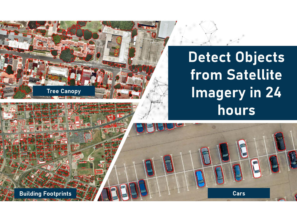
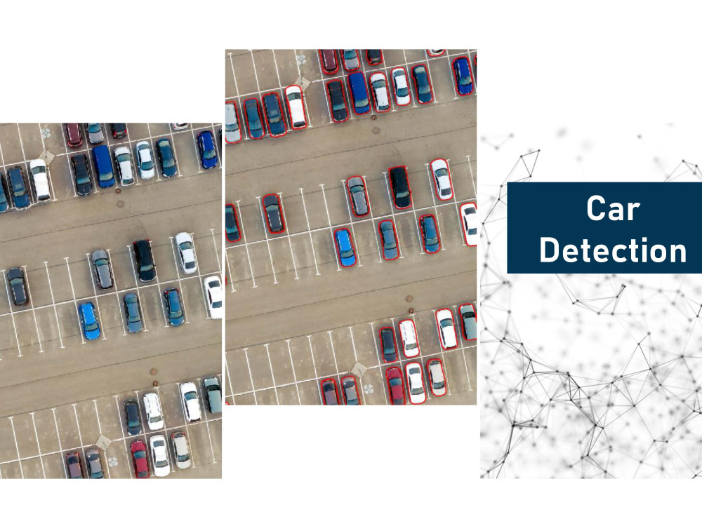
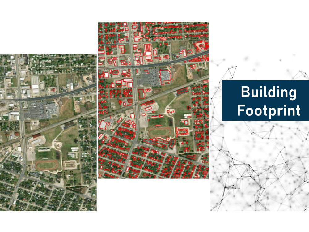
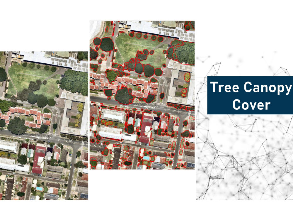
🚀 Need accurate object detection from satellite or aerial imagery in 24 hours? I specialize in fast, high-quality detection for diverse applications—urban planning, agriculture, energy, and more.
🔍 Objects I can detect:
🏠 Buildings | 🌳 Trees | 🏊 Pools | ⚫ Oil Pads | ☀️ Solar Panels | 🛣️ Roads | 🌊 Rivers/Canals | 🌾 Paddy Fields | 🪨 Open Land | 🚧 Construction Sites | 🏞️ Terrain | 🔋 Wind Turbines | 🏖️ Beaches | 🛤️ Railways | 🏕️ Campsites — and more!
📦 What You’ll Get:
1.Geo-referenced vector files (GeoJSON, Shapefiles, KML)
2.Visual overlay maps (with masks or bounding boxes)
Optional: Object counts, area summaries, heatmaps
💬 No imagery? No problem! I can assist in sourcing free or commercial satellite data for your area of interest.
Just send your area of interest and object list—I’ll take care of the rest. Let’s turn satellite data into real-world insights 🌍
AI Development Type
Deep LearningAI Development Language
PythonWhat's included
| Service Tiers |
Starter
$100
|
Standard
$800
|
Advanced
$1,500
|
|---|---|---|---|
| Delivery Time | 1 day | 2 days | 3 days |
Number of Revisions | 3 | 3 | 3 |
AI Model Integration | |||
Detailed Code Comments | - | - | - |
Knowledge Graph | - | - | - |
Model Documentation | - | - | - |
Ontology | - | - | - |
Source Code | - | - | - |
Taxonomy | - | - | - |
Optional add-ons
You can add these on the next page.
Statistical Report
+$150
High-Quality Map Exports
+$75
New Object Type (Custom Model Training)
+$250Frequently asked questions
37 reviews
(31)
(3)
(2)
(1)
(0)
This project doesn't have any reviews.
LD
Luke D.
Mar 1, 2026
Building Conservation Specialist Needed for Planning Permission Assistance
LL
Lauren L.
Nov 21, 2025
GIS Feature Identification
Working with Mahid has been an exceptional experience. He is highly responsive, technically skilled, and consistently delivers high-quality work. His ability to translate our complex modeling needs into usable outputs has made a significant impact on our project.
OS
Omri S.
Oct 31, 2025
Developer to Build Roof Estimator API
Unfortunately, this experience was disappointing. The freelancer consistently over-promised and under-delivered. The project took far longer than expected and required numerous revisions, yet the final result was still not usable. Despite my concerns, I released the milestones payments based on assurances that the finished product would improve — but we never reached a satisfactory completion.
I requested a refund due to the lack of a usable outcome, but it was declined. I ultimately lost both time and money without receiving the product I paid for.
If you choose to work with this freelancer, I strongly recommend paying only upon delivery of a completed and satisfactory final product. This was a hard lesson learned for me — proceed with caution.
KM
Kyle M.
Oct 22, 2025
30 minute consultation
Talking to Mahid is like when one of your extremely smart and talented pals you’ve known for 30 years shows up on your driveway and has something really cool to show you that will help your business tremendously.
LC
Louise C.
Oct 1, 2025
Town planner help
Absolute pleasure to work with. Communication throughout was amazing. Would highly recommend
About Mahid
GIS | Remote Sensing | GeoAI & Object Detection Specialist
78%
Job Success
Southend-on-Sea, United Kingdom - 8:53 am local time
Struggling to extract actionable insights from geospatial data? I combine GIS, remote sensing, and AI to deliver precise object detection and spatial analysis — from buildings 🏢 and roads 🛣️ to crops 🌾 and environmental changes 🌿.
🔧 Services I Provide
• 🤖 Custom AI Object Detection: Buildings, roads, water bodies, crops, forests, disaster zones
• 🗺️ Advanced GIS & Remote Sensing: Spatial modeling, mapping, visualization
• 📊 GeoAI & Machine Learning: Land use classification, predictive modeling
• ☁️ Spatial Databases & Cloud GIS: AWS, GCP integration
• 📈 Interactive Dashboards & Reports: Easy-to-understand spatial insights
🔍 What kinds of objects can I detect for you? Here’s a taste:
🏙️ Buildings, roads, bridges, parking lots, solar panels
🌾 Crop fields, irrigation canals, greenhouses, deforestation zones
🌊 Rivers, lakes, wetlands, flood extents, coastal changes
🌲 Forest canopy, logging sites, fire scars, reforestation areas
⚠️ Post-disaster damage, landslides, erosion, wildfire impact
🚧 Highways, railways, airports, ports, toll booths
🛢️ Oil tanks, mining sites, and more (custom requests welcome!)
⭐ Why Choose Me?
• 🎯 Tailored solutions for your unique needs
• 💬 Clear communication & on-time delivery
• 🔍 Proven expertise transforming imagery into insight
📩 Ready to turn your geospatial data into real impact? Let’s connect!
Steps for completing your project
After purchasing the project, send requirements so Mahid can start the project.
Delivery time starts when Mahid receives requirements from you.
Mahid works on your project following the steps below.
Revisions may occur after the delivery date.
1. Requirement Submission
Client provides area of interest (coordinates, map, or shapefile), list of objects to detect, and imagery (if available). I can help source imagery if needed.
2. Image Preparation
I verify or acquire the satellite imagery, preprocess it (crop, align, enhance), and prepare it for analysis.