You will get GIS Analyst | Raster, Vector & Map Design using QGIS and ArcGIS
Project details
Looking for a professional GIS Analyst to turn your spatial data into clear, accurate maps?
I specialize in raster and vector data processing, spatial analysis, and map design using QGIS and ArcGIS.
With over 4 years of experience in GIS and Remote Sensing, I’ve worked with UNESCO, government departments, and research institutions to produce precise, meaningful, and visually appealing maps.
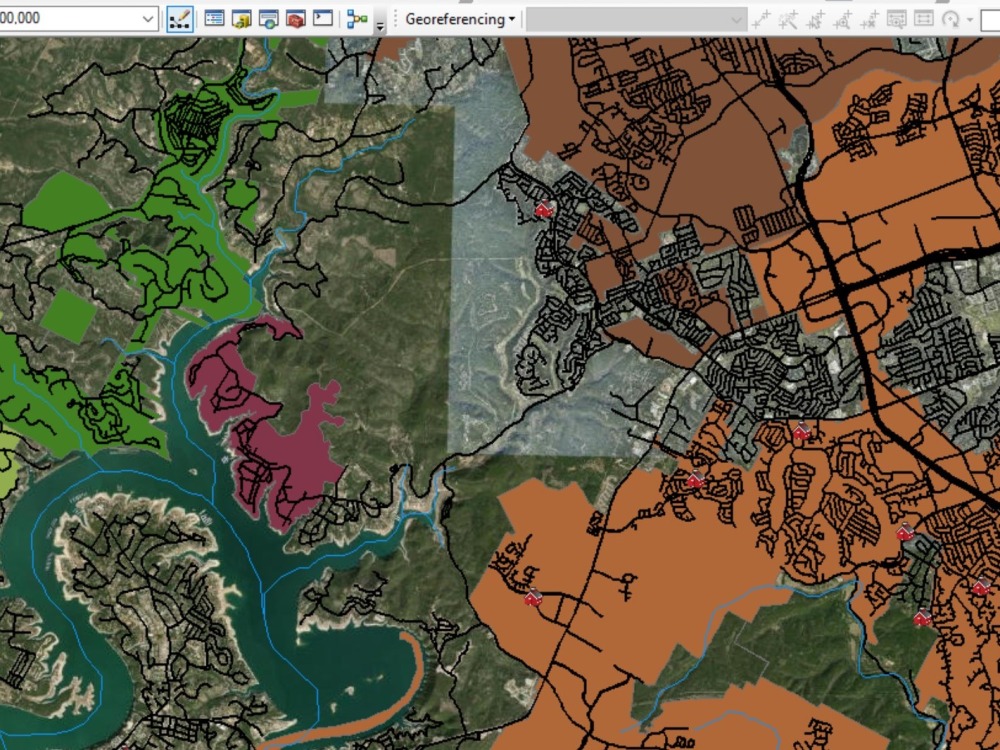
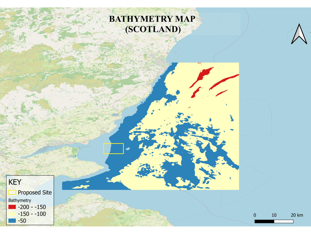
Whether you need land use/land cover mapping, field boundary labeling, change detection, or custom map layouts, I deliver high-quality results that help you make informed, data-driven decisions.
Each project is handled with attention to detail, spatial accuracy, and professional cartographic design.
Let’s collaborate to transform your geospatial data into beautiful, informative maps. 🌍
#GISAnalyst #QGIS #ArcGIS #GISMapping #RasterData #VectorData
#SpatialAnalysis #Cartography #MapDesign #RemoteSensing #LULCMapping
#EnvironmentalGIS #GeospatialAnalysis
I specialize in raster and vector data processing, spatial analysis, and map design using QGIS and ArcGIS.
With over 4 years of experience in GIS and Remote Sensing, I’ve worked with UNESCO, government departments, and research institutions to produce precise, meaningful, and visually appealing maps.
Whether you need land use/land cover mapping, field boundary labeling, change detection, or custom map layouts, I deliver high-quality results that help you make informed, data-driven decisions.
Each project is handled with attention to detail, spatial accuracy, and professional cartographic design.
Let’s collaborate to transform your geospatial data into beautiful, informative maps. 🌍
#GISAnalyst #QGIS #ArcGIS #GISMapping #RasterData #VectorData
#SpatialAnalysis #Cartography #MapDesign #RemoteSensing #LULCMapping
#EnvironmentalGIS #GeospatialAnalysis
Data Tool
ArcGISWhat's included
| Service Tiers |
Starter
$25
|
Standard
$40
|
Advanced
$80
|
|---|---|---|---|
| Delivery Time | 2 days | 3 days | 4 days |
Number of Revisions | 2 | 3 | 5 |
Number of Graphs/Charts | 0 | 0 | 0 |
Data Source Connectivity | - | - | - |
Web Embedding | - | - | - |
Interactive/Animated Visuals | - | - | - |
Frequently asked questions
3 reviews
(3)
(0)
(0)
(0)
(0)
This project doesn't have any reviews.
PY
Pragati Y.
May 4, 2026
Land use land cover classification
AE
Amran E.
Mar 28, 2026
Remote Sensing & GIS Expert Needed for Comparative Agro-Environmental Analysis
Wasila delivered high-quality work with professionalism and consistency. Communication was smooth, deadlines were respected, and she handled feedback with great attention to detail. I appreciate her commitment and the effort she puts into every task. I highly recommend working with her.
MF
Michael F.
Aug 10, 2025
QGIS - (World Mercador) export as TIFF/GEOTIFF in a specific crs like 31468
Wasila was a top choice. She explained everything step for step and creates me an introduction with screenshots and everything I want/need. I can higly recommend her :)
About Wasila
GIS Analyst | QGIS & ArcGIS Expert | Remote Sensing | Map Design
75%
Job Success
Hunza, Pakistan - 1:59 am local time
I have successfully completed projects for UNESCO, universities, and government departments, delivering precise and visually compelling GIS maps and spatial reports. My expertise ensures data accuracy, clear map layouts, and valuable geospatial insights.
🌍 Core Expertise
GIS Analysis: Spatial data extraction, transformation, and analysis using QGIS and ArcGIS.
Remote Sensing: Land Use/Land Cover (LULC) mapping, change detection, and environmental monitoring.
Cartography & Map Design: Aesthetic and data-driven maps with attention to clarity and detail.
Data Visualization: Turning geospatial data into clear visual stories with R, Excel, and GIS tools.
Geospatial Data Management: Handling shapefiles, raster datasets, and coordinate systems efficiently.
💡 Why Work With Me
4+ years of professional GIS and Remote Sensing experience.
Trusted by organizations like UNESCO and government agencies.
Strong focus on accuracy, detail, and client satisfaction.
Fast, reliable communication and delivery.
🚀 Let’s Work Together
If you need a QGIS or ArcGIS specialist to turn raw geospatial data into accurate maps and actionable insights, I’m ready to bring your project to life.
Let’s connect and discuss how I can support your goals.
#GISAnalyst #QGIS #ArcGIS #RemoteSensing #Cartography #MapDesign #SpatialAnalysis #GISMapping #DataVisualization #GeospatialData #LULC #ChangeDetection #ThematicMapping #GeospatialAnalysis #GISProfessionalv
Steps for completing your project
After purchasing the project, send requirements so Wasila can start the project.
Delivery time starts when Wasila receives requirements from you.
Wasila works on your project following the steps below.
Revisions may occur after the delivery date.
Initial Consultation:
Contact us to discuss your project needs.
Approval & Agreement:
Once you approve the proposal, we’ll finalize the agreement and begin work.