You will get Road Geometry, Building Footprint, POI Geometry

Project details
Introducing Automation Exception Your partner for cutting-edge spatial data production. Our cutting-edge software and resources will help you to get along with your data production activities.
We source our data from publically available maps and Imagery.
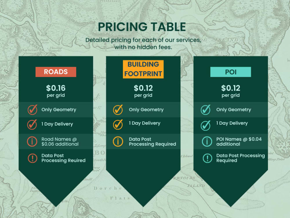
Our pricing model depends on the number of grids that fall within the provided AOI. You can calculate the project price by Gridding your Data as follows:
POI = 250mx250m Grids
ROADS = 500mx500m Grids
BUILDING = 250mx250m Grids
Please note the Data has to be QC'd and processed before passing into delivery.
We source our data from publically available maps and Imagery.
Our pricing model depends on the number of grids that fall within the provided AOI. You can calculate the project price by Gridding your Data as follows:
POI = 250mx250m Grids
ROADS = 500mx500m Grids
BUILDING = 250mx250m Grids
Please note the Data has to be QC'd and processed before passing into delivery.
Data Tool
ArcGISWhat's included $10
These options are included with the project scope.
$10
- Delivery Time 3 days
- Number of Revisions 0
Optional add-ons
You can add these on the next page.
Scrapped Attributes
(+ 2 Days)
+$1Frequently asked questions
About Pradipta
GIS Developer | Python | Geospatial Deep Learning |
Bhilai, India - 8:43 pm local time
I am a seasoned GIS developer with Experience in Developing and delivering solutions using ESRI and other Opensource Tools/API. I have been working in this Domain for ten years now.
What I can do for you
✔️ Create Automation Scripts in ArcGIS/Opensource GIS
✔️ Setup complete Data Automation using open-source Tech Stack.
✔️ Raster Processing, Raster Analysis, and Raster Computation
✔️ DEM processing, Biomass Estimation, NDVI
✔️ Architect/Develop and deploy a Geospatial Application from End to End.
✔️ Provide you with insights into your current Geospatial Data, helping you to Automate your tasks
✔️ Developing Enterprise level application in GIS using ESRI and OpenSource Solution
✔️ Managing Spatial Databases
✔️ Developing Applications using NoSQL Databases (Elastic Search, MongoDB)
✔️ Expertise in ESRI and Open-Source GIS
✔️ Building and Deploying Deep Learning Models for Feature Extraction.
Benefits for hiring me
👉🏻 Bringing Experience from multiple organizations/domains on the table.
👉🏻 Flexible to work as per your requirement and schedule
👉🏻Pay only when you are satisfied
👉🏻 Agility to interview/ sample task for a long-term contract
👉🏻 Willing to work on the experimental technology stack
Steps for completing your project
After purchasing the project, send requirements so Pradipta can start the project.
Delivery time starts when Pradipta receives requirements from you.
Pradipta works on your project following the steps below.
Revisions may occur after the delivery date.
Client Send us an AOI and Features to be extracted for the Demo Data.
To start with you will send us an AOI to receive a Demo Data. Please make sure that the AOI is in EPSG:4326. please send us AOI with not more than 1 sq. km.
The client inspects the Demo Data
As we send you a demo data you inspect the demo data and decide a go no go with the project.