You will get USA County Parcel & Assessor Data Collection and PostGIS Pipeline
Project details
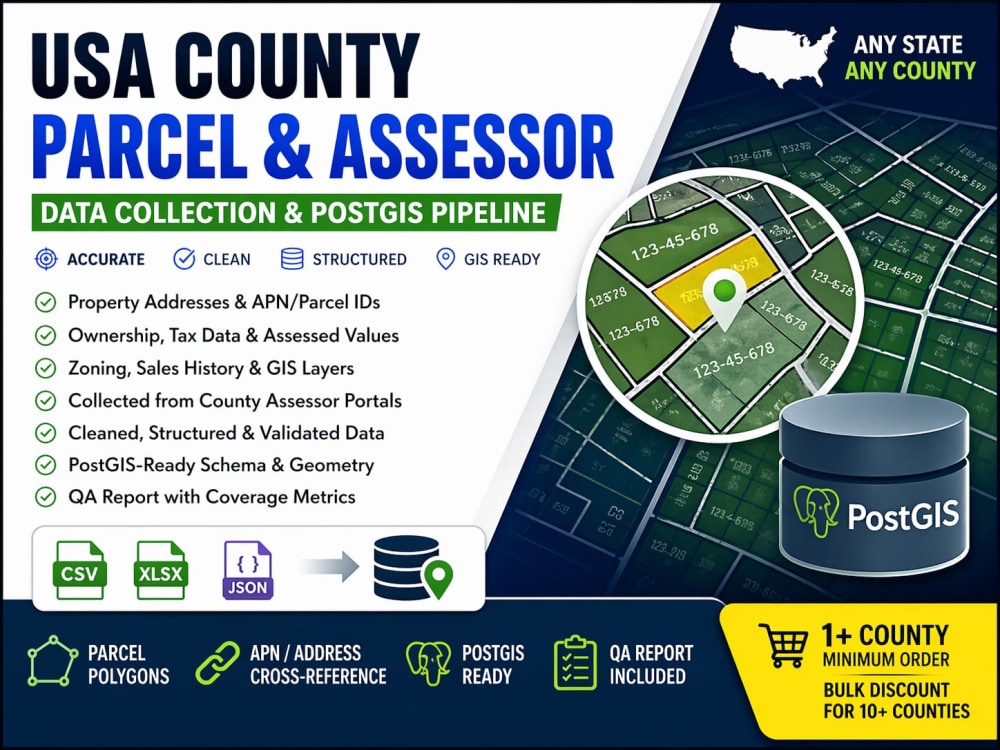
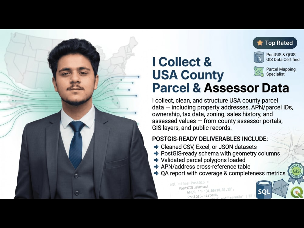
I collect, clean, and structure USA county parcel data — including property addresses, APN/parcel IDs, ownership, tax data, zoning, sales history, and assessed values — from county assessor portals, GIS layers, and public records.
Delivery includes:
• Cleaned CSV, Excel, or JSON dataset
• PostGIS-ready schema with geometry columns
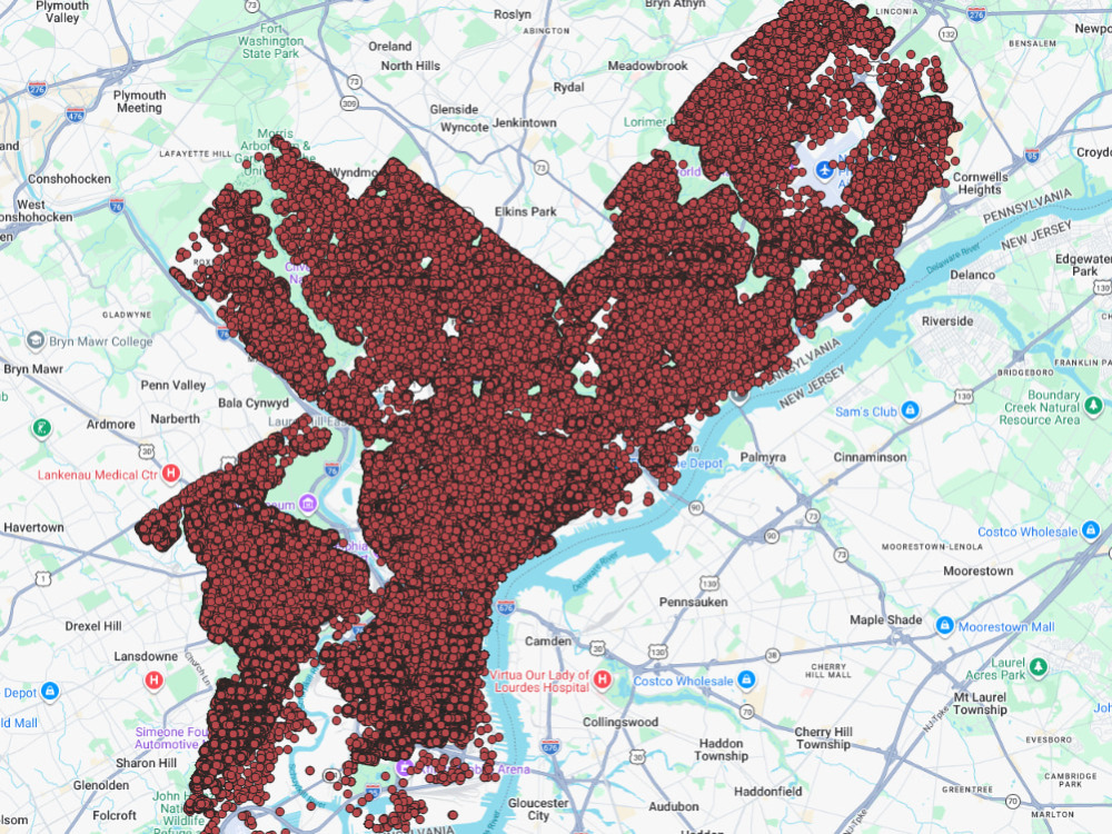
• Parcel polygons loaded and validated (if GIS data available)
• APN/address cross-reference table
• QA report with coverage and completeness metrics
This service covers any US state or county. Minimum order: 1 county. Bulk pricing available for 10+ counties.
Delivery includes:
• Cleaned CSV, Excel, or JSON dataset
• PostGIS-ready schema with geometry columns
• Parcel polygons loaded and validated (if GIS data available)
• APN/address cross-reference table
• QA report with coverage and completeness metrics
This service covers any US state or county. Minimum order: 1 county. Bulk pricing available for 10+ counties.
Data Tool
PythonWhat's included
| Service Tiers |
Starter
$100
|
Standard
$250
|
Advanced
$500
|
|---|---|---|---|
| Delivery Time | 2 days | 4 days | 6 days |
Number of Pages Mined/Scraped | 1 | 5 | 20 |
Number of Sources Mined/Scraped | 1 | 5 | 20 |
Number of Revisions | 1 | 5 | Unlimited |
Optional add-ons
You can add these on the next page.
Fast Delivery
+$25 - $150Frequently asked questions
About Waqas
Data Engineer | Python | PostgreSQL | AWS | ETL | Scraping | USA DATA
Islamabad, Pakistan - 10:24 pm local time
I help companies collect, clean, structure, and scale data using Python, PostgreSQL/PostGIS, AWS, ETL pipelines, and advanced web scraping automation. My goal is always automation, consistency, and clean, production-ready solutions that your team can actually use.
What I Can Do for You
✅ Design and build end-to-end automated ETL data pipelines
✅ Integrate disparate data sources — APIs, websites, files, databases
✅ Set up and maintain SQL databases (PostgreSQL, PostGIS)
✅ Deploy services and APIs in the cloud (AWS, Docker)
✅ Develop RESTful APIs for data delivery
✅ Data Mining and Web Scraping (Python, BeautifulSoup, Scrapy, Selenium, Playwright)
✅ Set up CI/CD pipelines (GitHub Actions, Jenkins) for reliable releases
✅ Containerize applications for smooth, portable deployment
✅ Process and engineer complex GIS and geospatial datasets
✅ Build USA property, parcel, permit, zoning, and real estate data systems
Data Engineering
End-to-end ETL pipeline development
Data ingestion from APIs, websites, files, and databases
Data cleaning, normalization, transformation, and validation
Automated data pipelines in Python
Batch and scheduled processing
AWS-based data workflows (S3, EC2, Lambda)
Data warehouse-ready outputs
Data QA and monitoring
Large-scale structured dataset generation
Web Scraping & Extraction
Custom Python scrapers
Dynamic and JavaScript-rendered page extraction
Pagination and workflow automation
Table, listing, directory, and portal extraction
PDF, file, and document download automation
Public records scraping
Structured output delivery (CSV, Excel, JSON, Google Sheets, PostgreSQL)
Scheduled recurring scraping jobs
PostgreSQL / PostGIS
Database design and optimization
PostGIS spatial queries
Geometry cleaning and validation
CRS/SRID transformations
Spatial joins and indexing
Geospatial ETL pipelines
Large spatial data imports and updates
USA Property / Real Estate / GIS Data (Deep Specialty)
Parcel, zoning, and land use data pipelines
Ownership, assessor, permit, deed, mortgage, tax, and foreclosure data
GIS boundary maps and geospatial layer processing
Parcel number and APN matching
Address standardization and geocoding support
County, city, and state-level public records integration
Real estate intelligence datasets for analysis or product use
APIs & Cloud Automation
REST API integrations and custom API-based data delivery
Cloud deployment workflows on AWS
Dockerized automation systems
CI/CD pipelines with GitHub Actions and Jenkins
Monitoring and refreshing pipelines
Tools & Technologies
Languages: Python, SQL
Databases: PostgreSQL, PostGIS
Cloud: AWS (S3, EC2, Lambda, Elastic Beanstalk)
Containerization: Docker
CI/CD: GitHub Actions, Jenkins
Python Libraries: pandas, GeoPandas, NumPy, Shapely, requests, BeautifulSoup, Scrapy, Selenium, Playwright, httpx
GIS / Spatial: PostGIS, QGIS, ArcGIS, GeoJSON, Shapefile, WKT/WKB
Output: CSV, Excel, JSON, Google Sheets, PostgreSQL/PostGIS, API-ready datasets
Why Clients Hire Me
I don't just write scripts — I build usable data systems.
That means I help clients collect the right data, clean and structure it properly, store it in the right schema, validate quality, automate refreshes, and deliver it in a format their team can actually use.
Whether your project involves business data pipelines, web scraping at scale, cloud automation, or large-scale USA real estate and GIS datasets, I build reliable, maintainable solutions from day one.
Send me a message with your data source, target output, and business goal, and I'll help you map out the right workflow.
Steps for completing your project
After purchasing the project, send requirements so Waqas can start the project.
Delivery time starts when Waqas receives requirements from you.
Waqas works on your project following the steps below.
Revisions may occur after the delivery date.
Review scope and source data
I review the target counties, required attributes, source material, output format, and database requirements to define the collection and loading workflow.
Collect and structure data
I gather the parcel and assessor data, standardize fields, clean inconsistencies, and prepare it for reliable spatial and tabular loading.